Winter Weather Advisory
Bitter Cold Early Next Week
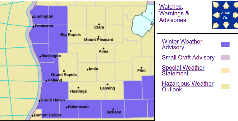
The Winter Weather Advisory has been canceled for Kent, Ionia, Barry, Montcalm, Mecosta, Osceola, Eaton, Ingham and Clinton Counties.
The Winter Weather Advisory remains continues for the counties in purple on the map. This is for anywhere from 1-6” of new snow, along with slippery road conditions and a chance of a little drifting snow. There was one report of 8” of new snow near Wayland. Other snow depths: 10” Gobles, 8: near Lansing, Holland and Traverse City. There was one report west of downtown Holland of 12” of snow on the ground.
Other snow depth reports: 7” Grandville, Plainwell, Hastings, White Cloud and Scottville, 6” at Grand Rapids, Muskegon, Fremont, Big Rapids, East Gr. Rapids, Grand Ledge, Caledonia and Grand Ledge, 5” at Kalamazoo, Hart, Houghton Lake, Lake City and 4” at Alpena.
S. Ste. Marie is now over 100” of snow for the winter.
The areas northeast of Kent County will likely see 1-3” of new snow with areas from Grand Rapids to Kalamazoo are more likely to see 3-6” of new snow. Temperatures will be chilly - only around 18°-20° this aftenoon, so the snow will be light and powdery and more apt to blow around in th 10-15 mph west (to northwest) wind.
Here’s radar, current Michigan weather observations, a Michigan weather map and the latest Grand Rapids National Weather Service Forecast Discussion.
The other big story is the Arctic Express/Polar Vortex that’s bringing bitter cold temperatures to much of the eastern U.S. early next week. The GFS model for next Tuesday morning shows a gigantic 1050 mb high pressure center over eastern South Dakota. The thickness (dotted blue lines on the map) is down to 490 in Grand Rapids. That indicates high temperatures of probably 8 to 10 above. Next Monday and Tuesday (into early may very well be the two coldest days of this winter.
Here’s the high and low temperatures for the next week for Grand Rapids from the GFS model:
KGRR   GFSX MOS GUIDANCE   1/14/2025  0000 UTC
FHR  24| 36  48| 60  72| 84  96|108 120|132 144|156 168|180 192
TUE  14| WED 15| THU 16| FRI 17| SAT 18| SUN 19| MON 20| TUE 21
X/N  20| 15  23| 20  33| 20  35| 30  34| 12  14|  4  10|  4  10
The bottom line is the maximum and minimum tempertures for each day. The European model is even colder - giving Grand Rapids high temperatures of +6 for both Monday and Tuesday of next week.
From the Grand Rapids National Weather Service Tue. AM discussion: “HIGH TEMPS WILL STRUGGLE TO REACH THE TEENS BY SUNDAY AND WILL STRUGGLE TO GET OUT OF THE SINGLE DIGITS ABOVE ZERO BY MON/TUE.”
Last winter, the two coldest mornings in Grand Rapids were -4° and -5° on January 14th and 15th. Last year the coldest 8 days of winter were Jan. 14 - 21. Those 8 days were 12.1° colder than average.
A west-northwest wind will provide lake-effect clouds and snow showers, though with the overall dry airmass and super cold temperatures, accumulations at this time shouldn’t been exceptionally heavy.
This will probably be the coldest inauguration since 1985. It’s interesting that Reagan had both the warmest (55°in 1981) and the coldest (7° in 1984) in history.
Grand Rapids has had at least a trace of snow every day this month. The 2.4” of snow we had Sunday brings our season total to 42.5”. We have also not had a day with more than 50% sunshine since Dec. 30. So far this month we have had just 7.8% of possible sunshine.


