
Winter Weather Advisory
For Muskegon, Ottawa, Allegan, Van Buren and Kalamazoo Counties

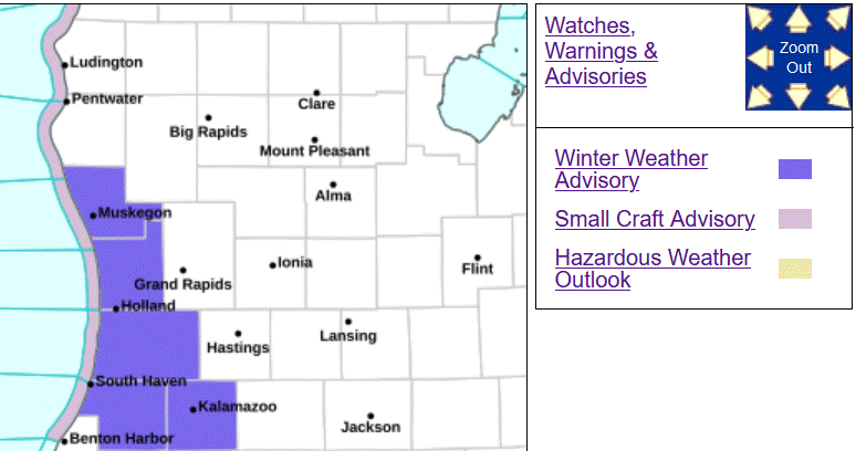
A Winter Weather Advisory is in effect from 8 am this Friday until 4 am Saturday. Everyone should see some snow during the day. It may not be snowing in the early morning, but the coverage of snow will increase in the midday/afternoon. Snowfall in the white colored counties on the above map will be 1-3” total through Saturday morning. In the purple counties, we should see up to 3-5” of snowfall.
Temperatures will stay a little below freezing all day and snow will stick to lesser-traveled side streets and rural roads and even on the main roads and expressways at times, especially in the purple counties. Driveways, parking lots and sidewalks will have slippery spots.
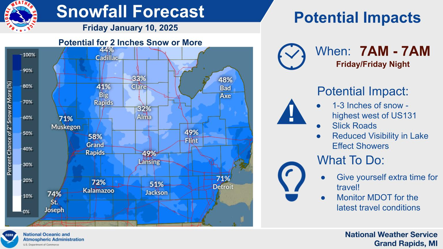
Here’s a map showing the % chance of 2” of snow today/tonight, with the highest chance in the lakeshore counties and Kalamazoo County and the lowest chance from Alma up to Mt. Pleasant and Clare.

We’ve had 8 days in a row with temperatures in the 20s. The cold pattern has resulted in ice forming on area rivers. We’ll be monitoring river gauge stations as ice jams are possible and they may cause fluctuations in river water levels. Fortunately, no big storms (heavy rain) are expected in the next week.
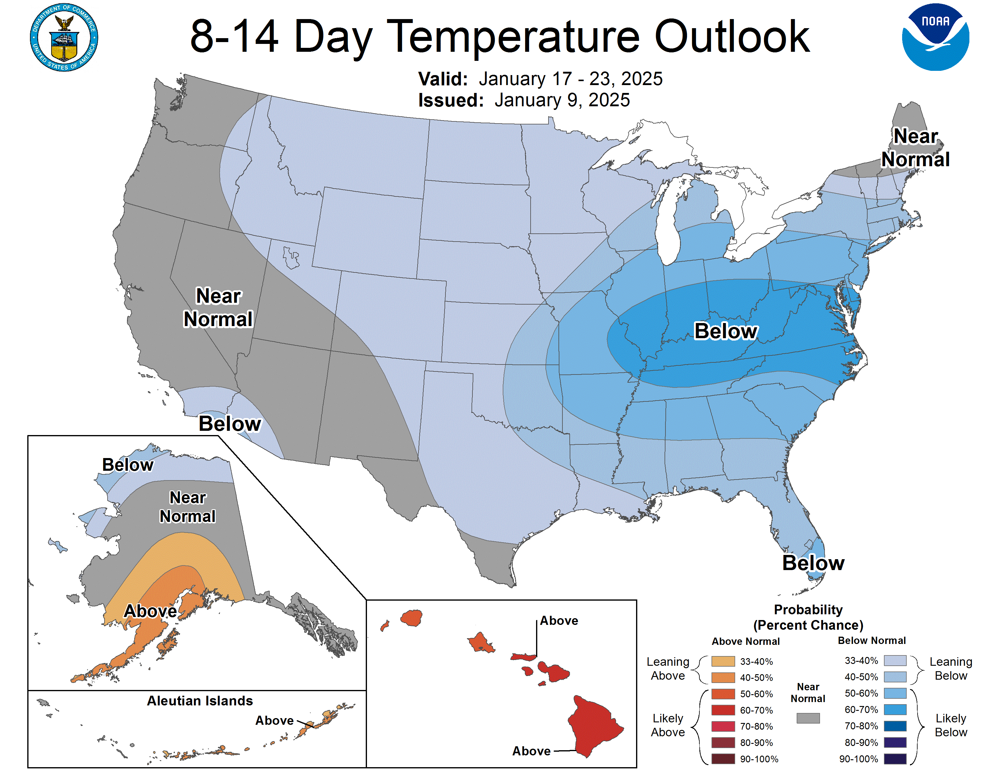
The latest 8-14 day outlook continues the cooler than average pattern for the next 2 weeks.
Here’s the latest Grand Rapids National Weather Service Forecast Discussion.
**********************************************************************************************************
This map shows areas still under a Red Flag Warning. The good news is that winds should generally be lighter over the next couple days in most areas. However that are local places (high mountain areas and mountain passes) where there are still strong winds. Check out how variable the winds have been overnight in southern California:
SOUTHERN CALIFORNIA WEATHER ROUNDUP
NATIONAL WEATHER SERVICE OXNARD CALIFORNIA
1100 PM PST THU JAN 09 2025

NOTE: "FAIR" INDICATES FEW OR NO CLOUDS BELOW 12,000 FEET WITH NO
SIGNIFICANT WEATHER AND/OR S TO VISIBILITY.

  -  STATIONS PRECEEDED BY AN ASTERISK (*) ARE NOT NWS OR FAA
     STATIONS AND ARE NOT SUBJECT TO NWS AND FAA QUALITY CONTROL.

CAZ041-042-087-100800-
LA AND ORANGE COUNTY COASTAL AREAS


CITY           SKY/WX    TMP DP  RH WIND       PRES   REMARKS
L.A. DOWNTOWN    N/A     50  19  29 N6          N/A
L.A. AIRPORT   PTCLDY    54  31  41 CALM      30.23R
LONG BEACH     CLEAR     53  32  44 NW5       30.20R

CITY           SKY/WX    TMP DP  RH WIND       PRES   REMARKS
FULLERTON      CLEAR     65  15  14 E15G22    30.21R
HAWTHORNE      CLEAR     51  33  50 N3        30.23R
*LEO CARRILLO    N/A     58  50  74 E5G21       N/A
*LOS ALAMITOS  CLEAR     68   7   9 E18       30.17R
SANTA ANA      CLEAR     69   9   9 NE13      30.21R
STA MONICA APT CLEAR     51  29  42 N5        30.23R
*STA MON PIER    N/A     59  29  31 E1        30.17R


CAZ547-548-048-100800-
LA COUNTY VALLEYS AND INLAND EMPIRE


CITY           SKY/WX    TMP DP  RH WIND       PRES   REMARKS
BURBANK        CLEAR     57  12  17 CALM      30.23R
VAN NUYS       CLEAR     60   9  13 CALM      30.23R

CITY           SKY/WX    TMP DP  RH WIND       PRES   REMARKS
CORONA AIRPORT CLEAR     66   9  10 SE8G21    30.24S
CHINO          CLEAR     65  10  11 E13G28    30.23S
MARCH AFB      CLEAR     49  10  20 N3        30.24R
*NORTHRIDGE      N/A     66   3   8 N7G20       N/A
ONTARIO        CLEAR     65   6  10 NE36G58   30.20S
RIVERSIDE      CLEAR     64   7  10 VRB3      30.26R
SAN BERNARDINO CLEAR     66   2   8 NE16G31   30.25R
*SAN RAFAEL HI   N/A     60   5  11 N3          N/A
*SAUGUS          N/A     60  11  14 N12G25      N/A
*WHITEMAN AP   NOT AVBL
*WHITTIER HILL   N/A     62   7  11 CALM        N/A
*WOODLAND HILL   N/A     41  39  93 CALM        N/A


CAZ054-055-100800-
LA AND SAN BERNARDINO COUNTY MOUNTAINS


CITY           SKY/WX    TMP DP  RH WIND       PRES   REMARKS
*BIG BEAR AIRP CLEAR     32   7  34 E17       30.39R WCI  21
*CHILAO          N/A     46   2  16 NE37G63     N/A
At the top, the wind at 11 pm local time at LAX (Los Angeles Intl. Airport) was calm. However the wind at Chilao was northeast at 37 mph with a peak gust of 63 mph. At Ontario CA, the wind was 36 mph with a peak gust of 58 mph and a relative humidity of just 10%. Most of the current fire areas should see winds of 10-20 mph this Friday.
From Dr. Ryan Maue on facebook: “100% of Santa Ana Wind event fires in Southern California are "human caused" and have little to do with climate change. Instead, acres burned - dependent upon wind intensity and the number of fires ignited, e.g., arson, powerlines, accidents, etc.”
The worst wildfires are started by people. Human-triggered California wildfires more severe than natural fires. Nearly 85 percent* of wildland fires in the United States are caused by humans.

Here’s current reservior levels in California. Most reservoirs are near or a little above their historic average levels for January.
This winter, southern California has been very dry and northern California has been very wet. Eureka in northwest California has had 26.27” of rain since October 1, compared to an average of 17.37” for that period. San Francisco has had 8.68” of rain since October 1 and that’s 0.55” above average for that period. BTW, San Francisco tied a daily record high temperature yesterday (Thu.) at 71 degrees. That reading was also reached on 1/9/1962.
Bill, thanks for pointing out the origin of most US wildfires. In a densely populated area like LA County there are fire hazards everywhere. BBQ’s, backyard bonfires, power lines, auto accidents, careless smokers, etc. I was saddened to see some of our media outlets blame this fire on global warming. SoCal has always had, and most likely always will have, Santa Anna winds and a very dry season. I hope the conditions stay favorable for the fires to be fought back. Very sad situation.