
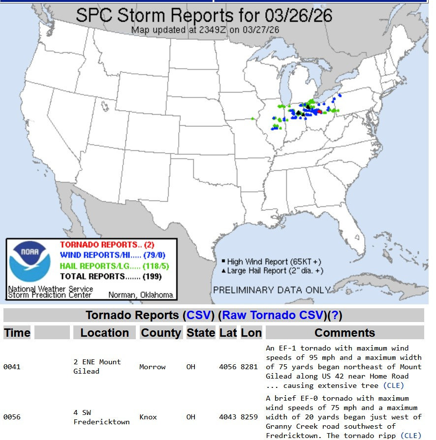
Severe Storms hit IL, IN, OH
No tornadoes, but dozens of reports of wind damage and hail

Here’s severe storm reports from the Storm Prediction Center for March 26-27 (7 am to 7 am). First, SPC did a nice job with their Enhanced and Slight Risk Outlooks for Thursday. Their outlooks gave all of us an excellent heads-up with where the severe weather was going to be Thu. afternoon and evening. There will still be a few more severe reports to add to the map.
Two tornadoes were confirmed in north central Ohio. One was rated EF0 and the other EF1. There We had 199 severe reports, 118 reports of severe hail and 66 reports of wind damage. I count at least 4 places were roofs were at least partially blown off and a couple places on I-69 where semis were blown over. Baseball-sized hail fell at Mt. Etna IN, with 2” diameter hail at Bryant and Holgate IN.
There was a report of 3/4-inch diameter hail at Burlington MI in Calhoun Co., south of Battle Creek.
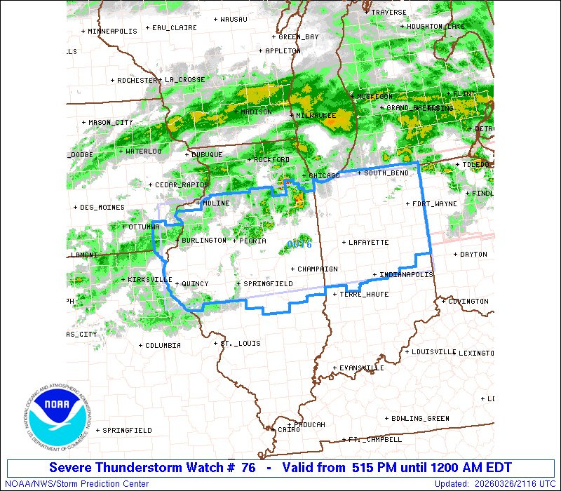
This was the Severe Thunderstorm Watch that was in effect for parts of Illinois and Indiana. Note: Radar will not automatically update on this graphic. Here’s a link to current radar. SPC wrote: “Primary threats include...Scattered damaging winds and isolated significant gusts to 80 mph likely. Scattered large hail and isolated very large hail events to 2.5 inches in diameter likely. A tornado or two possible.”
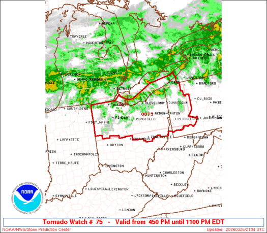
This was the Tornado Watch. It covered much of Ohio and western Pennsylvania. This was for the chance of an isolated tornado and the threat of large hail and strong winds.
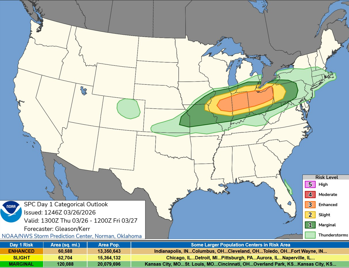
Thursday PM there was a Level 3 or Enhanced Risk (in orange on the map above) from Illinois across much of Indiana and Ohio.
This was surrounded by a Slight Risk (in yellow on the map above) across southern Lower Michigan. This was generally for areas south of a line from Benton Harbor to the Detroit area. This was a level 2 Risk.
Then there was a Marginal Risk Area (level 1) which came up to Holland to Grand Rapids to Flint.
The Storm Prediction Center said: “Current expectations are for thunderstorms to quickly develop along the length of the front from central IL eastward into IN, southern Lower MI, and northern OH by 3 - 6 pm. ”
The further south you are the better the chance of a storm…with the best chance of a severe storm across northern Illinois, northern Indiana and northern Ohio. In Michigan the most likely area to see a thunderstorm was south of I-94.
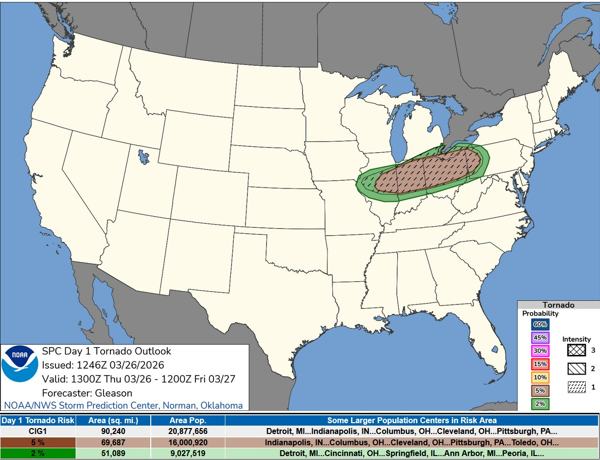
Here’s the Tornado Risk Map from SPC. The greatest threat of a tornado will be in the brownish area just south of the Michigan border in Indiana and Ohio. SPC says: “There is a threat for a few tornadoes as well with both supercells and embedded mesocirculations within the linear clusters.
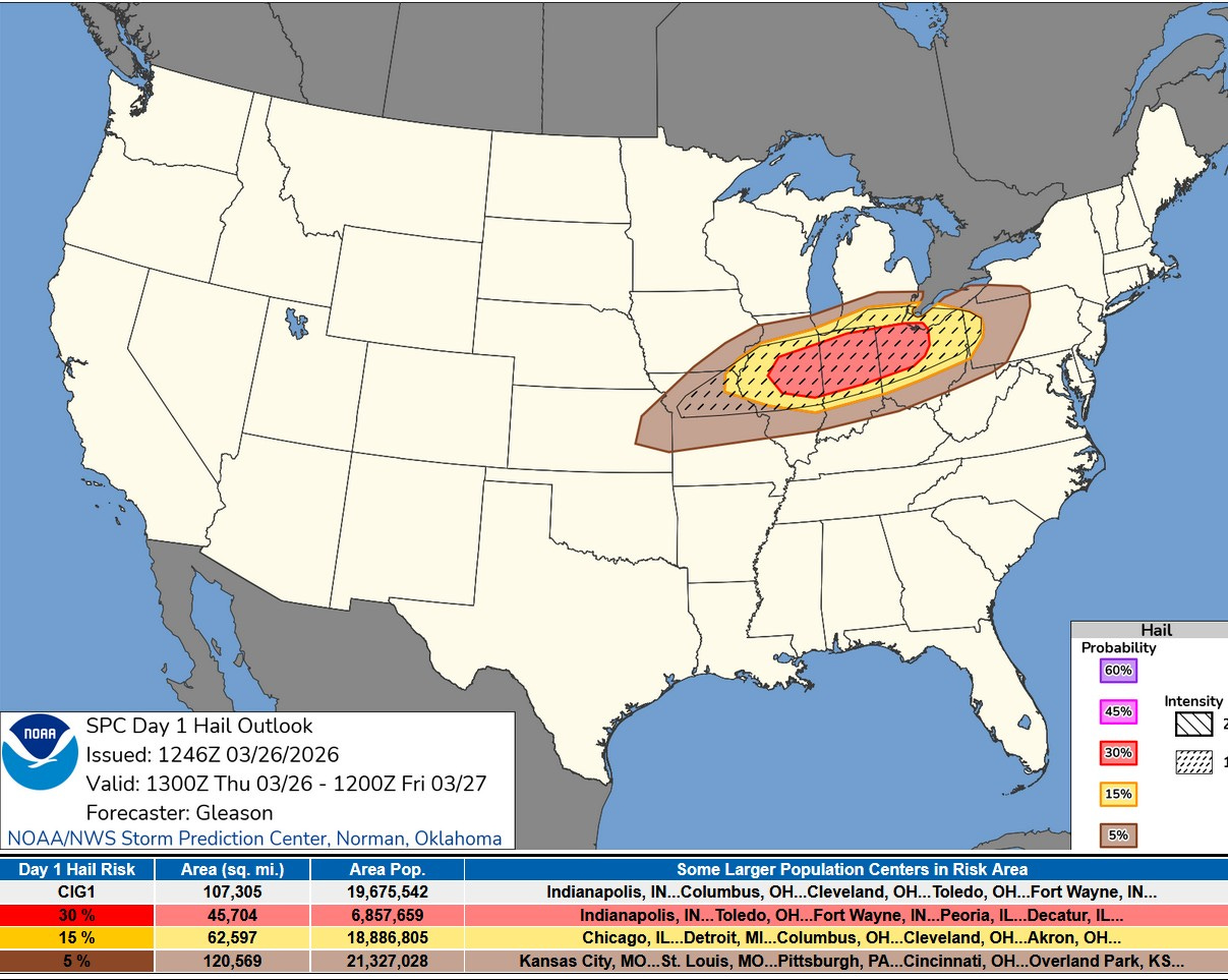
This was the Severe Hail Outlook for Thu. PM/night. The greatest threat is from Illinois across Indiana into Ohio. The red area indicates a 30% chance of a severe hail report within 25 miles of a given point. SPC said: “Large to very large hail (2+ inches in diameter possible) should occur as long as a supercell mode can be maintained.” Southern Lower Michigan will likely be on the cool side of the boundary.
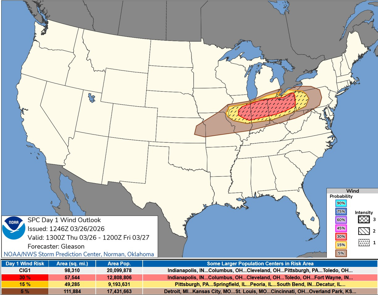
This is the Severe Wind Forecast from SPC. Again, the greatest risk will be in that same area across IL/IN/OH, with a smaller wind risk in far southern Lower Michigan. The wind risk was very low in the cool air north of I-96. SPC said: “…an increasing threat for scattered to numerous severe/damaging winds as one or more clusters spreads east-southeastward across much of the OH Valley into western/central PA through the late afternoon and evening. Given the forecast strength of the low to mid-level flow, isolated gusts of 75+ mph may occur.”
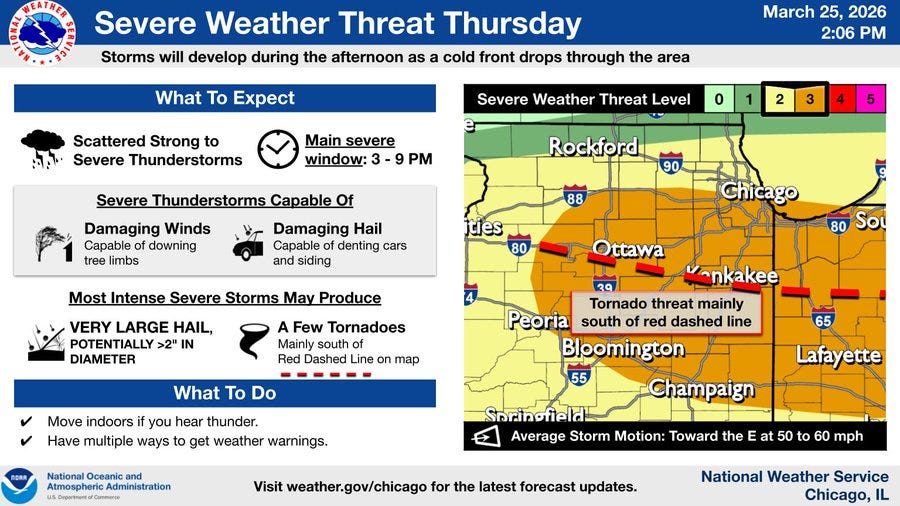
Here’s the Chicago NWS graphic on the storms this PM. Note the red dashed line with the greatest tornado threat south of that line. Large hail might be most likely just north of that dashed line.
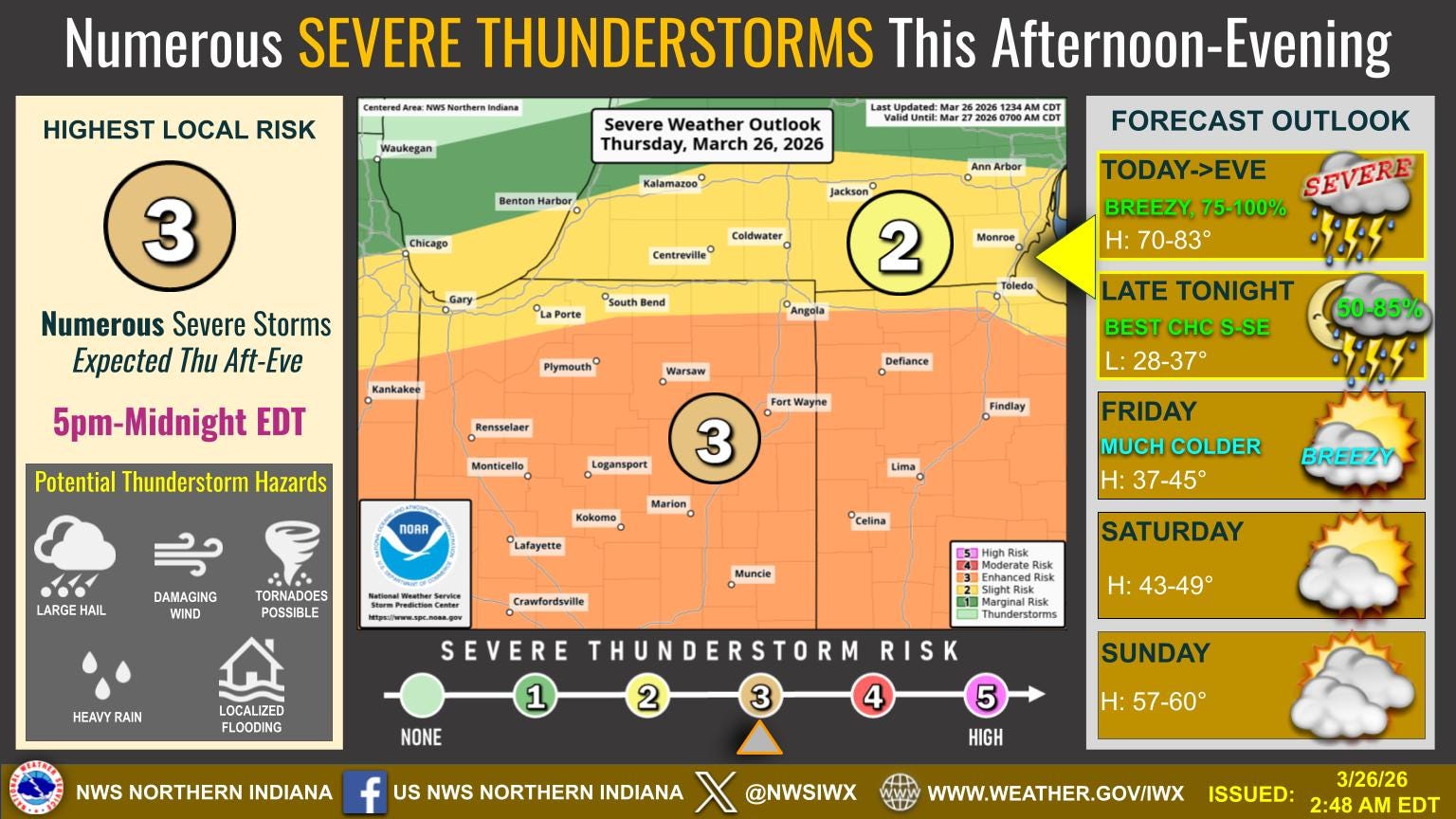
This graphic is from the Northern Indiana NWS. Note the timing, 5 pm to midnight and the thunderstorm risk levels across the area (Slight Risk along and south of I-94.
Also, there were Gale Warnings for Lake Michigan until 5 am this Friday AM for gusts to 30-40 mph and waves up to 5-9 feet. Be careful venturing out on piers and breakwalls as waves are choppy on the lake today.
At 12:45 pm, the temperature in downtown Chicago (water intake) was 63 with a west wind at just 6 mph, while the temperature 30 miles to the north at Waukegon was just 40° with a northeast wind off Lake Michigan at 20 mph. That cold air is headed south. The temperature at Wrigley Field (home opener for the Chicago Cubs was Thursday PM) fell about 20 degrees.
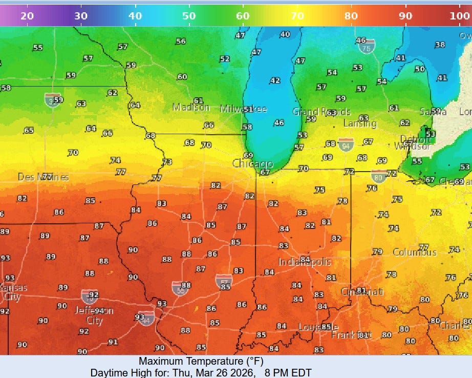
The map above shows forecast high temperatures for Thu. PM. Look at the 80s across much of Indiana and Illinois…82 for Kankakee IL and Rensselaer IN and 93 for St. Louis! Much cooler to the north with highs expected to be in the mid 40s at Ludington and Houghton Lake.
NOTE: The Chicago Cubs opener was Thursday PM. They started at 1:20 CDT. I think they can get the game in. Big temperature difference…Wrigley Field may be 45 degrees with an east wind off chilly Lake Michigan, while it may be in the 70s in the far southwestern Chicago suburbs. No baseball-sized hail at the ball game, though!
The Detroit Tigers will have no problems in San Diego, where it will be in the mid-upper 70s during the game. I saw a game in San Diego - very pleasant evening.
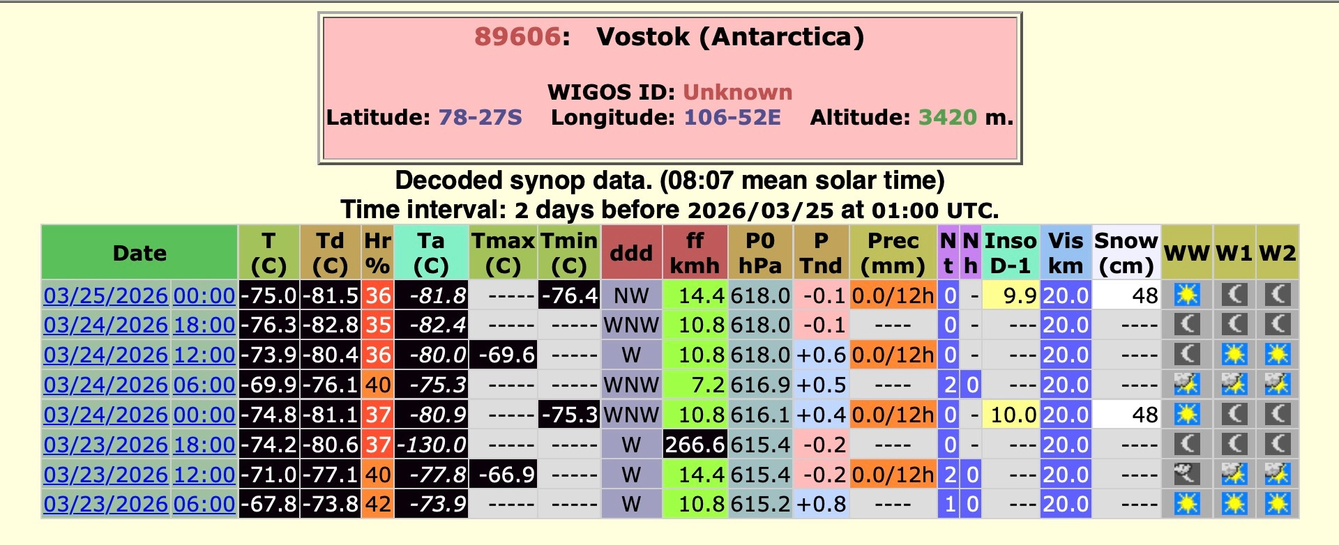
Shiverin’ Snowman! There was an all-time March record low temperature for the continent of Antarctica. The low temperature at Vostok dipped to -105.5°F or -76.4°C
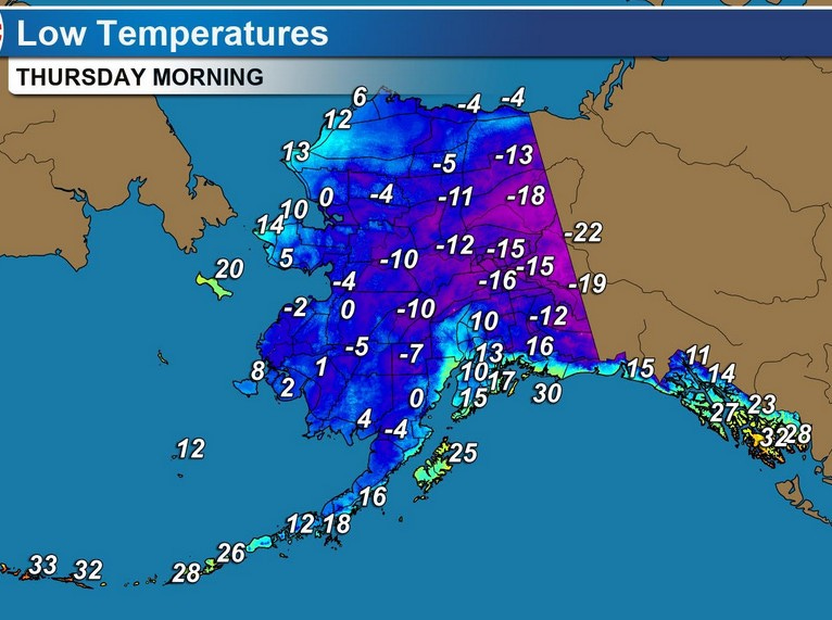
And…we’ve seen more record cold in Alaska and northern Canada. Here’s low temperatures expected this Thursday AM.
Fairbanks has had an average temperature of -12.9 degrees this month of March and that’s 21.6 degrees colder than average! They’ve had 7 days this month with low temperatures of -40° to -50°.
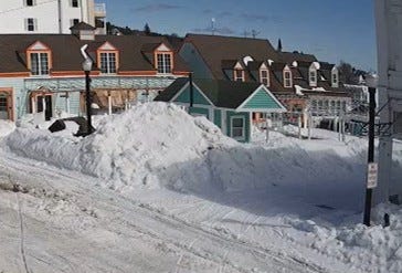
The pic. above is Main Street on Mackinac Island Monday afternoon (Horn’s Bar webcam). They do plow Main Street and they’ve got some pretty big piles there. I was watching the webcam and I saw an occasional snowmobile go by, people walking, walking dogs and on rare occasion, a horse drawn cart. The temperature at noon on Mackinac Island Tue. was a cool 30 degrees.
Enjoy reading your column! Thank you for sharing it!
In Vicksburg area.
I'm so glad I can see green and have NO SNOW! Snowdrops, crocus and daffodils blooming!