
Wet, Warm and Windy
Potential for additional flooding and isolated severe weather this week

Happy Sunday. This week will be quite wet, with much of West Michigan getting 1-3” of rain. It will also be relatively warm, with temperatures running a good 10-15 degrees warmer than average (the average high temperature is now 56). It’s also going to be windy, with a S-SW wind at 15-25 mph with gusts to 30-35 mph. The southwest wind will keep it a little cooler near Lake Michigan.
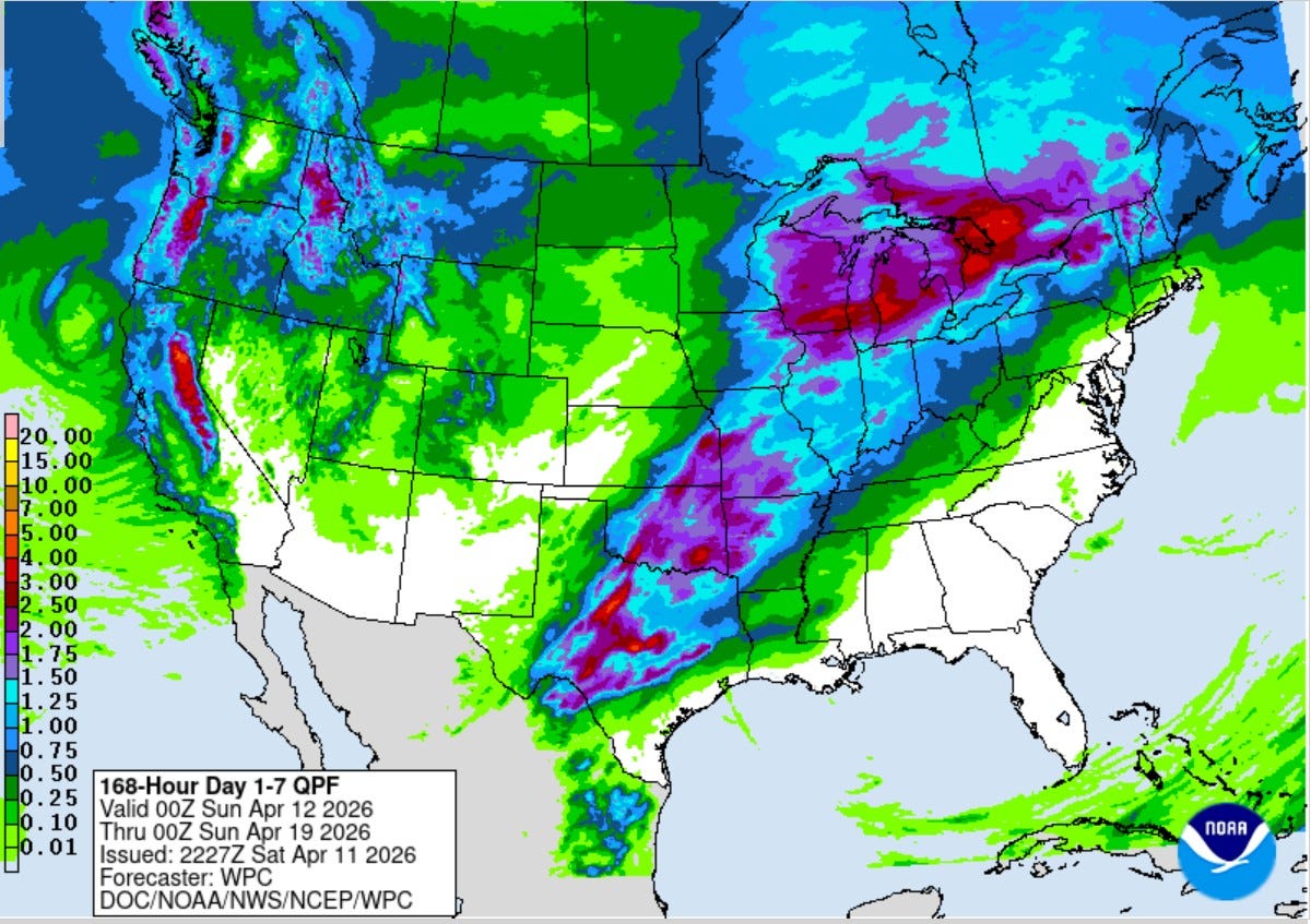
This is the 7-day combined rainfall total forecast from the Weather Prediction Center. Some of the heaviest rain in the U.S. will fall in West Michigan this week. A front will move back and forth, bringing successive rounds of rain and storms from Texas to the Great Lakes.
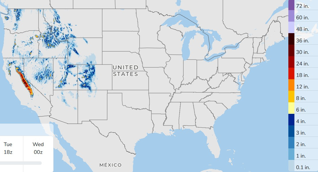
Here’s the 66 Hour snowfall forecast. Note there is none forecast east of the Rockies - too warm for snow. The snow in the higher elevations out West is welcome as they are below average for snowfall this winter. The Sierra Nevada mountains of California should see heavy snowfall totals this week, measured in feet, not inches.
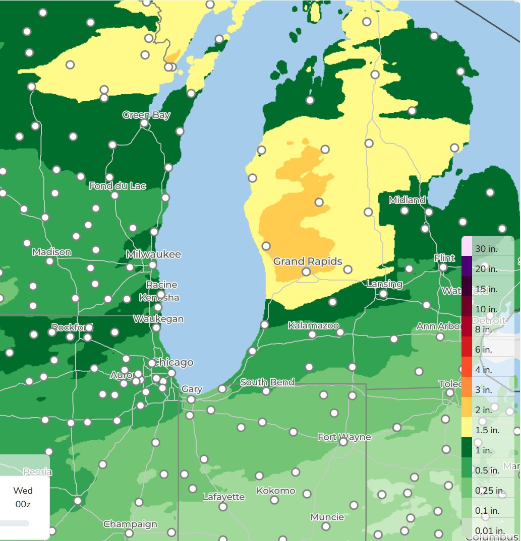
Here’s 66 Hour Rainfall. Note there is less rain south and more north. That’s about 1/4” for Fort Wayne, 1/2”-3/4” for South Bend and Coldwater MI. and 3/4” - 1” for I-94.
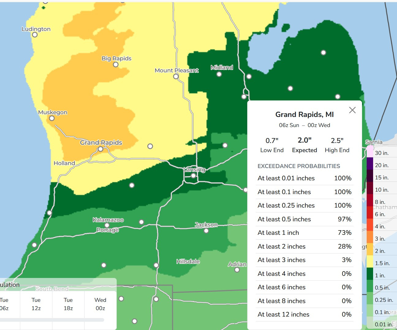
Here’s a close-up map of expected rainfall from Sunday - Tuesday. Grand Rapids gets around 2”. The +2” area extends to the north toward Cadillac. The Grand River begins down near Hillsdale and rainfall totals won’t be quite as high there. However, if this map verifies, this means significant rain on the Muskegon, White, Pentwater, Pere Marquette and Manistee Rivers.
After Tuesday, periods of rain and storms may continue until next weekend. It won’t be raining all the time. In fact, most of the time it won’t be raining, but this will be a week to keep an umbrella handy.

We had a light offshore wind Saturday, so Lake Michigan was pretty calm. This pic. shows the Muskegon Channel in the early morning. I count 7 boats in the water in this pic. from the Muskegon Glerl camera. I would assume they were fishing boats.
Today and tomorrow will be breezy with a southwest onshore wind that could gust to 30 mph. Small Craft Advisories are in effect through Monday afternoon.
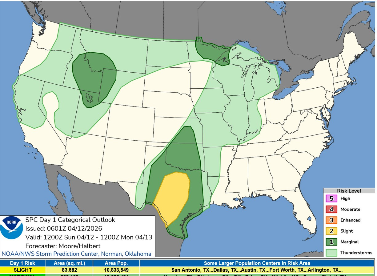
Here’s the Severe Weather Outlook map for this Sunday PM. Michigan is in the light green “General” Thunderstorm Outlook Area. So, while we might get a thunderstorm, it’s unlikely to be severe. There is a Slight Risk (level 2) in Texas and Marginal (level 1) outlooks in the Rockies and across parts of northwest Wisconsin and northern Minnesota.
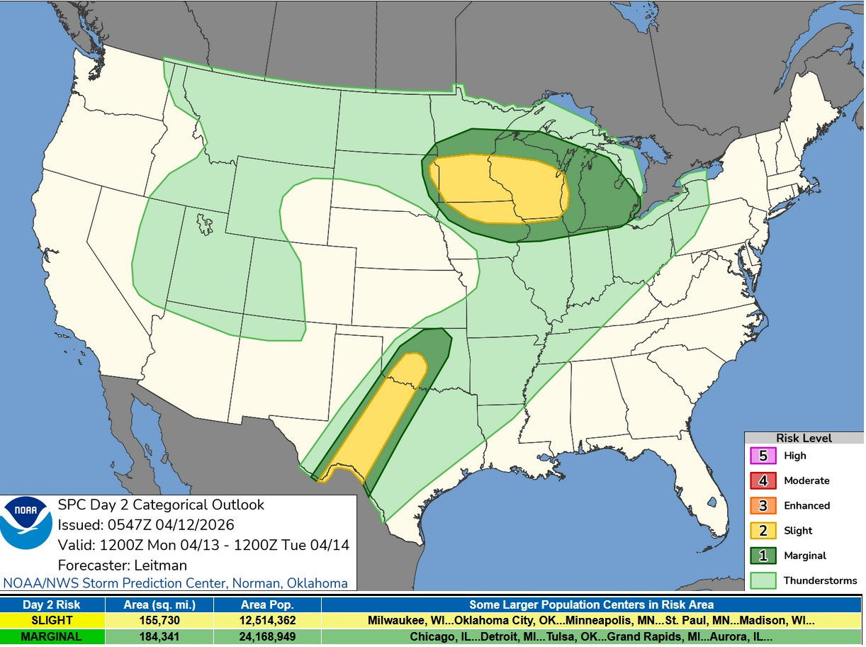
This is the Severe Weather Outlook Map for Monday. Most of Lower Michigan is in the level 1 or Marginal Risk Area, mainly for isolated strong wind. SPC says: “…supercells capable of all hazards will be possible. While this evolution is uncertain, it appears most probable from southeast MN toward south/south-central WI. Convection will spread eastward with time into MI, continuing to pose a risk for hail overnight.”
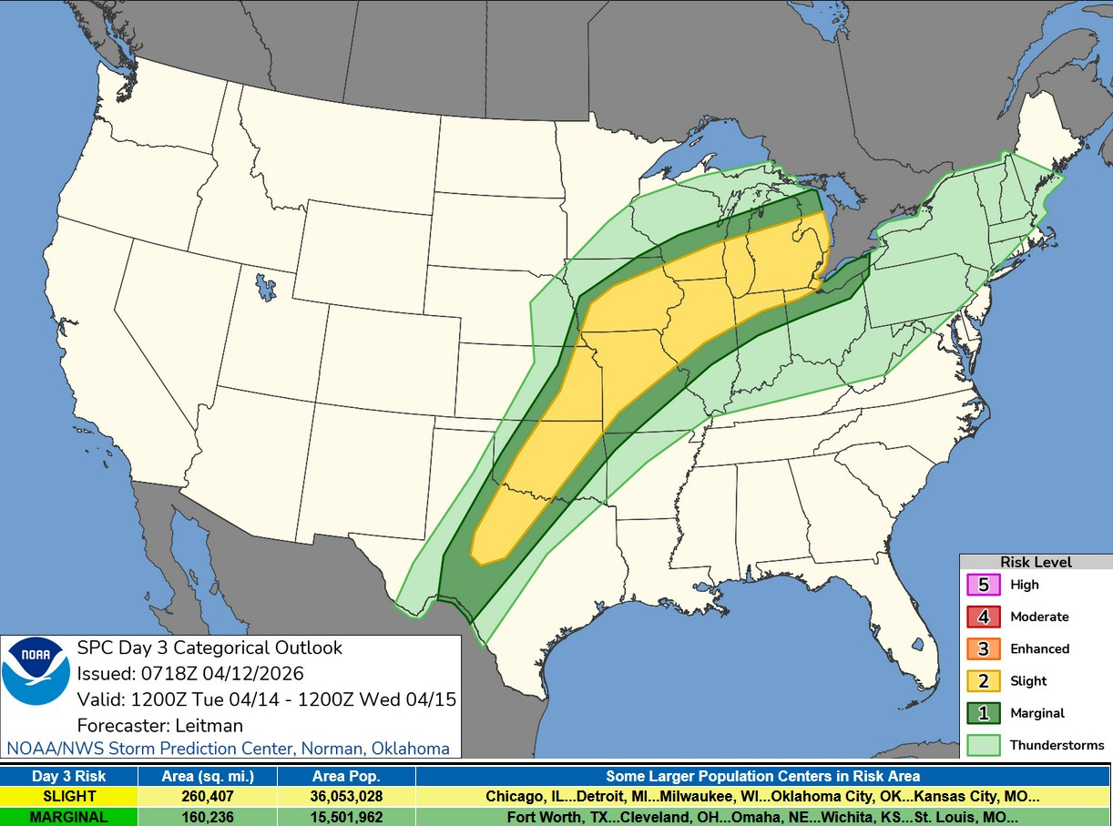
This is the Severe Weather Outlook Map for Tuesday/Tuesday night. This looks like our best chance of a strong to severe storm. The yellow area is a Slight Risk (level 2) and that runs from Texas to Ontario. SPC says: “…surface boundary should support isolated to scattered storm development by late afternoon/evening. Supercell wind profiles are evident in forecast soundings, suggesting an all-hazards risk. Given uncertainty related to potential airmass contamination from early day convection and cloud cover, and potential capping concerns, will maintain Slight risk (level 2 of 5). However, a rather volatile thermodynamic and kinematic environment will exist across portions of the region, and higher probabilities may be needed in subsequent outlooks depending on forecast trends and mesoscale details.”
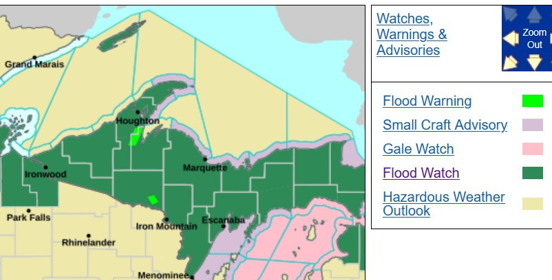
A Flood Watch has been posted for all of Upper Michigan and 3 counties in northern Lower Michigan where there is still snow on the ground (Emmet, Cheboygan and Presque Isle). A combination of snow melting and moderate to heavy rain could cause flooding this week in the U.P.
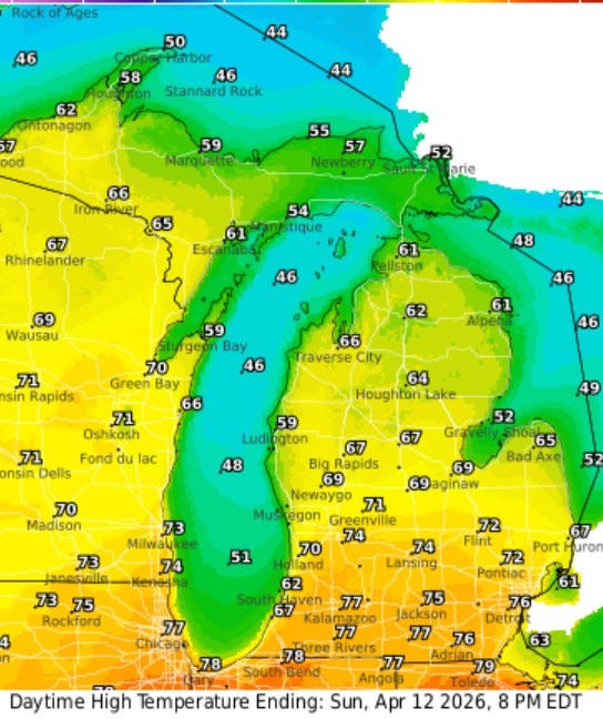
Here’s forecast high temperatures for this Sunday in Michigan. It’ll reach the upper 70s south of I-94, low to mid 70s up to Grand Rapids, 60s north of Kent County where there will be more clouds and showers. The warm air surges north and readings should reach the 50s even up at S. Ste. Marie and Munising.
It will be cooler near Lake Michigan…62 at S. Haven, 59 at the Ludington Airport.
Also: Volcano erupts in Japan. Tornado in India. Hailstorm in Turkey. Flooding in Saudi Arabia.
Sounds like Spring is here. Check the batteries in the flashlights, charge up the power banks, and make sure your sump pump is working.
Thanks Bill!!