
Warming Trend
Temperatures head up into the 30s today (Sun.), then 40s for Monday - Wednesday

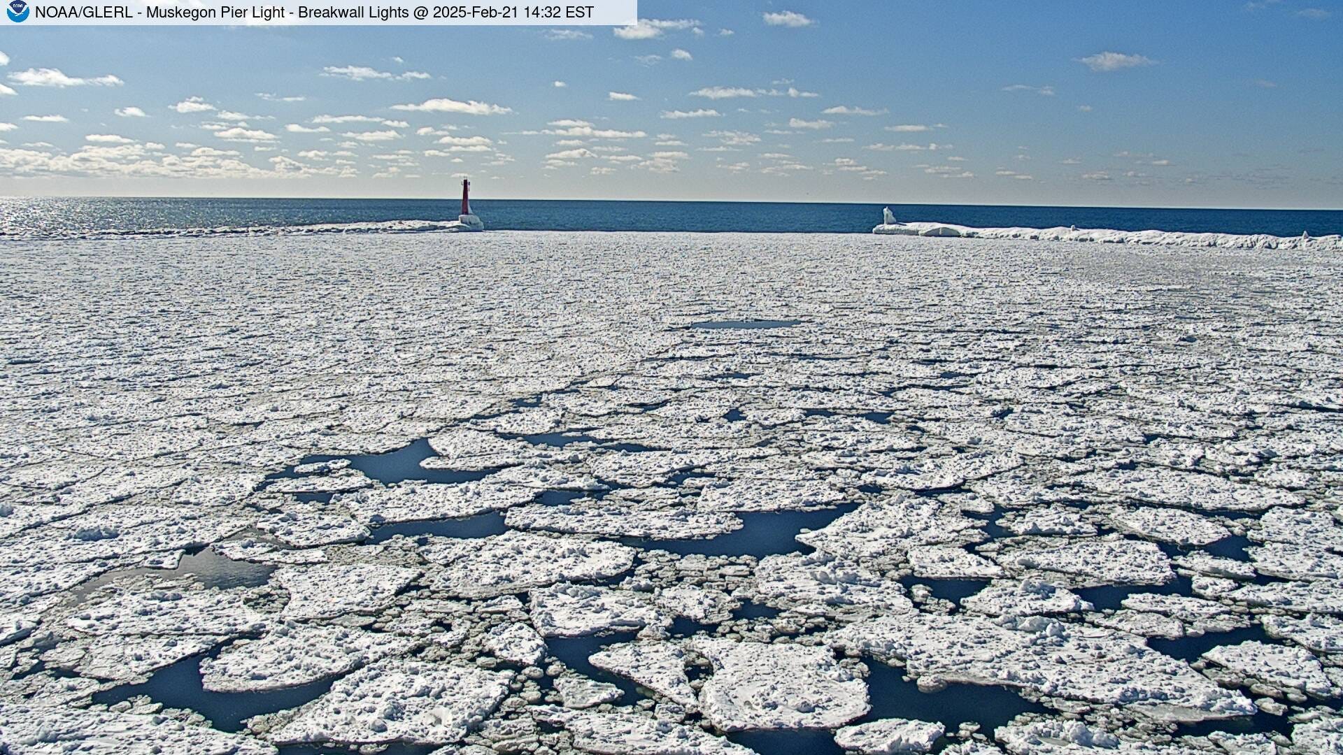
The past two days (Fri. and Sat.), we’ve had 87% and 65% of possible sunshine. That’s the two sunniest back-to-back days since Nov. 7-8, 2024. Since November, Grand Rapids has had 25% of possible sunshine. Th picture above is the Muskegon Channel Friday PM (21st).

We’ve also had 15 consecutive days with below average temperatures. So far (through Saturday), the month of February is averaging 4.2 degrees colder than average. In January, Grand Rapids was 2.6 degrees colder than average. So far, the warmest temperature of February in Grand Rapids has been 37.
February of last year (2024) averaged 8.8 degrees warmer than average. So that means this February is averaging 13 degrees colder than last February - a big difference. Final figures aren’t in, but it looks like January 2025 may be the coldest January since 1994 and the winter season (Dec. - Feb.) may be the coldest since 2010-11. This is according to the USHCN data (that’s the United States Historic Climate Network). This is a set of weather stations that have a long record and where there has been little change in environment around the weather station.

The pic. above is Bittersweet Ski Area Saturday PM. It’s been a pretty awesome winter for winter sports. Today (Sun.) should be another great day to get out the skis or snowboard.

This was the Muskegon Winter Sports Complex skating rink Saturday PM. Lots of people having fun. This is where the luge is located and where you can skate through the woods.
Here’s some season snow totals from northern Lower Michigan and Upper Michigan. Five locations are already over 230% for the winter season. No location got past 173” last winter. Gaylord is up to 181.6” and S. Ste. Marie has had about 170”. That’s more than five feet above their average-to-dat.
Grand Rapids is up to 62.1” for the winter. Holland is at 76.8” and Muskegon is close behind at 73.5”. Lansing, farther away from Lake Michigan, has picked up 37.5” for the season. Our snow has been mostly light, fluffy lake-effect snow.
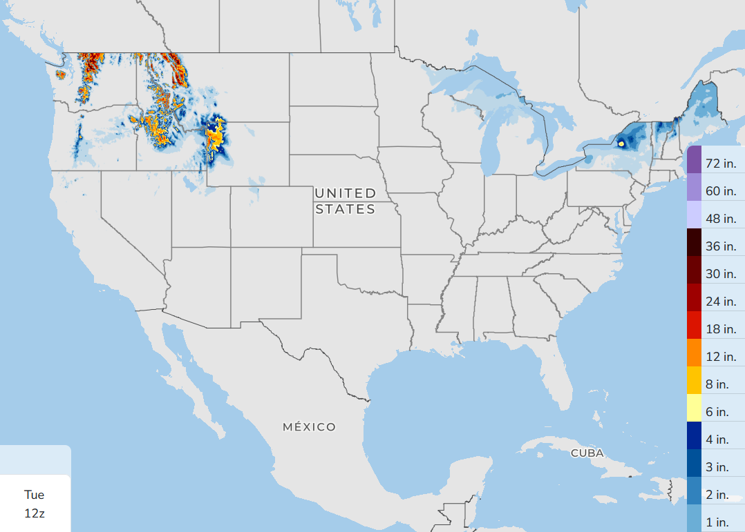
The map above shows expected snowfall for Sunday through Tuesday. None for Lower Michigan and maybe a dusting for the U.P. Heavier snow will fall in the mountains of the Pacific Northwest and thr will be some snow in northern New England.


Great Lakes ice extent may have peaked for this winter. It rose quickly with the cold air last week, then dipped sharply on Saturday as strong winds, especially on Lake Superior, broke up the ice. The peak Friday of 52.23% is exactly at the 52% average peak ice on the combined Great Lakes. Lake Michigan peaked at 33.46%, again very close to average.
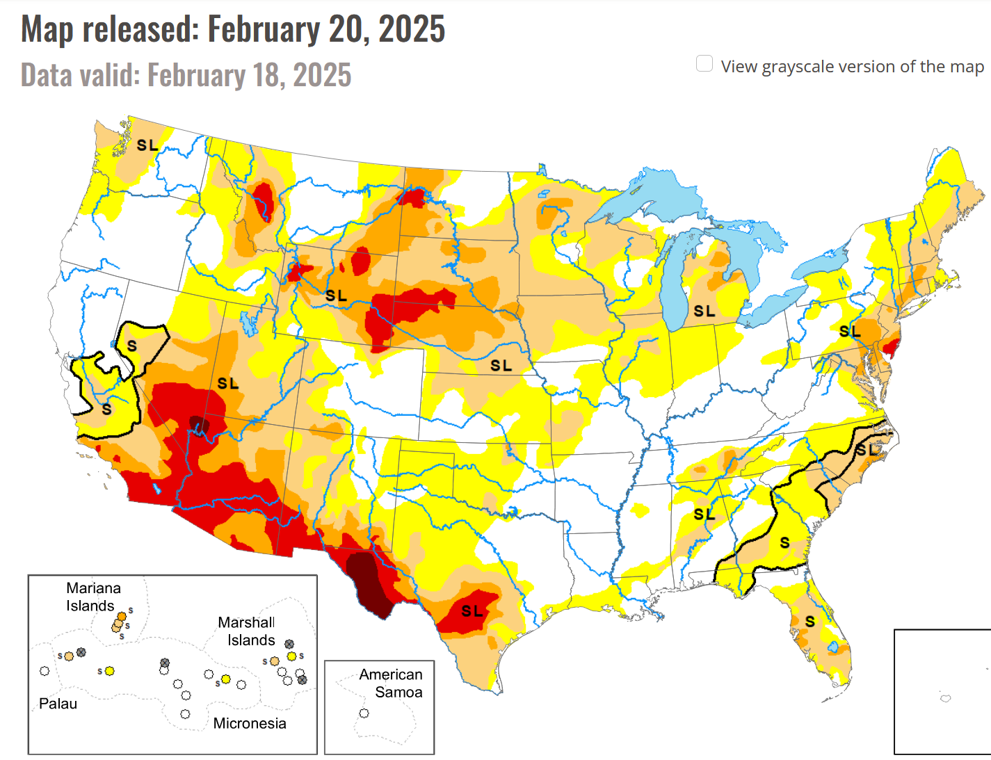
This is the latest drought monitor map. “S” is short term and “SL” is short and long term. It’s been an extremely dry winter in the Southwest. Since last July 1, Phoenix AZ has had only 0.03” of rain (less than 1% of average). San Diego has had 1.79” since July 1 or 19% of average. Los Angeles has had 41% of average.
Fortunately, northern California has had a lot of rain and that rain has kept the reservoirs in good shape. Eureka has had 33.75” of rain since July 1 and that’s 7.38” above average.

The latest 8-14 day temperature outlook calls for (slightly) below average temperatures in Michigan. However, keep in mind that the averages are climbing now. By the 7th of March, the average high temperature is 40, so a little below average would be mid-upper 30s.

This is the Thunder Bay Island Lighthouse Saturday afternoon. There’s ice near shore and open water beyond that. The island is roughly 215 acres.
From Wikipedia: “During the 1830s and 1840s, a commodity market in barrelled fish arose on Lake Huron. The fresh-caught fish was quickly brought to a fishing station after being caught, and salted for preservation. During this period, an 1846 gazetteer counted 160 settlers on the island and 31 fishing boats that called the island their home port. The total catch is said to have been 12,000 barrels of fish per year. The Thunder Bay Island fishing station supported a small general store.
After a few decades, however, the yield of Lake Huron fish declined. The Thunder Bay Island fishing station became a ghost town.
Here’s forecast high temperatures for this Sunday…mid 30s for West Michigan. Temperatures soar to the low 60s in central an western South Dakota. Rain and thunderstorms keep it cool along the Gulf Coast from Houston to New Orleans.
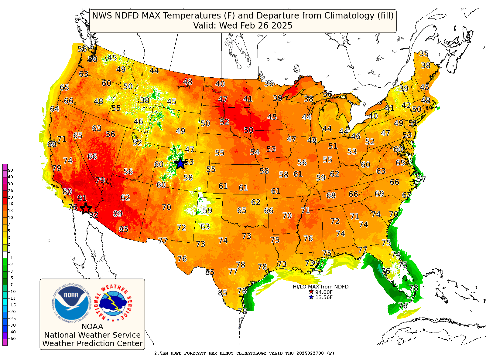
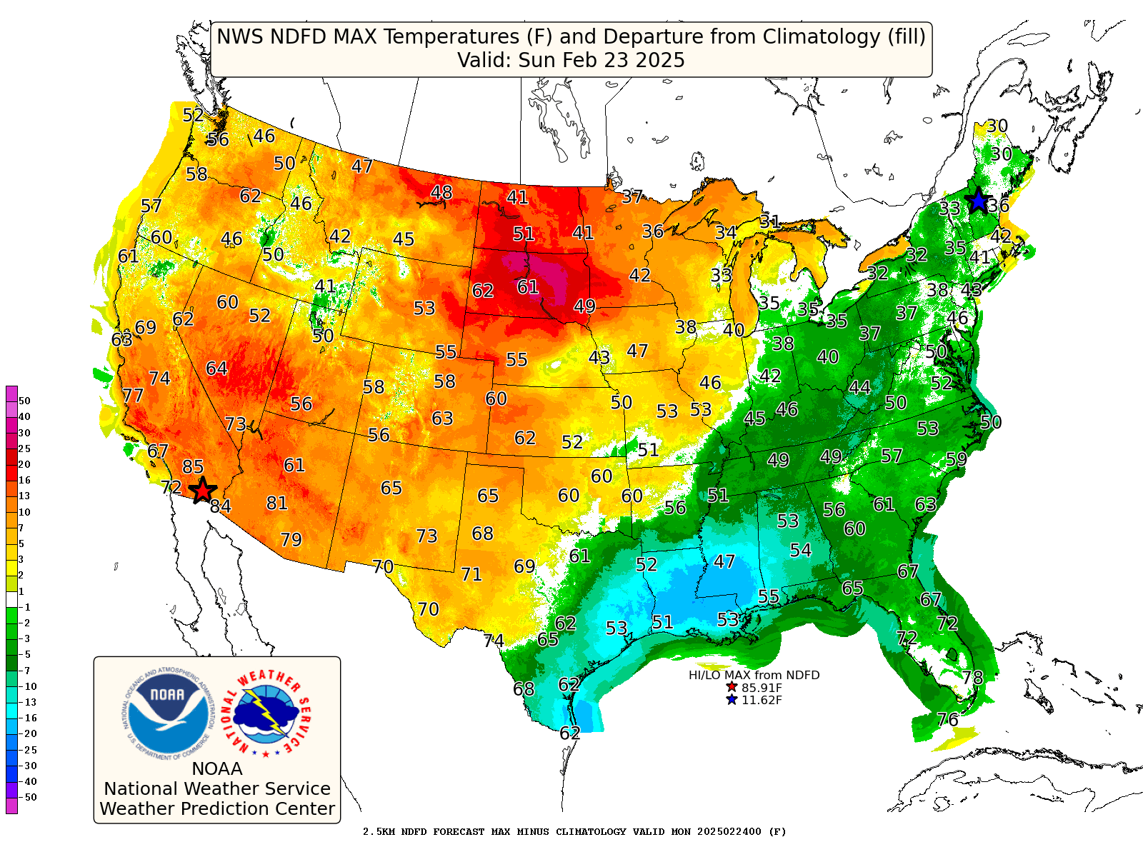
Here’s expected high temperatures for Wednesday 2/26. Look for coast-to-coast mild to warm air with mid 40s in southern Michigan, 62 in Louisville - low-mid 70s across the South. Quite a change from the cool pattern we’ve been in much of this month.

Finally, I was scanning webcams out West and saw that the Old Faithful geyser in Yelllowstone National Park was set to erupt in several minutes, so I stayed and grabbed this shot. I had the chance to see the geyser in person last summer while on a Holiday Vacations tour. It was awesome. I estimated 2,000 people were there when I saw it, sitting on benches.
The geyser erupts around 20 times a day. Eruptions last anywhere from 1.5 minutes to 4.5 minutes. Hot water (over 200 degrees F) can shoot over 150 feet into the air.
It’s actually not the largest geyser in the park. That’s the Steamboat geyser, which erupts much less often at irregular intervals. There was a 50-year period when it didn’t erupt at all.
Thank you for all the interesting information, charts, and pictures! I especially enjoy the historical perspectives :) It's nice to have my thoughts about this winter validated by facts. I'm so grateful that you're continuing to share your knowledge, thoughts, and stories with the public!
Chock full of excellent information! Thank you! Some of the data would indicate Spring might be setting in....just maybe! I just love looking at all the data.
Keep up the amazing work!