
Whoa! BIG upgrade in the Severe Weather Outlook for Sunday.
The Storm Prediction Center has significantly increased the chance of severe storms Sunday PM

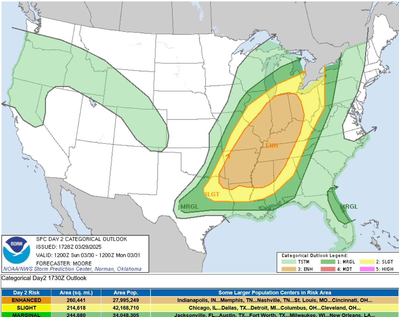
This is the Severe Weather Outlook Map for this coming Sunday, March 30th. WOW! BIG upgrade to the Severe Weather Outlook Area from the Storm Prediction Center for Sunday. We now have a large Enhanced Outlook (level 3) from South Bend down to northern Louisiana. The Slight Risk (level 2) covers all of southern Lower Michigan and the Marginal Risk Area is almost up to Traverse City.
SPC says: "A widespread/substantial severe-weather episode is forecast across an area centered on the Ohio/Mid and Lower Mississippi/Lower Missouri/Tennessee River Valleys. Very large hail, damaging winds, and strong tornadoes are expected."
SPC also says: "...convection may evolve into one or more bands of organized storms with embedded rotation, with risk for more widespread strong/damaging gusts, in addition to embedded tornadoes, as the convection shifts across Indiana/southern Lower Michigan, and eventually western Ohio through the evening and into the overnight."
The Gaylord NWS says: “CURRENT SOUTHWARD DRIFT OF LOW PASSAGE IN
GUIDANCE SUGGESTS ANY SEVERE COMPONENT WILL REMAIN OFF TO OUR SOUTH.” So, the chance of severe weather is now lower in Northern Lower Michigan with probably the best chance where the sun comes out in southern Lower Michigan, Illinois, Indiana and Ohio.
.
“Supercells are expected within this environment, and very large hail is expected given the cold air/steep lapse rates through the mid troposphere. Along with the hail risk, damaging wind gusts are expected -- particularly where upscale growth into bands occurs. Additionally, this setup appears very favorable for tornadoes, a few of which may be strong/potentially long-lived.”
The map above is the Severe Weather Outlook for this Friday. There is a Marginal Risk (level 1) in the dark green colored areas. The northern Marginal Risk Area runs from Nebraska northeast to northern Wisconsin. SPC says: “Gusty winds and hail are the primary concerns with this isolated activity.”
The light green indicates thunderstorms are possible in all of Michigan, but they are not expected to be severe.

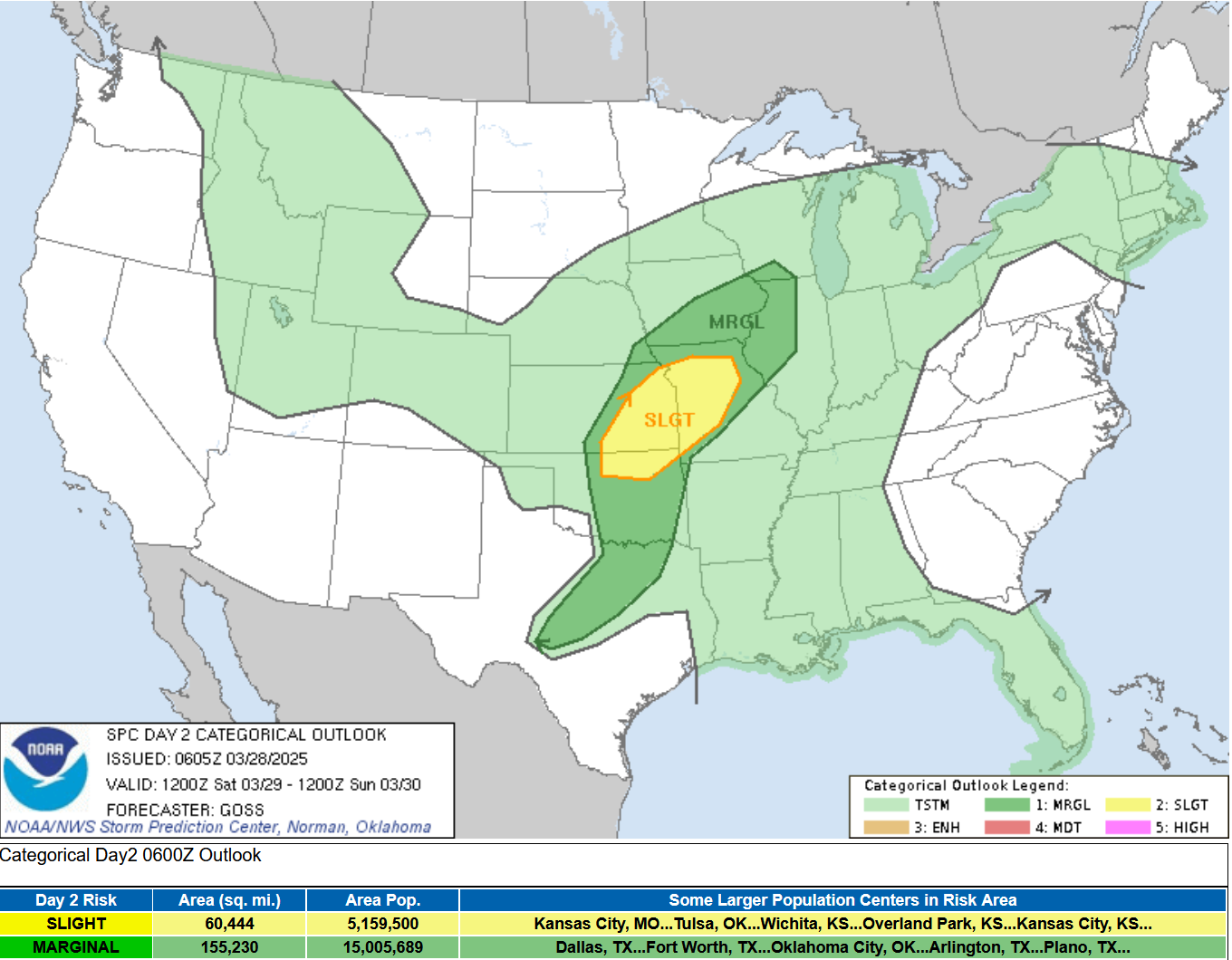
Severe Weather is also likely in the Midwest on Saturday, March 29. The Severe Weather Outlook for Saturday shows a Slight Risk (level 2) over southeast Kansas, northeast Oklahoma and western Missouri. Once again, there is a chance of a non-severe thunderstorm in Michigan.
And…below is the Severe Weather Outlook Map for next Wednesday. There is a large Risk Area that runs from east Texas to Michigan and Ohio. It covers areas south of a line from South Haven to the Detroit Area.
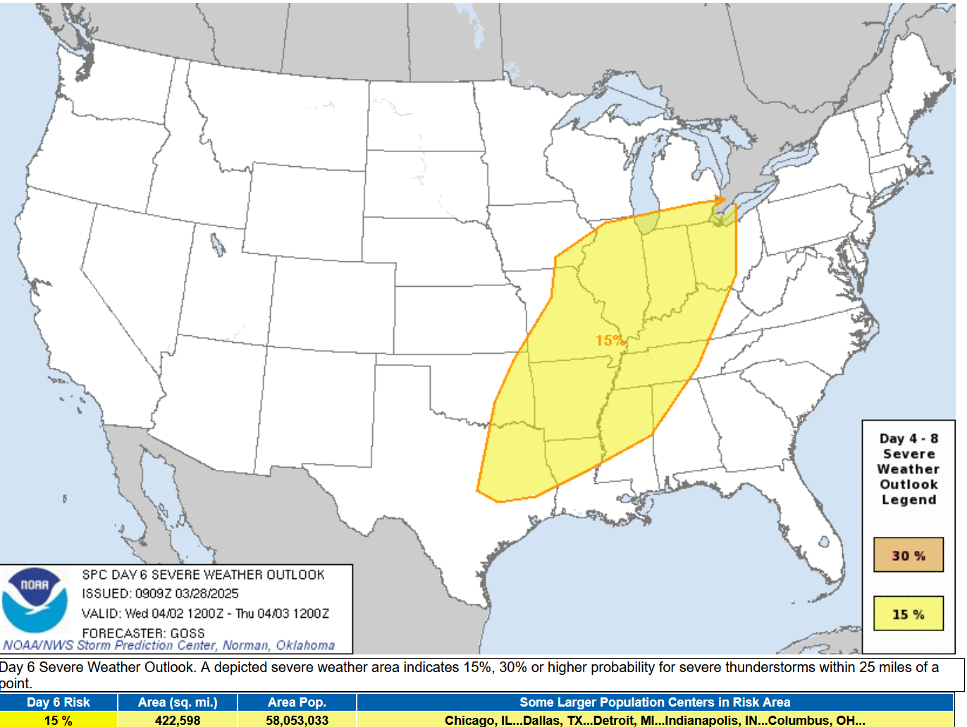
Regarding the severe threat next Wednesday (April 2), SPC says: “confidence is high enough to proceed with introduction of a broad -- though areally uncertain -- 15% area. This system would appear to have the potential to produce another fairly widespread/all-hazards severe event, but will likely require a good bit of adjustment over the next few days.”
Bottom line…West Michigan will get scattered showers and a possible non-severe thunderstorm this afternoon (Fri.) and tomorrow (Sat.). There’s a better chance of a strong to severe storm on Sunday and again next Wednesday.
And…an Ice Storm Warning has been issued for much of Upper Michigan…from Baraga and Marquette Counties east to Sault Ste. Marie. The NWS says:
...ICE STORM WARNING IN EFFECT FROM 5 PM THIS AFTERNOON TO 8 PM EDT
SUNDAY...

* WHAT...Significant icing expected. Total snow accumulations up to
  one inch and ice accumulations between one tenth and one half of
  an inch this evening through tonight. Additional snow and ice
  accumulations are possible Saturday night through Sunday.

* WHERE...Alger, Delta, Luce, Northern Schoolcraft, and Southern
  Schoolcraft Counties.

* WHEN...From 5 PM this afternoon to 8 PM EDT Sunday.

* IMPACTS...Power outages and tree damage are likely due to the ice.
  Travel could be very difficult to impossible. The hazardous
  conditions could impact the Friday evening commute.

* ADDITIONAL DETAILS...Ice accumulations up to a quarter inch and
  wet snowfall amounts up to 4 inches are possible Saturday night
  through Sunday. Keep your eyes on the forecast for any changes.

PRECAUTIONARY/PREPAREDNESS ACTIONS...

Travel is strongly discouraged. If you must travel, keep an extra
flashlight, food and water in your vehicle in case of an emergency.
Prepare for possible power outages.ALSO: Check out the video and pictures from the 7.7 magnitude earthquake in SE Asia.
With the cancellation of regular daily weather balloon launches across our entire country, how much longer are we going to be getting reliable weather prediction notices such as this one?