5 Tornadoes, +95 mph Winds Hit West Michigan
A peak gust of 80.55 mph was recorded Sunday evening at the Ford Airport.
WOW!!!!! - A measured gust to 81 mph at was recorded at the Ford Airport in Grand Rapids Sunday Evening. If this verifies, it could be the fastest measured gust EVER officially in G.R. I remember the Grand Rapids official record highest wind is a peak wind of 80 mph during the Armistice Day storm of 11/11/1940. That was not a thunderstorm wind in 1940, just strong winds around a low pressure system.
The G.R. Airport had a ground stop (no take-offs or landings) for a little while when the storm was blasting through. There were 3 planes waiting for the storm to pass to take off for Chicago. The control tower at the Ford Airport was evacuated for a short time during the storm.
Wowie Zowee!! Look at this! - a measured gust of 96 mph was recorded at the Jackson MI airport!
Also gusts to 80 mph at St. Joseph, 78 in Benton Harbor, 78 at Michigan City IN, 74 in Gary IN, 72 mph at Jamestown and Nashville, 68 mph at Lawton, 64 mph at the Battle Creek, 62 mph in Lansing an at Irving in Barry Co., 61 mph at Cedar Spring and Sparta, 59 mph at Saugatuck, 58 mph at the Kalamazoo Airport, 53 mph at Hartford and 52 mph at Okemos.
It look like there were 5 tornadoes in Michigan. A twister hit near Croton in Newaygo Co. Another twister was confirmed in Cutlerville. Tornadoes were verified near Leslie and Williamston near Lansing and a 5th tornado touched down at Edwardsburg in Cass County.
As of 2 pm Monday, there were 301,388 customers without power statewide. About half of the statewide outages are due to the ice storm in the U.P. and northern Lower MI and half to the severe winds in southern Lower Michigan.
There were 6 counties in northern Lower Michigan where more than 80% of the county was without power as of 2 am Tuesday: Emmet, Alpena, Montmorency, Otsego, Crawford and Oscoda.
Sunday evening after the storms, Kent Co. Police were responding to 14 incidents and Kent Co. Fire to 18 incidents. Many of these were storm-related/
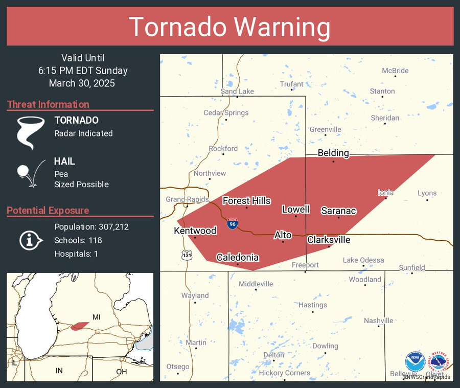
This was the Tornado Warning for Kent and Ionia Counties. Strong winds moved through eastern Kent and into Ionia Counties. The tornado sirens sounded,
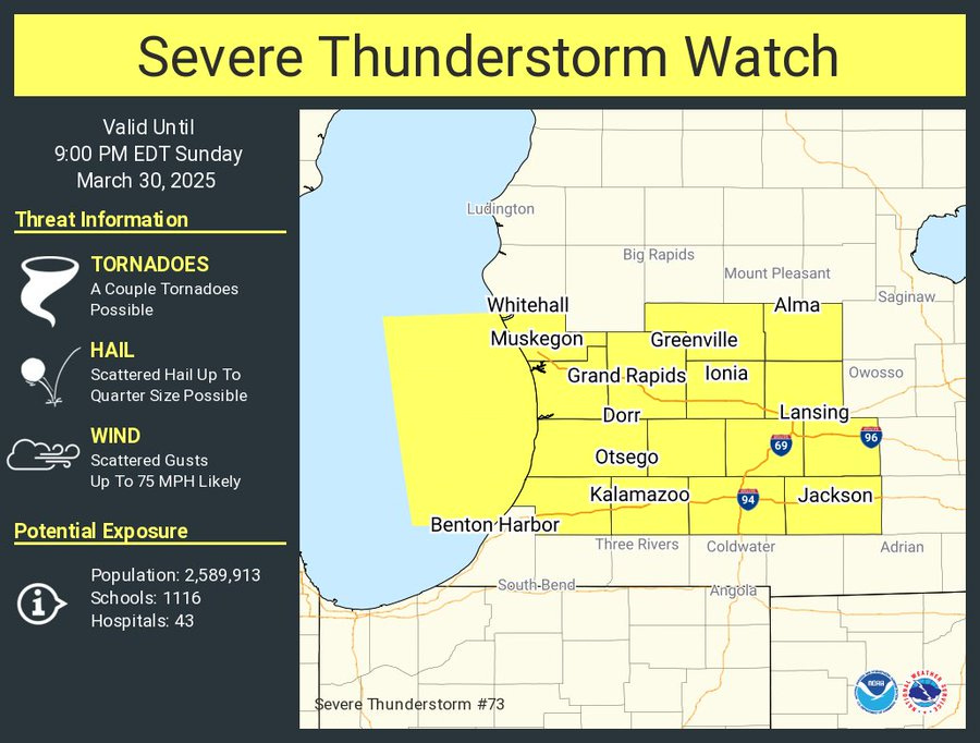
This was the Severe Thunderstorm Watch for Muskegon, Kent, Montcalm and Gratiot Counties to the south for wind gusts up to 80 mph.
Steady wind of 60 mph with a peak gust of 78 mph at the Michigan City GLERL weather station - 50 mph in downtown Chicago, 60 mph at E. Chicago, 70 mph at Kouts, IN. Wind damage reported at Orland Hills IL and Thayer IN, 59 mph at Rensslaer IN. Also a gust to 74 mph at the Gary IN Airport and at Roselawn IL - trees uprooted and signs bent along I-55. Semi blown over on US 31 at Mexico IN.
Wind Damage in northern Indiana at Wanatah, Westville (lines down across US 421), Lake Cicott, Tiosa, Dunkirk, Culver, Georgetown, Clymers and La Porte.
Wind gusts in northeast Illinois: 66 mph at Crescent City, 62 mph at Wadena and Momence, 60 mph at Beaverville, 59 mph at Boswell IN and Brook IN, 57 mph at Brook IN 3/4” hail at Algonquin, Evergreen Par, Gray’s Lake and St. John.
More severe reports: 80 mph gust at Valparaiso IN, 75 mph at Lakes of the Four Seasons in Porter Co. Indiana with shingles blown off, 74 mph at Lynwood IL, 60 mph at Munster IN and 3/4" hail at Tinley Park IL.
This was the Tornado Watch that was for northeast Illinois, northern Indiana and the Michigan counties that border Indiana. SPC said: “Tornado Watch for eastern Illinois, northern and central Indiana and the Michigan counties that border Indiana. SPC added: "potential for swaths of 60-70 mph thunderstorm gusts and a couple of tornadoes.” The line of strong to severe storms stretched southward from southeast Wisconsin to southern Illinois.
Meso-discussion from the Storm Prediction Center. They said: "SUMMARY...There is an increasing risk for severe wind gusts in central/northern Indiana and southern Lower Michigan.The Storm Prediction Center is tracking what will be a potentially significant outbreak of severe thunderstorms this Sunday afternoon and evening.
SPC INCREASED the chance of severe thunderstorms for Sunday PM in Lower Michigan. The ENHANCED (level 3) RISK area was moved north to include southern Lower Michigan - essentially south of a line from Muskegon to Saginaw.
The Enhanced Risk Area was surrounded by a level 2 Slight Risk Area (in yellow on the map above. The Marginal Risk Area (in dark green on the map above) extends north to US 10 (or up to a line from Ludington to Oscoda.
SPC then said: “Numerous severe thunderstorms are expected through tonight across a broad portion of the Southeast and lower/mid Mississippi Valley into the Ohio Valley and southern Great Lakes. Multiple swaths of widespread damaging winds appear likely. Large to very large hail and several tornadoes will also occur with supercells. A few of these tornadoes could be strong.”
I hope you will consider patronizing our sponsors, Complete Care Concierge and Ace Hardware Handyman.
This map from the Storm Prediction Center shows the % chance of a tornado within 25 miles of a given spot. The yellow area represented a 10% chance of that happening and the hatched area was a 10% or greater chance of an EF2-EF5 tornado within 25 miles of a given point.
There was a 2-5% chance of that in southern Lower Michigan.
The Grand Rapids NWS Sunday AM discussion said: “THE STORM PREDICTION CENTER HAS INCREASED THE SEVERE STORM RISK ACROSS THE AREA TODAY AS THE SLIGHT RISK (LEVEL 2 OUT OF 5) WAS MOVED NORTHWARD AS WAS THE ENHANCED RISK (LEVEL 3 OUT OF 5). THE THREAT IN THOSE TWO RANGES NOW COVERS MOST OF THE SOUTHWEST QUARTER OF LOWER MICHIGAN, WITH THE HIGHEST RISK BEING IN THE SOUTH ALONG AND NEAR I-94. WE EXPECT A BROKEN LINE OF STORMS TO SWEEP NORTHEAST THROUGH THE AREA, LIKELY DURING THE 300PM TO 900PM TIME FRAME. THE MAIN THREAT GIVEN SEASONABLY STRONG WINDS THROUGH THE DEPTH OF THE PROFILE WILL BE DAMAGING WINDS. HAIL WITH THE STRONGEST CORES HAS THE POTENTIAL TO REACH SEVERE LEVELS AS WELL, IN EXCESS OF 1 INCH. ISOLATED TORNADOES WILL BE POSSIBLE TOO...”
Above was the SPC Damaging Wind Outlook Map. It showed a relatively high 45% chance of a severe wind report within 25 miles of a given point from south of a line from Benton Harbor to Port Huron.
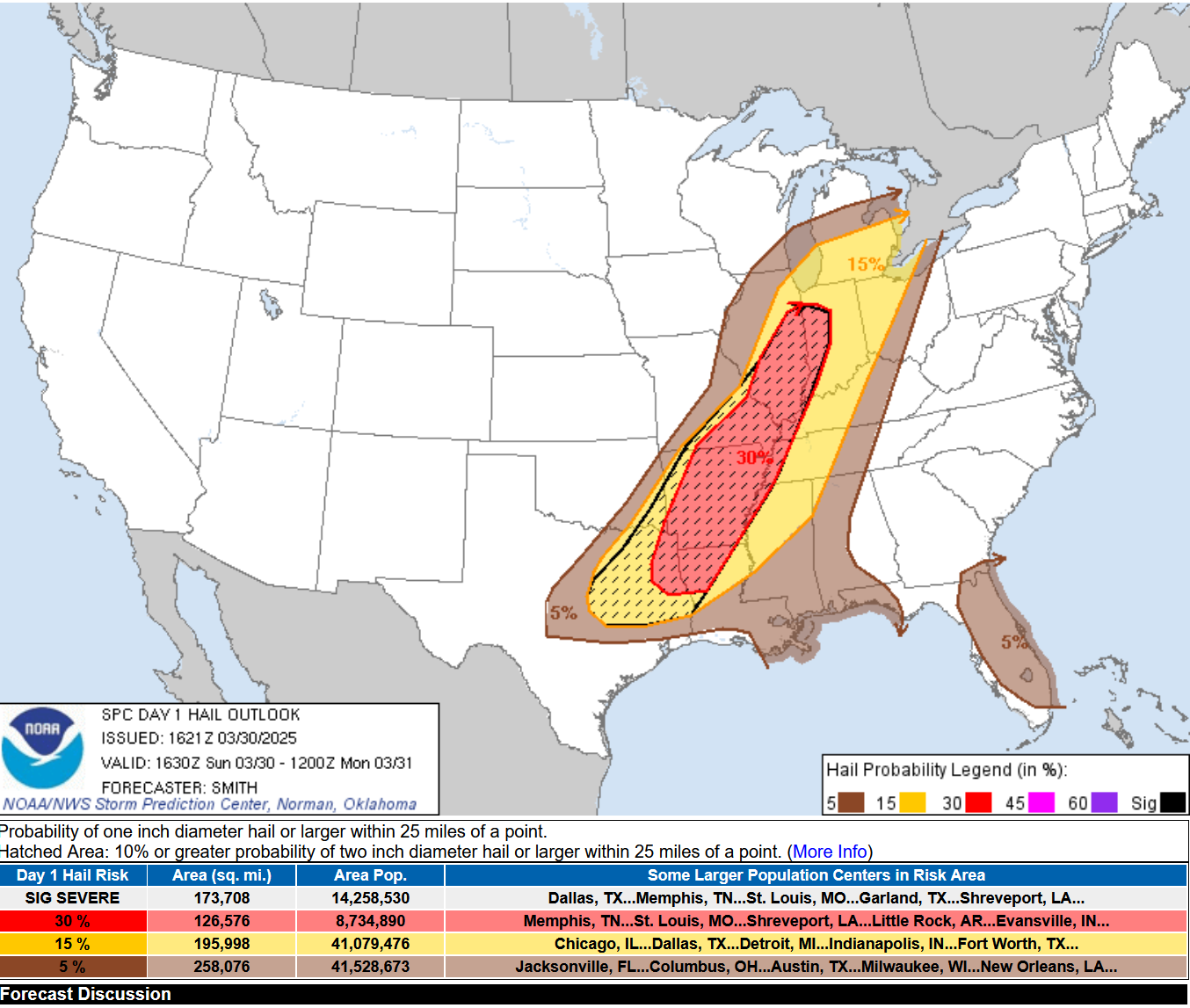
The Severe Hail Forecast (hail 1” in diameter or greater) showed the highest probability from western Indiana to northern Louisiana. Again, in southern Lower Michigan, there is a 15% chance of a severe hail report within 25 miles of a given point.
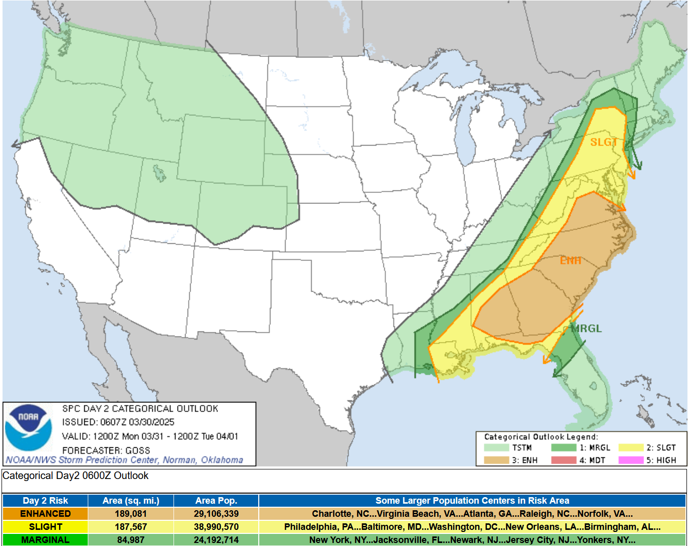
The map above is the Severe Weather Outlook Map from the Storm Prediction Center for Monday. Again, a large area is forecast to see severe weather, with an Enhanced (level 3) severe risk in orange on the map from north Florida to Washington DC and a Slight Risk (level 2) up to New York state.
Radar early Sunday afternoon
Useful links: Current Severe Thunderstorm and Tornado Watches, current Meso-discussions from SPC (often issued before a watch is issued), current Michigan weather observations, the latest Grand Rapids NWS weather discussion, a Michigan weather map (see if you can find the front).
A Tornado Watch was been issued for IL and IN.
At 4 am, the temperature at Ionia MI was 37° and the temperature at Charlotte MI was 57°. They are 31.6 miles apart. Ionia had an east wind, Charlotte a south wind.
At noon - the temperature in Grand Rapids was 61 with a south wind at 10 mph. At Big Rapids, the temperature was 39 with an east wind at 5 mph. Pretty strong front near Newaygo - that will drift slowly northward this PM. On the warm side of the front (south side) the dewpoints are in the low 60s.


Bill, Quick question, why is the national weather service coming over channel 8's signal while they are reporting on the tornadoes going on? Just curious. Thanks for all you and Michelle do.