
Severe Storms and Hot Temperatures
We'll have several chances for strong to severe thunderstorms and the heat is on, with 90-degree temperatures on the way for the weekend.

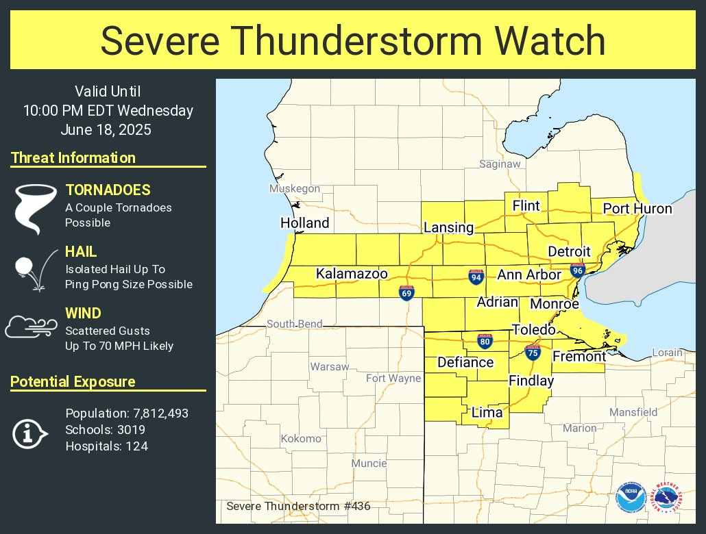
Above is the Severe Thunderstorm Watch until 10 pm. This new Severe Thunderstorm Watch is until 10 pm for southern Michigan and northwest Ohio. It includes Kalamazoo, Battle Creek and Lansing. It does not include Grand Rapids or Muskegon.
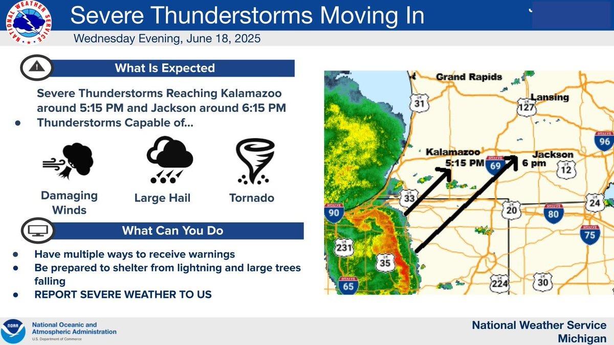
Storms moving quickly to the northeast. Heaviest storms south of a line from Benton Harbor to St. Johns.
From the Storm Prediction Center:
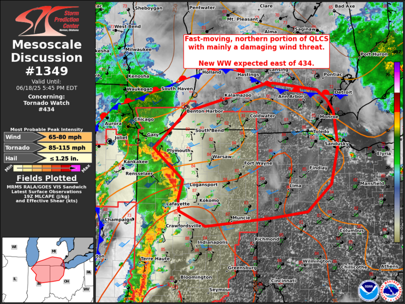
SUMMARY...Northern, fast-moving portion of line of storms should progress across the rest of northern Indiana into southern Lower Michigan and northwest Ohio through early evening. Damaging winds should be the main threat, but a tornado or two will be possible.
West Michigan and the Great Lakes area will have several chances for strong to severe thunderstorms, starting this late Wed. PM (18th) and a “heat dome” builds over the Great Lakes and Northeast into the weekend.
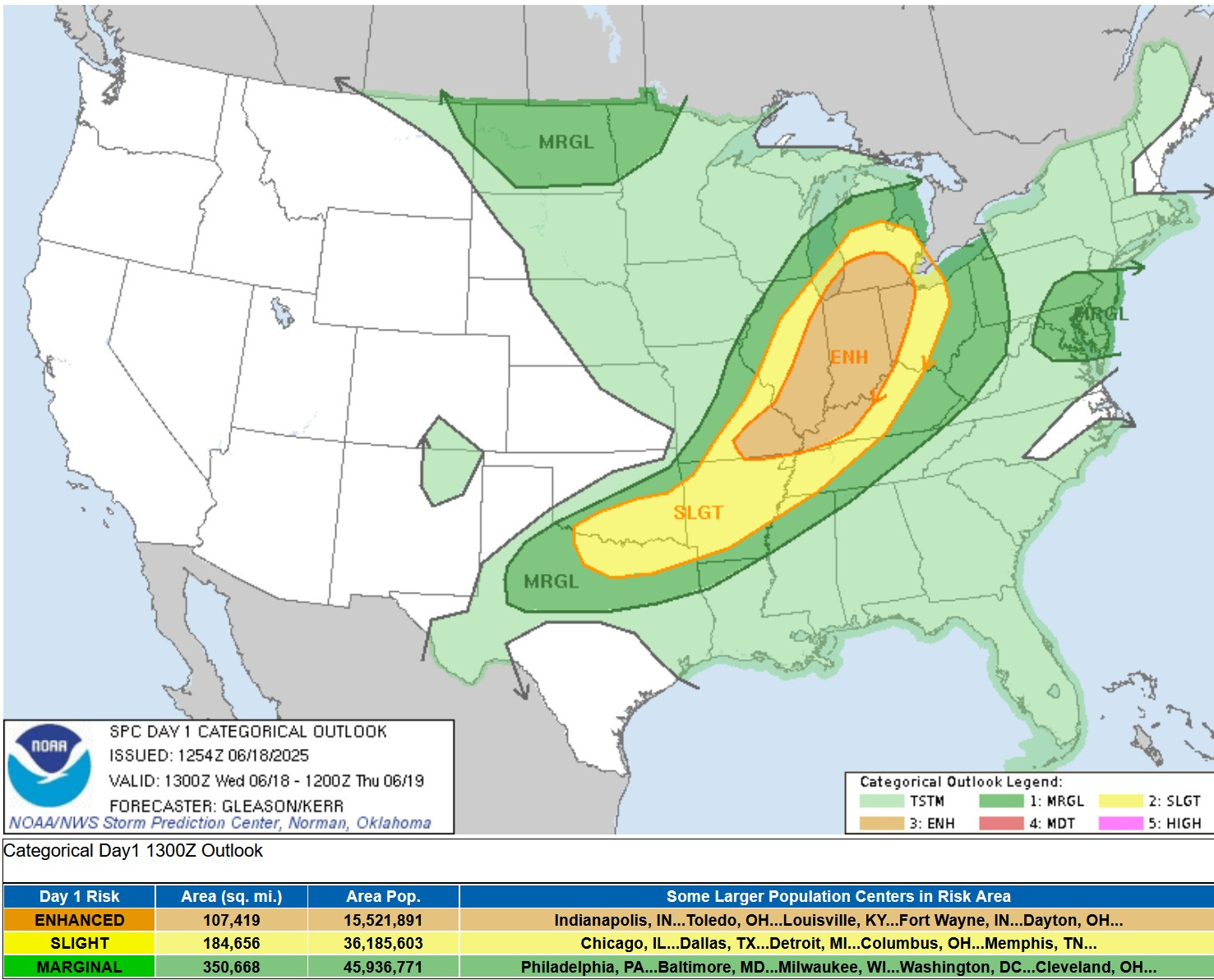
Here’s the Severe Weather Outlook Map from the Storm Prediction Center for this Wed. PM/night (the 18th). There is a level 3 Enhanced Outlook Area from north Texas northeast to southern Lower Michigan. That includes areas south of a line from Holland to Lansing to Toledo. That’s surrounded by a level 2 Slight Risk Area that comes north to a line from Pentwater to Saginaw Bay. The Marginal Risk (level 1) covers most of the rest of Lower Michigan (up to Gaylord)
SPC says: “Strong to severe storms are expected on Wednesday PM from parts of southern Missouri northeastward into southern Lower Michigan. Damaging winds, isolated hail, and a tornadoes will be possible.
As of 3:45 pm there have been 14 tornadoes - 10 of them in Illinois, 3 in Missouri and one near Fraser, Michigan. Storms in Illinois have produced winds over 70 mph.

The Grand Rapids National Weather Service says: “PARAMETERS SHOW SURFACE DEW POINTS NEAR 70°, MUCAPE (Most Unstable Convective Available Potential Energy) VALUES IN EXCESS OF 2000 J/KG AND DEEP LAYER SHEAR ON THE ORDER OF 40 KNOTS. ALL WHICH ARE VERY MUCH LINED UP FOR A SEVERE EPISODE”.
Now lets look at the individual threat levels for tornadoes, damaging wind and large hail:

This map shows the percent chance of a tornado within 25 miles of a given point. That’s at 5% for much of southern Lower Michigan, northwest Ohio, much of Indiana and Illinois.
SPC says: “some tornado threat will also exist as forecast soundings show strong low-level curvature and significant streamwise vorticity in the lowest 1km of the atmosphere. There is some uncertainty with storm mode, but a tornado threat would exist...across northern Indiana into southern Michigan and northwest Ohio.
A quick “thank you” to our sponsors, Complete Care Conceirge and Ace Handyman Services. We hope you will consider patronizing our sponsors. This covers things like paying for a graphics package the the music we use to open and close our video segments.
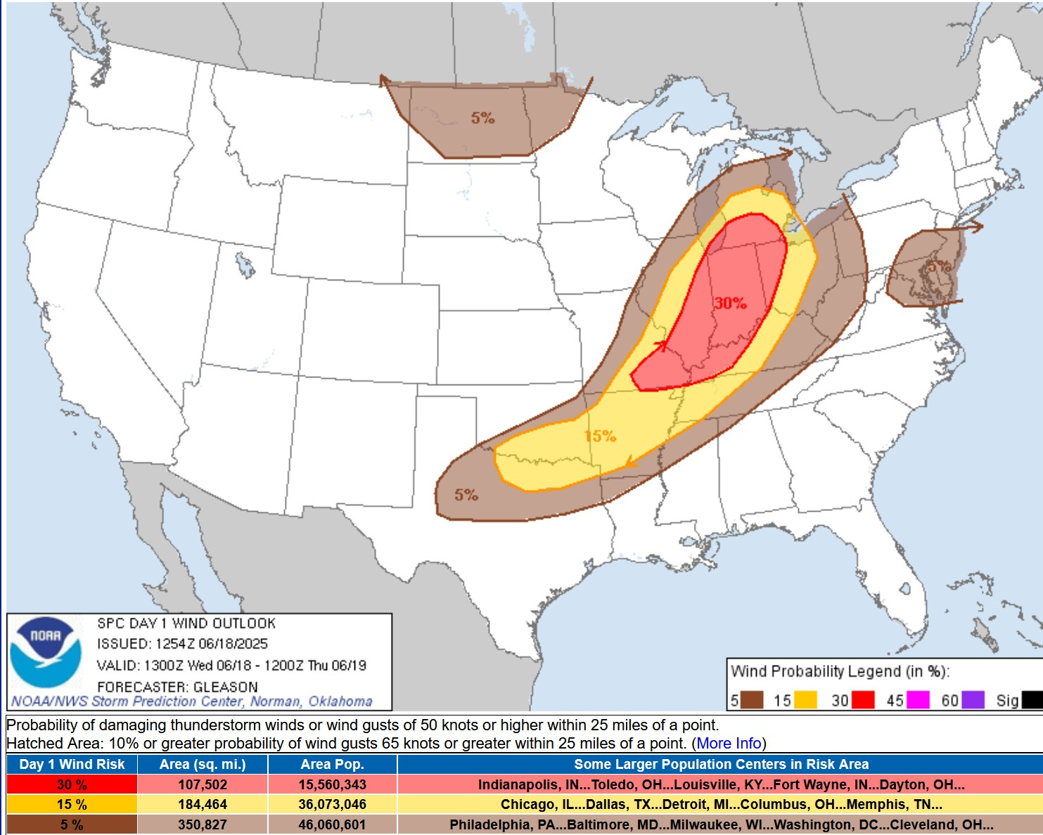
Here’s the Severe Wind Outlook from the Storm Prediction Center. In the red area above, there is a significant 30% chance of a severe wind damage report within 25 miles of a given point south of a line from Holland to Lansing to Toledo.
The tornado risk is at 5%, the severe wind risk is at 30%. So, you are 6 times more likely to have wind damage than a tornado. SPC comes right out and says: “…damaging wind gusts will likely be the primary threat.”
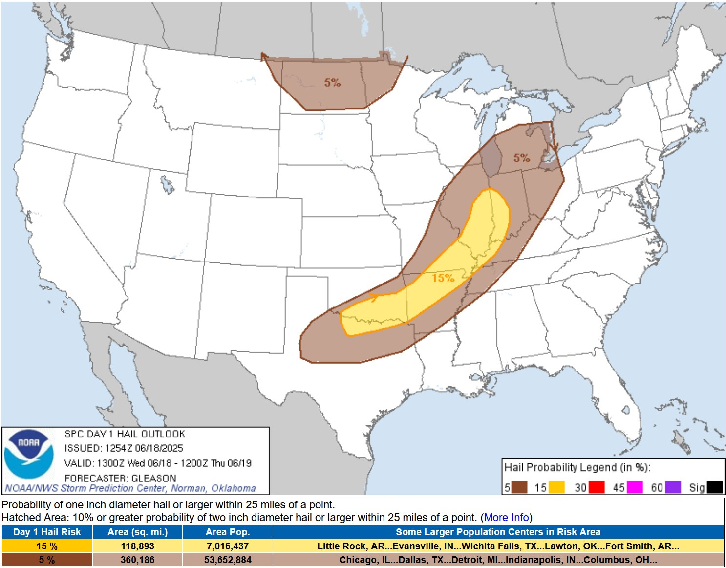
This map is the severe hail (1” in diameter or greater) outlook for Wed. PM/night. There’s a 15% risk of a severe hail report within 15 miles of a given point from the Red River Valley of OK/TX northeast to western Indiana. It’s a 5% risk for Lower Michigan.. SPC says: “Very weak (~5.5 C/km) mid-level lapse rates amid a moist profile, should mostly limit hail production.”
Useful Links: The latest Severe Weather Outlook Maps from the Storm Prediction Center, current Tornado and Severe Thunderstorm Watches, current Meso-discussions, current weather observations in Michigan, Wisconsin, Illinois and Indiana, a Michigan weather map, a Wisconsin weather map, and the latest Grand Rapids National Weather Service discussion, WOOD TV8 radar, WOOD TV8 homepage (possible live coverage Wed. evening) and the latest from meteorologist Bill Marino.
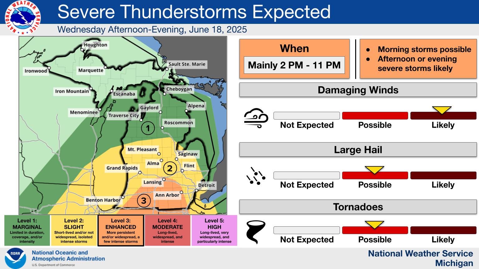
Here’s a graphic on the Wed. storms from the Grand Rapids National Weather Service. Note that they have “Damaging Winds” in the likely category. That doesn’t mean your definitely going to get damage where you are, but that there is a high chance that some areas will get thunderstorm wind damage.
The Northern Indiana NWS says: “All hazards, particularly wind damage are on the table in this environment with any organized segments or supercells.”


Radar at 4:45 am
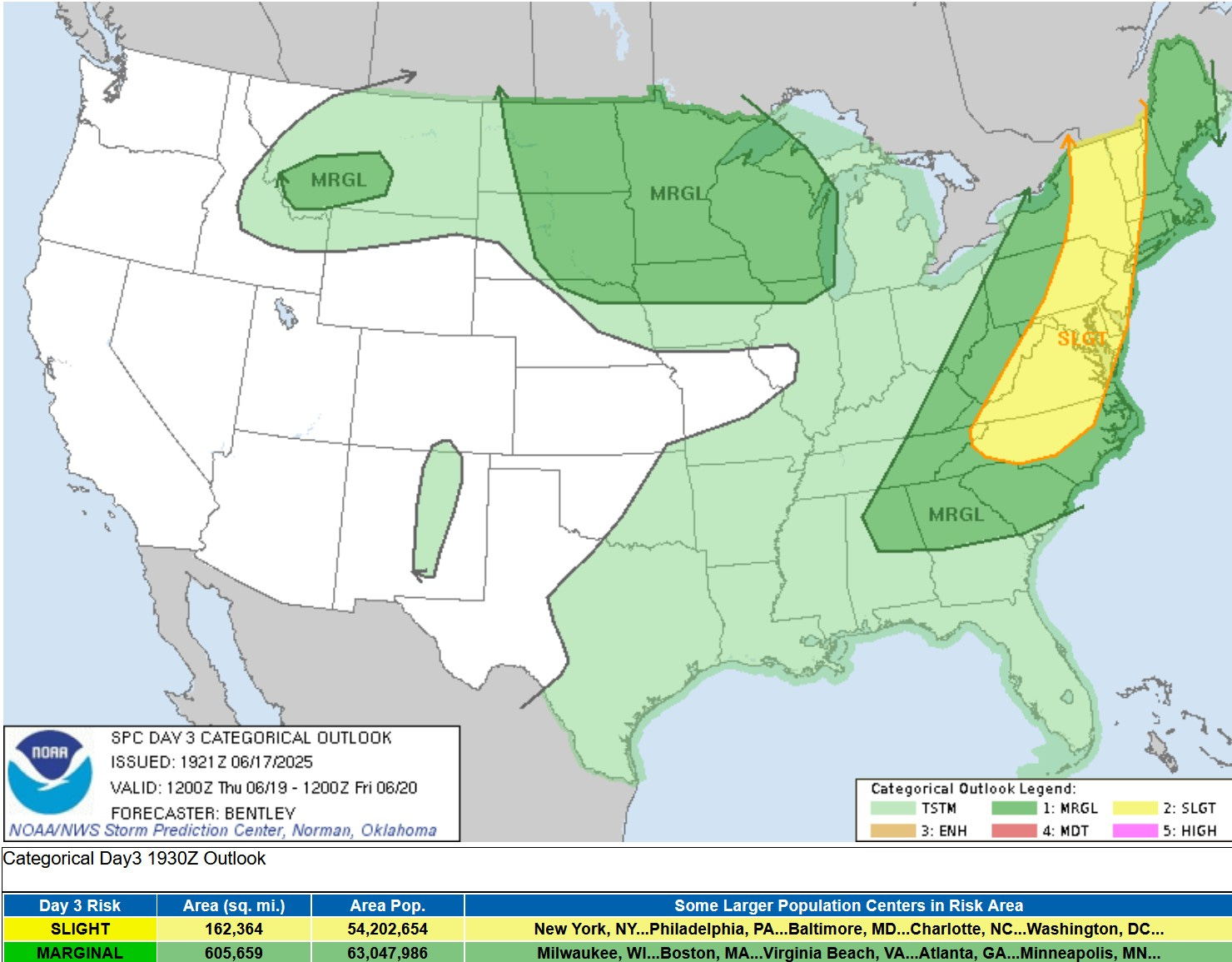
Here’s the SPC Severe Weather Outlook map for Thursday/Thursday night. The main severe weather area shifts east to the mid-Atlantic and Northeast U.S. However, there is a large level 1 Marginal Risk area that covers most of the Dakotas, all of Minnesota and Wisconsin, northern Iowa, western Upper Michigan and northern Illinois.
SPC says: “A southeastward moving mid-level shortwave trough will traverse northern Minnesota and Wisconsin Thursday afternoon. Moderate instability within this zone may permit isolated strong to severe storms where isentropic ascent is maximized. Large hail and damaging wind gusts would be the primary threat.”

Beyond Thursday, there are chances for severe storms. SPC says: “the pattern suggests potential for a thunderstorm complex to develop and move eastward Friday night across the upper Great Lakes vicinity.” SPC has a Slight Risk (level 2) from North Dakota to northern Lake Michigan, with a Marginal Risk down to Muskegon and Mt. Pleasant. The main threat would b strong winds across northern Wisconsin, Upper Michigan and northern Lower Michigan.
For Saturday/Saturday night SPC says: “There may also be some potential for strong to severe storms along the northeast periphery of the ridge into parts of the lower Great Lakes and New England.
Then for Sunday - Tuesday (22nd - 24th), SPC says: “Strong to severe storms and possible MCS development could continue to occur along the periphery of the ridge.”
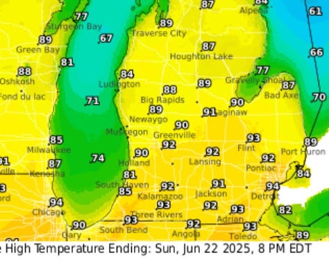
The other big story is the heat dome that develops over the Great Lakes and northeast. Here’s forecast high temperatures for Sunday. Grand Rapids and Kalamazoo reach 92, Chicago and Detroit have forecast highs of 94. It will be relatively humid, so the heat index may reach the upper 90s to near 100 in some places here in the Great Lakes.
The severe weather parameters will be adjusted by the Storm Prediction Center around 2 am and I’ll stay up to update this thread. Thanks for reading my post to the end. Remember, I’m on facebook and X. My YouTube channel is billsteffen 616. I do daily videos with my daughter highlightning weather and interesting facts about Michigan and the U.S. My little corner of the internet is www.billsteffen.com. Hope you’ll check it out.
ALSO: Tornado video from Nebraska on Monday. The latest on gasoline prices from our GasBuddy, Patrick DeHaan. Volcano erupting in Indonesia. Incredible lightning above volcano in Guatamala. Amazing hailstorm in Brazil. Huge hail and flooding in China. Hurricane Erick will slam into southwest Mexico. Two volcanoes in the same view. 77 minutes of a tornado squeezed down into one minute. Tornado and a rainbow in the same shot. Near-record flooding in China. Honda imitates Elon Musk. Extreme flooding in India. Flooding in West Virginia. Mexico meteor. Large hail in Italy. Big wildfire in Greece. Flash flood in Russia. Flash flood in Mexico. Flooding in West Africa. Magnitude 5.6 earthquake in Peru. Lenticular clouds in Guatamala. Volcanic eruption covers the moon.
Thank you so much for the updates