
Severe Storms Hit IN, OH Tuesday PM
Severe Storms Possible Again Thursday PM and Saturday

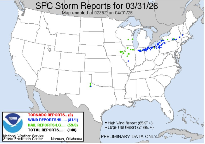
Plotted on the map above are severe weather reports from Tuesday PM/night. Reports are still coming in, so this is not a complete list. There is a blue dot plotted for each wind damage report and a green dot for a report of hail 1” in diameter or greater.
A couple things to note here. First - no tornadoes reported so far. The Storm Prediction Center issued timely Severe Thunderstorm Watches (not Tornado Watches) from Illinois across Indiana and Ohio into the Northeast.
Second, no severe weather in Michigan. There was a 51 mph gust at Pontiac (severe criteria is 58 mph. In West Michigan the general wind was stronger Monday night than it was in the thunderstorms.
Third, note the severe weather was in a narrow line west to east. There was some training of storms. Some places had more than one storm. Second, the storms needed the heat of the day to get to severe levels…to create instability.
The strongest measured wind gust was 75 mph at the Cleveland Airport (Hopkins International). The Lakefront Airport in Cleveland had a gust to 71 mph. I saw at least four places where there was building/roof damage from the storms.
The cold front passed through Kent Co around 4 pm Tuesday. The Ford Airport was still barely in the warm air at 4 pm and despite some rain, the temperature there was 64°at. By 5pm, the airport dropped to 53°, a drop of 11 degrees in an hour. Where I live in Comstock Park, the temperature at 4 pm was 50°. So, that was a 14-degree temperature difference just across the city of Grand Rapids. Ludington was down to 37°. At 5 pm, Marquette was 28 degrees, thick fog and a north wind at 17 mph wind coming off chilly Lake Superior. They had a wind chill factor of 16°. Certainly cooler temperatures for us on Wednesday.
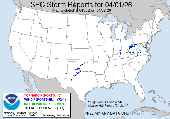
This map shows severe reports for Wed. 4/1 as of 1:05 am. Hail to the size of tennis balls and wind gusts to 75 mph were reported with the storms in OK/TX
You should check out the Grand Rapids National Weather Service forecast discussion. They cover everything from the chance of severe weather to the chance of freezing rain to the outside chance of a little snow (and wind) on Easter Sunday. Here’s the link.
They say: “Active Pattern Continues into the weekend - with additional chances for severe weather on Thursday and Saturday. Some severe weather possibilities exist for both days with Saturday starting to look like a potentially greater risk than late Thursday.”
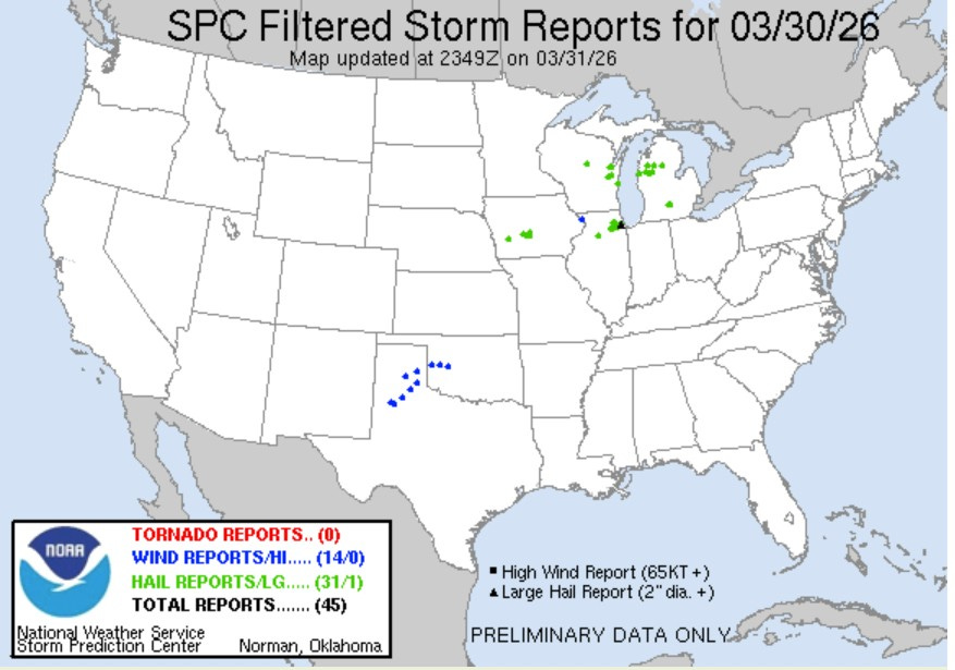
Here’s severe storm reports from Monday/Monday night. We had some hail reports in Lower Michigan.
Hail 1.25” in diameter fell at Freesoil MI Monday night, with 1” diameter hail at Eaton Rapids, Lake City, Tustin, Irons, Onondaga and Luther. 2” diameter hail (the size of an egg) fell at Berwyn IL, a suburb of Chicago.
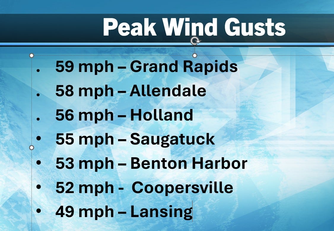
The wind was howling Monday night (early Tue. AM). Here are some peak wind gusts. Over 3,000 customers lost power. This was not wind generated by a thunderstorm.
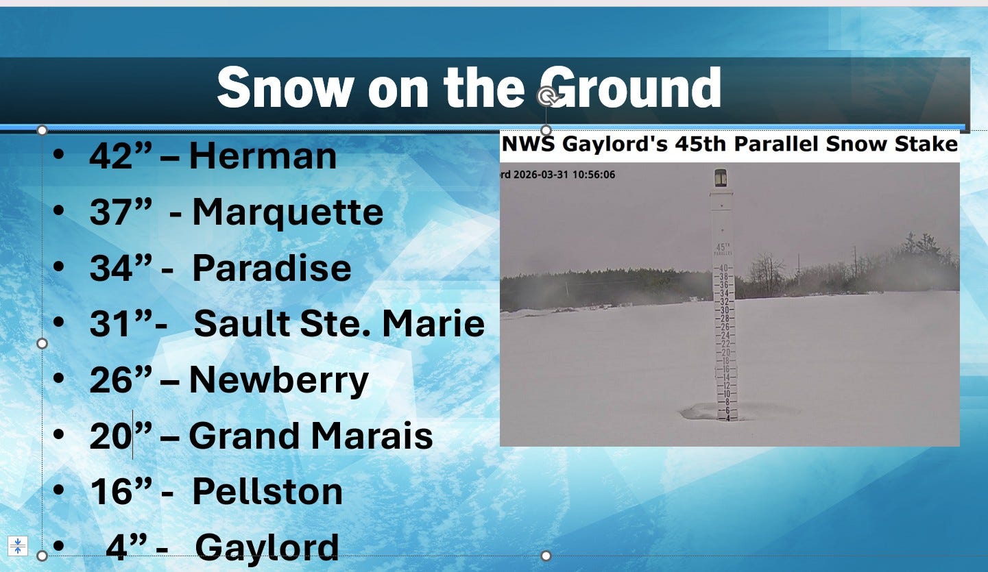
Here’s snow on the ground Tuesday morning. While southern Michigan does not have snow on the ground (Grand Rapids had just 0.7” of snow this March), there has been a lot of snow in northern Michigan. The town of Herman, west of Marquette, has had 77.5” of snow in March. Herman is up to 354.5” for the winter season. The record season snowfall for Michigan is 390.4” near Mohawk in the Keweenaw Peninsula back in 1978-79.
BTW, we ended up with 12 days in March that reached at least 60 degrees in Grand Rapids - following a colder than average winter (from Nov. - early Feb.).
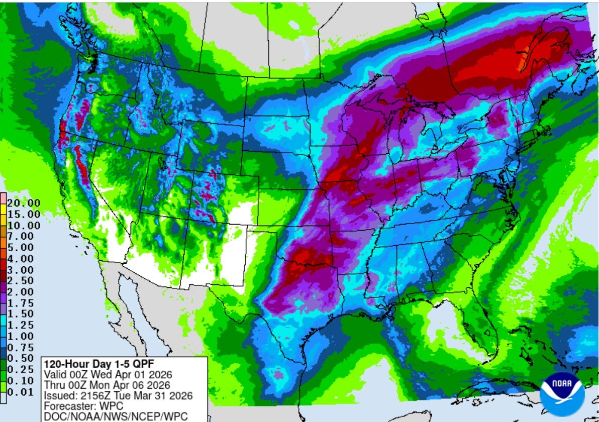
This is the Total Rainfall Outlook for the next 5 days combined, through next Sunday night. That’s a rather stormy pattern for much of the U.S. and in April that also means severe weather, especially from Texas north to the Great Lakes. There will also be a chance of a little local flooding in heavier rain area.
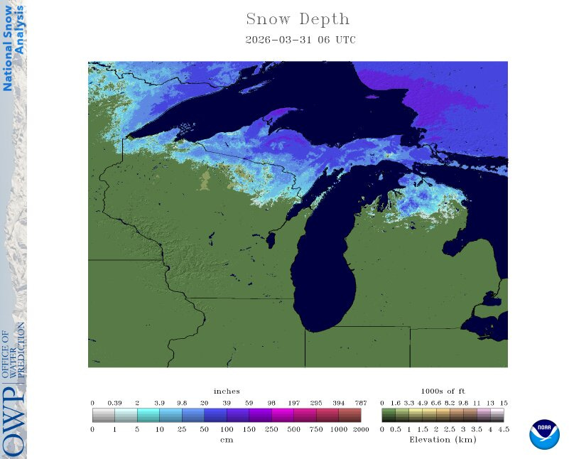
Here’s snow cover in N. Lower MI and Upper Michigan. The Gaylord snow stick measured around 4” early Tuesday AM. Herman in Upper Michigan is up to 354.5” for the winter season. The record season snowfall for Michigan is 390.4” near Mohawk in the Keweenaw Peninsula back in 1978-79.

My daughter #1 snapped this pic. of few days ago. It looks like a smiling rainbow. It’s actually a circumzenithal arc. When you see a rainbow, the sun is at your back. When you see a circumzenithal arc, you’re generally looking toward the sun…the sun would be below the arc. An arc like this only occurs when the elevation of the sun is less than 32°.
Finally, a cat update. I have 3 cats and Sunday evening, I watched as “Joy” discovered a stinkbug walking across my living room rug. The bug stood out nicely and was making steady progress after probably coming down the fireplace. Joy sneaked up very slowly and seemed to think the bug didn’t notice her, even though she’s 1,000 times bigger than the bug.
Joy stared down the bug for a good five minutes without moving, then she started pawing in very gently. Now, my old cat Nimbus would have pounced on the critter and devoured it in 3 seconds. I remember watched Nimbus eat a ladybug and even a lethargic fly. She considered the the few mice she cornered in the basement playthings for the chase, so she didn’t eat them.
After a little while, I picked up the stinkbug and set it outside on the picnic table for the birds to find. Joy looked so sad - I took away her newe toy. Oh well, I know there will be more stinkbugs for her to find.
Thanks, Bill. It's not morning without coffee and Bill Steffen.
How about thursdays weather. Coming north. Snowbirds flying home