
The Threat of Severe Weather Has Been Significantly Reduced for Much of West Michigan.
While not eliminated, the threat of tornadoes and damaging wind has been lowered for West Michigan.

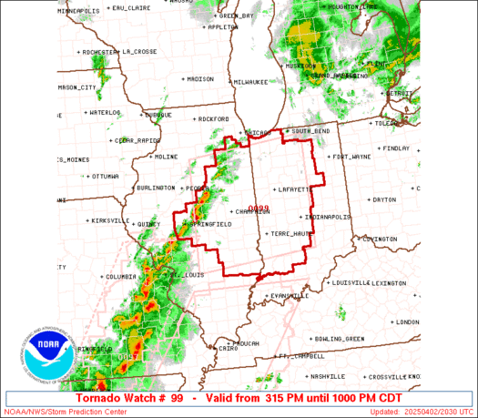
4:45 pm - A new Tornado Watch has been issued for Illinois and Indiana. Storms forming a line from Chicago to St. Louis will move east. It looks like the strongest storms will be south of a line from Gary, Indiana to Kalamazoo MI to Lake St. Clair.
For this Tornado Watch: : PROBABILITY TABLE: PROB OF 2 OR MORE TORNADOES : 80% PROB OF 1 OR MORE STRONG /EF2-EF5/ TORNADOES : 50% PROB OF 10 OR MORE SEVERE WIND EVENTS : 90% PROB OF 1 OR MORE WIND EVENTS >= 65 KNOTS : 50% PROB OF 10 OR MORE SEVERE HAIL EVENTS : 50% PROB OF 1 OR MORE HAIL EVENTS >= 2 INCHES : 20% PROB OF 6 OR MORE COMBINED SEVERE HAIL/WIND EVENTS : >95%
The Storm Prediction Center is forecasting a dangerous outbreak of severe thunderstorms and tornadoes this evening and tonight.
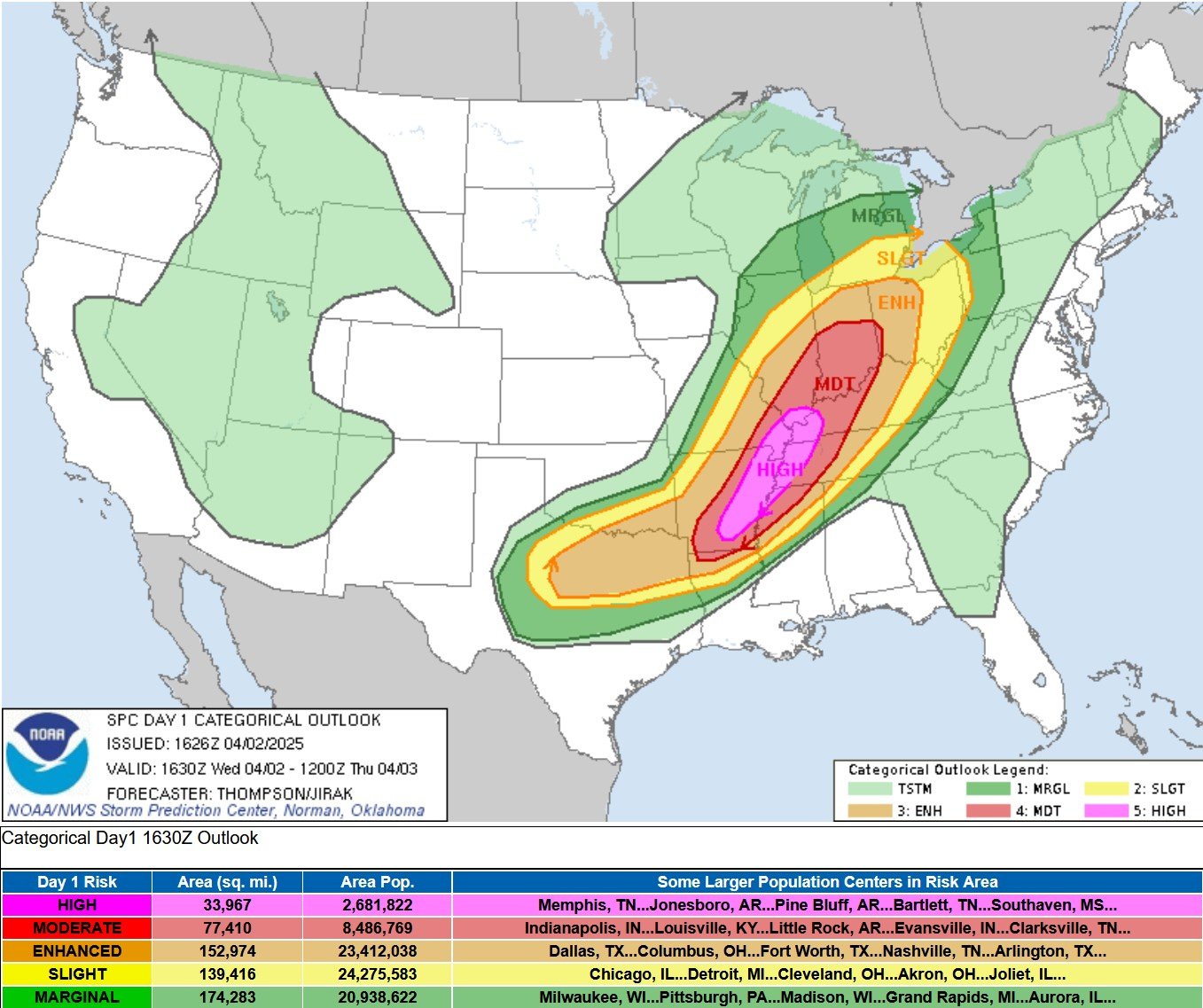
The Storm Prediction Center has significantly reduced the chance of tornadoes and thunderstorm wind damage in West Michigan north and west of Grand Rapids. The level 3 Enhanced Outlook as been eliminated in Michigan. We still have a slight risk (level 2) south of a line from Holland to Grand Rapids to Port Huron and a Marginal Risk (level 1) to the north of that line.
SPC says: “The northern extent of the surface warm sector (northeast IL across northern IN/northwest OH/southern Lower MI) will be modulated by ongoing convection.”

Here’s the % chance of a tornado within 25 miles of a given point. A 30% chance of a tornado within 25 miles of a given point (pink area on the map above) is a very rare forecast. The green color over Southern and Central Michigan is a +2% chance of a tornado within 25 miles of a given point. While a smaller risk is still there, you can see the most likely area to see strong tornadoes is south of Michigan.
I hope you will consider patronizing our sponsors, Complete Care Concierge and Ace Hardware Handym
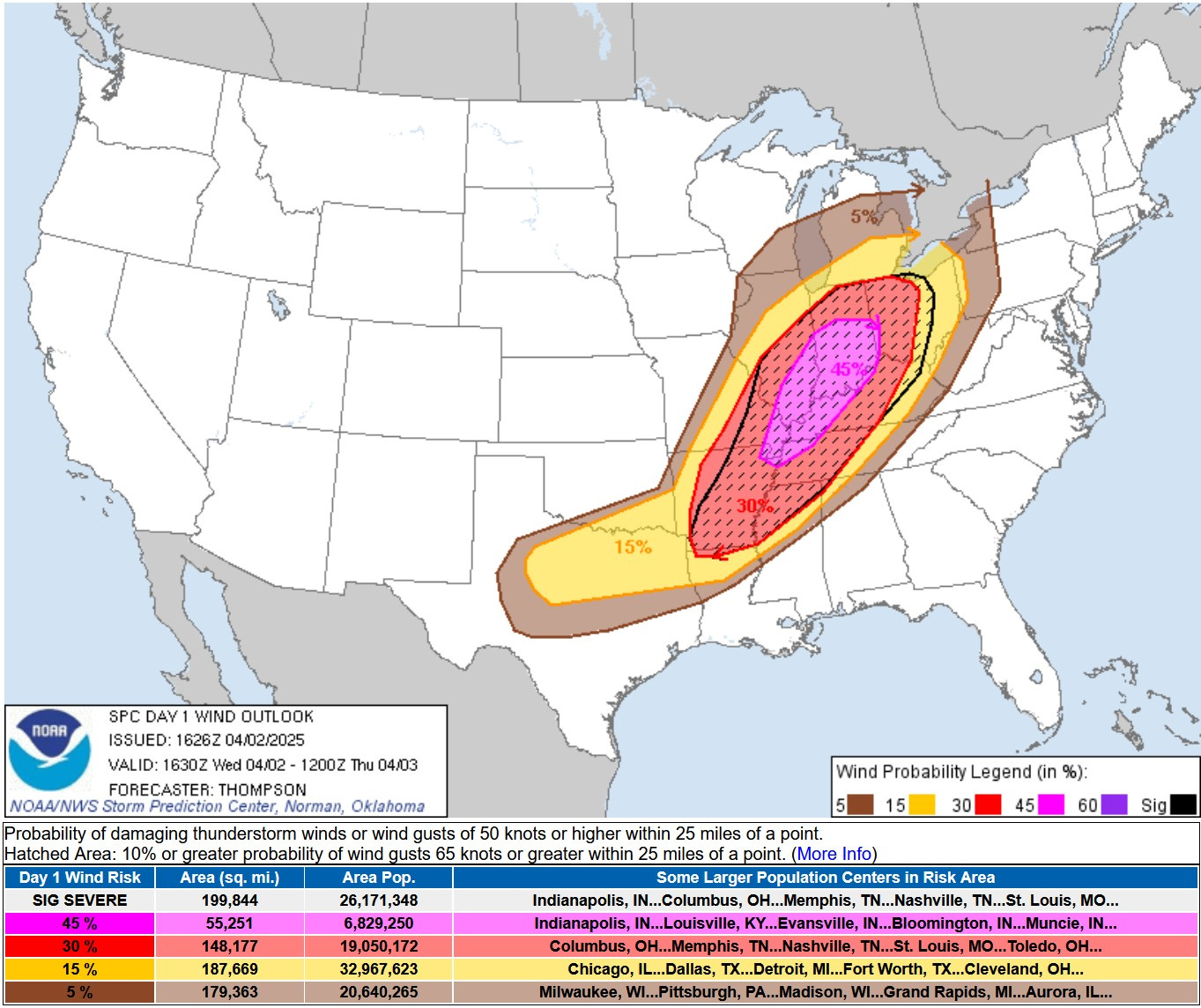
This is the Severe Wind Forecast from SPC. The pink area is at least a 45% chance of a severe report within 25 miles of a given point. The hatched area is a 10% or greater chance of wind gusts of 75 mph or higher within 25 miles of a given point.
You can see that the 15% risk still covers areas south of a line from South Haven to Grand Rapids to Port Huron with a 5% risk to the north of that line. However the main wind threat will be in the warmer air down in Indiana and Ohio.
Indianapolis had a gust to 60 mph shortly before 3 pm. That was not a thunderstorm gust, just the strong south-southwest wind on the south side of the warm front.
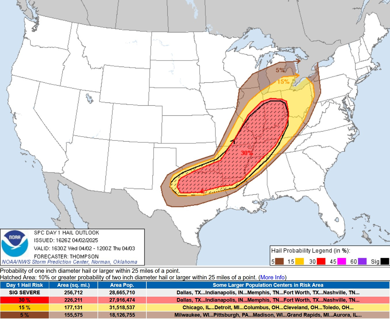
This is the % chance of a severe hail report within 25 miles of a given point. We’re at 15% south of a line from South Haven to Port Huron and 5% to the north of that line. The higher chance is in the red-hatched area down in Indiana and Illinois south to northwest Louisiana.
Bottom line - while severe hail (1” in diameter or bigger) will likely be south of Michigan, I can’t rule out some small hail in one or two of the thundershowers here in West Michigan.

Here’s a graphic on the Wednesday evening storm potential from the Grand Rapids National Weather Service. Check out their latest forecast discussion, which goes into the factors that will determine the extent of any severe weather in MI.
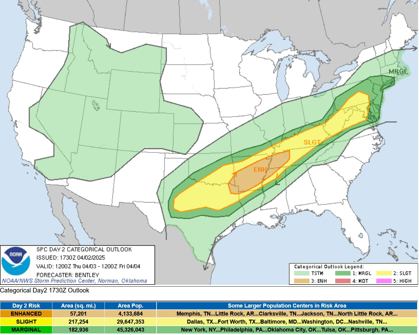
This is the Severe Weather Outlook Map for Thursday. No levels 4 or 5 risk areas as the as I type this Wed. PM, but there is an Enhanced Risk Area from northeast Texas to western Tennessee and a large Slight Risk (level 2) from Texas to Pennsylvania. Storms should stay south of Michigan on Thursday.
With multiple days of heavy rain, flooding will be an increasing and significant problem from Arkansas northeast to Ohio.
There are Gale Warnings for Lake Michigan until 11 pm for 4-10 foot waves and gust to 40-50 mph.
Here’s current weather observations in Michigan and a Michigan weather map.
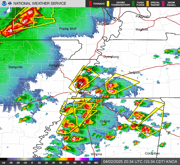
Memphis Radar loop ending 5 pm Wed. showing the warnings (yellow polygons).