
Heavy Snow, Strong Wind, Blowing and Drifting Snow, Tough Travel
and St. Patrick's Day is going to be significantly colder than last Christmas

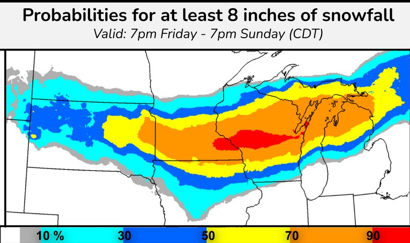
Two quick storms will bring heavy snow, blowing and drifting snow, very strong wind and treacherous travel to the Midwest and Great Lakes. The above graphic shows the probability of over 8” of snow. The red area is a 90% chance - a virtual certainty - for parts of southeast Minnesota and central Wisconsin. The is a large 70% likelihood from eastern South Dakota to northern Lower Michigan, including Traverse City, Cadillac Gaylord and Mackinac Island.
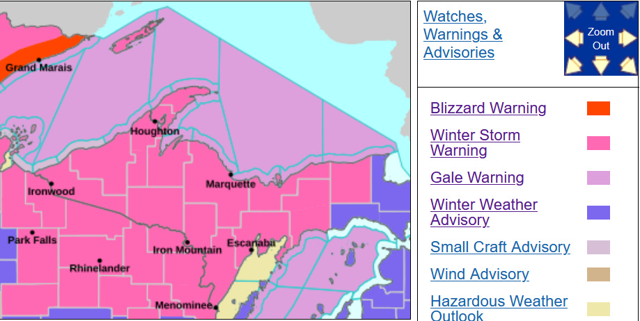
The counties in pink have a Winter Storm Warning. The counties in purple have a Winter Weather Advisory. The National Weather Service at LaCrosse WI writes: “Highest total snow accumulations between 12 and 18 inches with localized amounts
approaching 24 inches possible.
The Gaylord MI NWS says this about the snow today (first part of the storm): “Expect snow amounts to vary from 2-5” along and south of M-55…with amounts of 4 to perhaps 8” to the north.”
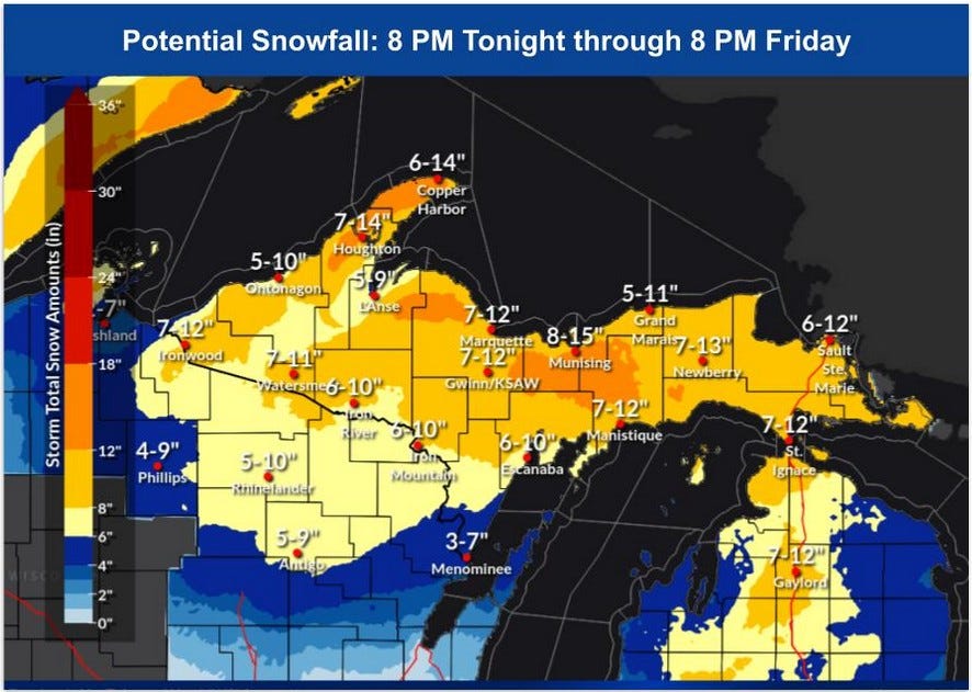
Here’s forecast snow amounts for the first storm…today and tonight. Expect the strong winds to cause some blowing and considerable drifting snow.
This storm will bring a lighter mix of precipitation to much of the rest of Lower Michigan, along with very strong wind (more on that later). There will be a bit of a lull in the storminess on Saturday before the true Arctic air arrives. It’s going to be significantly colder on St. Patrick’s Day than it was on Christmas!
Then comes the 2nd storm, which will likely be worse than the first storm. Regarding this event, the Gaylord NWS writes: “IF CURRENT TRENDS DO INDEED
HOLD, PARTS OF NORTHERN MICHIGAN COULD EASILY SEE SNOW AMOUNTS WELL IN EXCESS OF A FOOT BY LATER MONDAY, AND UNFORTUNATELY SIGNIFICANT AMOUNTS OF FREEZING RAIN AS WELL. DEPTH OF LOW (SOME PROGS SHOW SUB 80MB FINAL OUTCOMES) WOULD ALSO YIELD QUITE THE WIND EVENT.” The first wind event is today (Friday) and then the 2nd wind event would be Saturday night into Monday.
SIDE NOTE: The all-time Michigan record for season snowfall is 390.4” near the town of Mohawk in the Keweenaw Peninsula of Upper Michigan. That was during the winter of 1978-79.
So far this winter, Mt. Bohemia has has 305” of snow and Tamarack is up to 304” for the winter. Tamarack has a current snow depth of 52”. The town of Herman has had 288.5” and that’s 113.6” above average-to-date. Marquette has had 214.6” of snow this winter. Currently they have 29” on the ground and S. Ste. Marie has 24” of snow cover.
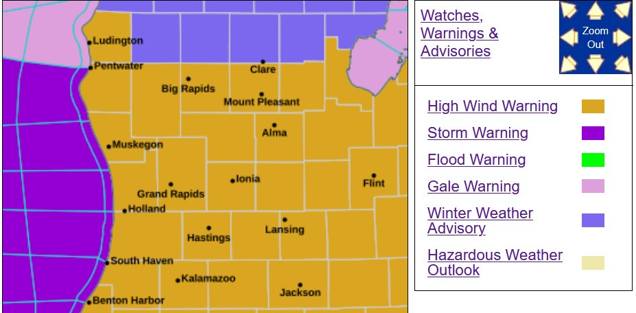
The tan counties are under a High Wind Warning today for steady winds of 25-35 mph and peak gusts of 50-60 mph. Winds this strong can bring down tree limbs and we could see isolated power outages. It’s best if you don’t park your car under a tree if possible.
Monday looks like another very windy day. The purple over Lake Michigan is a Storm Warning. That’s one step above a Gale Warning and one step below a hurricane warning.
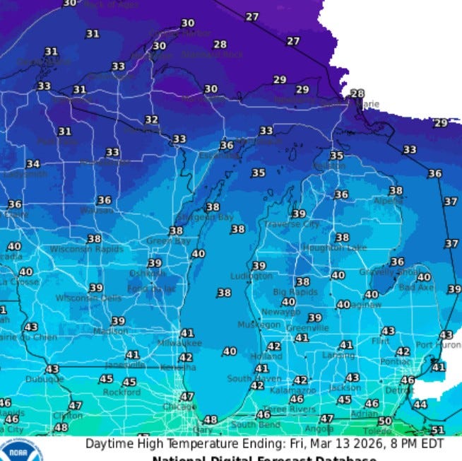
Let’s take a look at high temperatures for the next few days. Here’s today (Fri.)…low 40s (mid-upper 40s at the Indiana border). Temperatures will fall to the mid 30s by sunset and the wind will make it feel colder than these temperatures indicate.
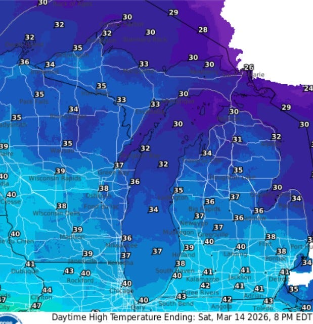
Here’s Saturday…highs near 40°, the wind won’t be nearly as strong as Friday. With fresh snow, you might want to get the skis or snowmobile out one more time. Here’s ski resort conditions. Ski resorts in the U.P. are open and northern Lower MI and the U.P. will have enough snow to run the snowmobile.
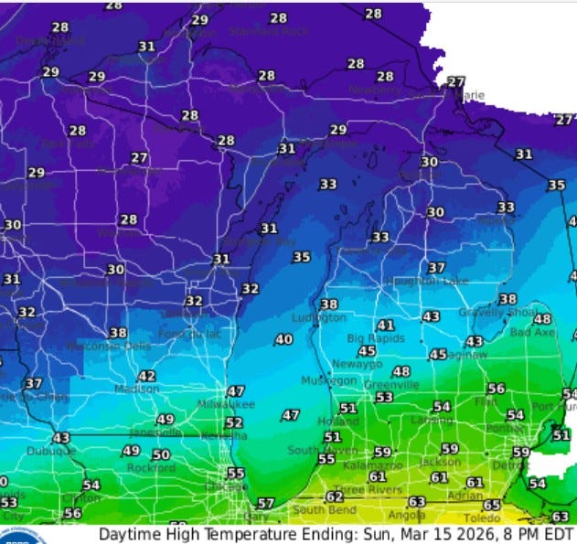
Here’s high temperatures for Sunday. The “warm air” makes a relatively brief run into southern Lower Michigan. It could reach the mid 60s at the Indiana and Ohio border and hold in the 30s at Ludington and Baldwin.
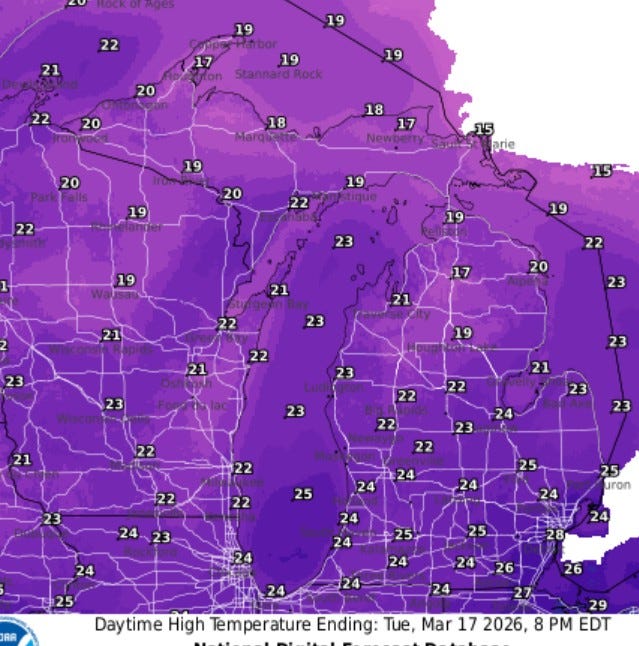
Finally, here’s the high temperatures for St. Patrick’s Day (Tue. the 17th). Shiverin’ Shillelaghs! These highs are about 20 degrees colder than average…just mid 20s with a few spots in northern Lower and Upper Michigan failing to reach 20°. BTW, the coldest high temperature ever in G.R. on St. Patrick’s Day was 10° in 1941. We won’t be that cold.
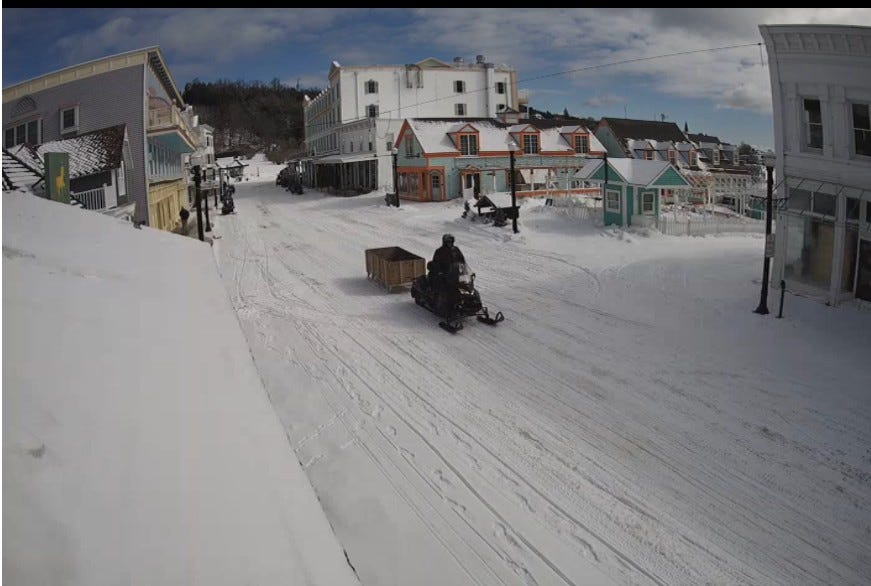
This was Main Street on Mackinac Island on Thursday. No vehicles, you get around on snowmobile, horse and buggy or just plain walking. There’s plenty of snow up here and lots more on the way over the next four days. (pic. from the Horn’s Bar webcam).
Some interesting weather in the next few days here in the Great Lakes…keep up with the latest forecasts and alerts. Have a good weekend.
Thank you
Thank you Bill!!