
Heavy Snow, High Winds and Difficult Travel
1-3 FEET of snow for parts of Upper Michigan

Two major storms will bring very heavy snow, high winds and possible blizzard conditions to Upper Michigan and parts of northern Lower Michigan. The storms will bring some snow and strong wind to southern Lower Michigan.
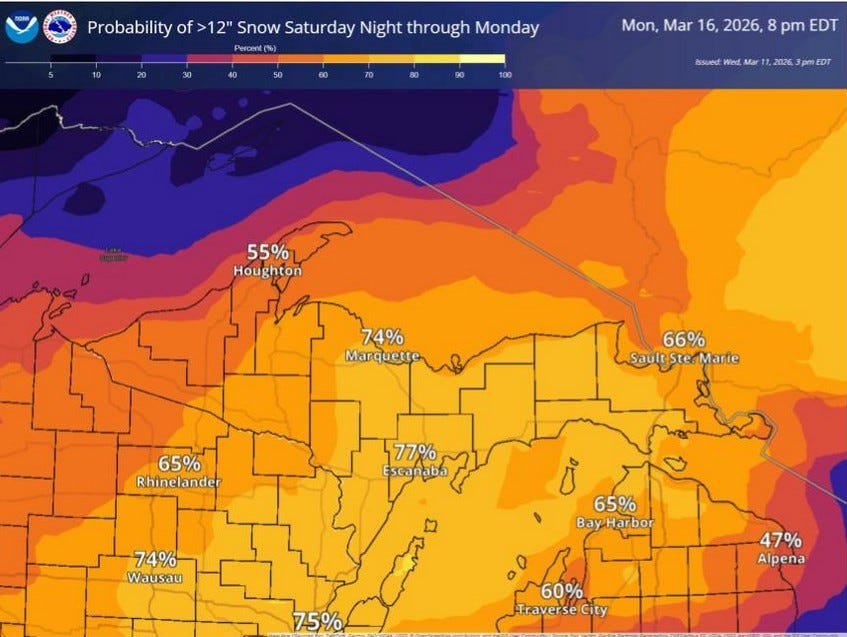
This map from the Marquette NWS shows the forecast chance of more than a foot of snow just from the Saturday night to Monday storm. Most of Upper Michigan and northern Lower Michigan has a better than 50/50 chance of seeing MORE THAN A FOOT OF SNOW just from this storm. Strong winds with the storm could gust to 40-50 mph, causing blowing and drifting snow and possible blizzard or near blizzard conditions. I anticipate some school closings up here on Monday with possible isolated power outages. Southern Lower Michigan will see strong wind and a mix of precipitation. This is for the 2nd storm…now the first storm:
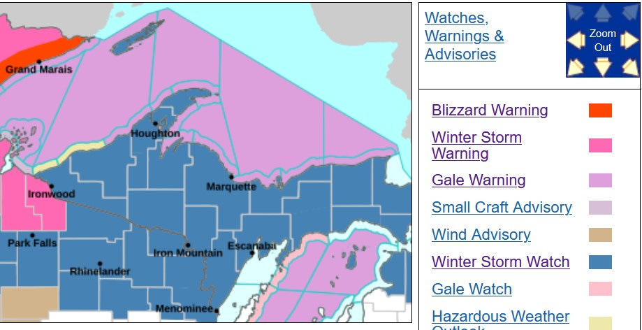
There’s a Winter Storm Watch in effect for all of Upper Michigan, plus Emmet and Cheboygan Counties of Lower Michigan for this (Thu.) evening through Friday afternoon. This first storm could produce 5-12” of snow, wind gusts to 45 mph, considerable blowing and drifting snow and treacherous travel conditions.
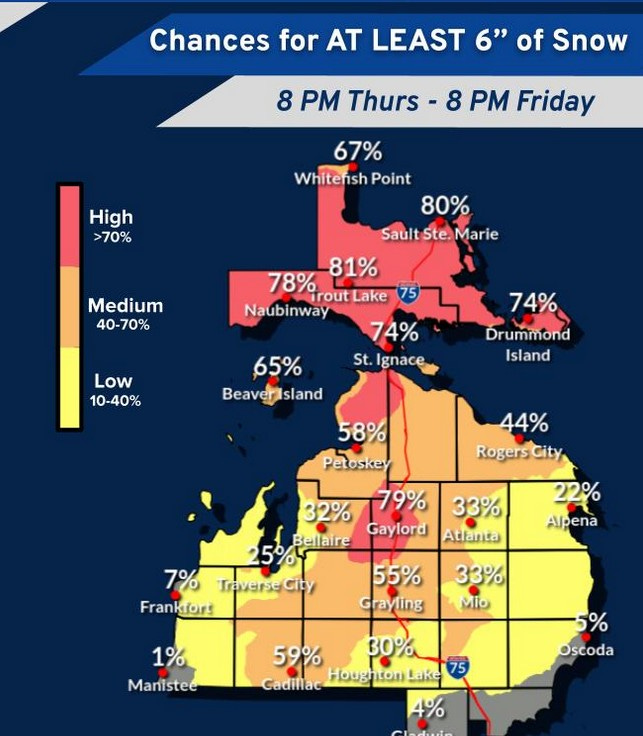
Here’s what the Friday storm could mean for N. Lower Michigan. This is the percent chance of 6” or more of snow from this storm…59% for Cadillac, 79% for Gaylord.
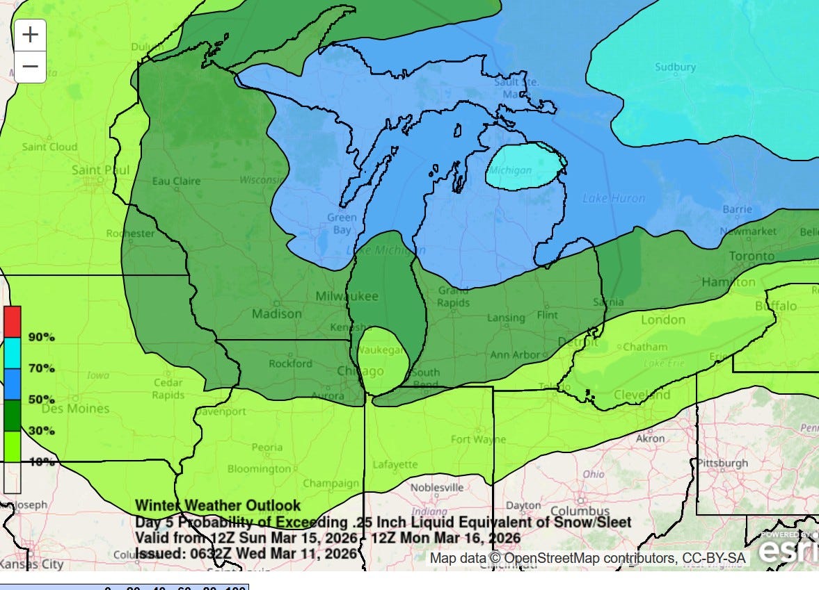
This map from WPC shows the Day 5 (Sunday/Sunday night) probability of 0.25” of precipitation…that would likely be 3-4” of snow…the 50% line comes down to around Montague to Rockford to Midland. There will be places in the U.P. that see 2 FEET of snow in the next several days.
So, there will be two big storms (low pressure centers) crossing the Great Lakes. These will be windy storms with steady winds of 20-35 mph on Friday with gusts to 50-60 mph possible (most likely area to see the strong gusts is the Lake Michigan shore). Monday will also be a windy day. As the Arctic air arrives, temperatures may only be in the mid-upper 20s on Monday and Tuesday (St. Patrick’s Day).
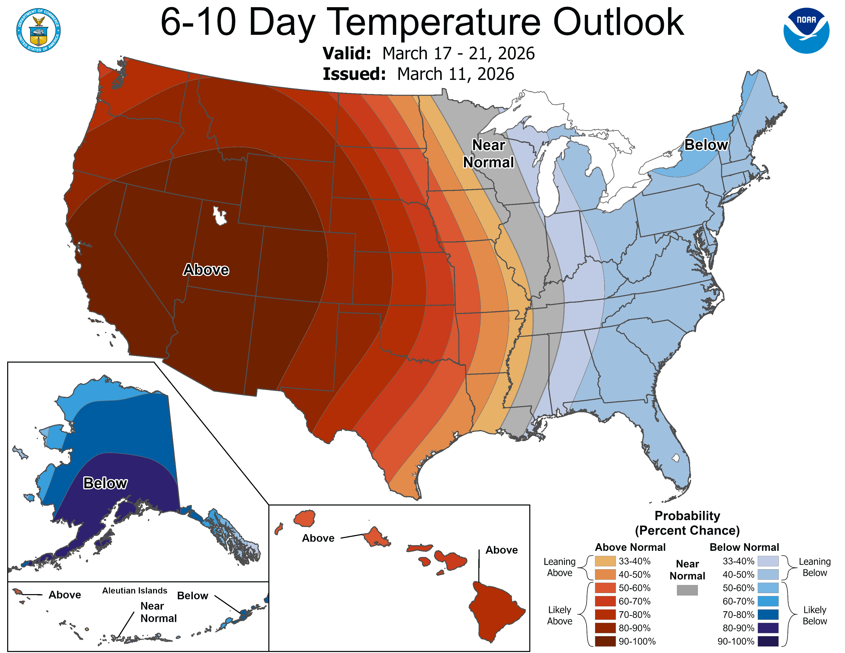
Here’s the 6-10 day forecast for March 17-21. We’ll see generally colder than average temperatures east of the Mississippi River and warmer than average temperatures for areas west of the Mississippi River. Keep in mind this is a summary for 5 days. Near normal could mean colder than average for the first 2 or 3 day and warmer than average for the latter 2-3 days. Also note the very cold pattern for Alaska.
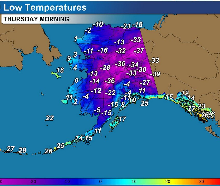
Here’s forecast low temperatures for Alaska for this Thu. AM. The -41 at Fairbanks Wednesday morning tied a record low temperature and was 34 degrees colder than average. Anchorage reach -2 and that was 19 degrees colder than average.
In other news: Heavy rain will fall in Hawaii. There’s a flood watch out for all the islands with a Winter Storm Watch for the high mountains of the Big Island.
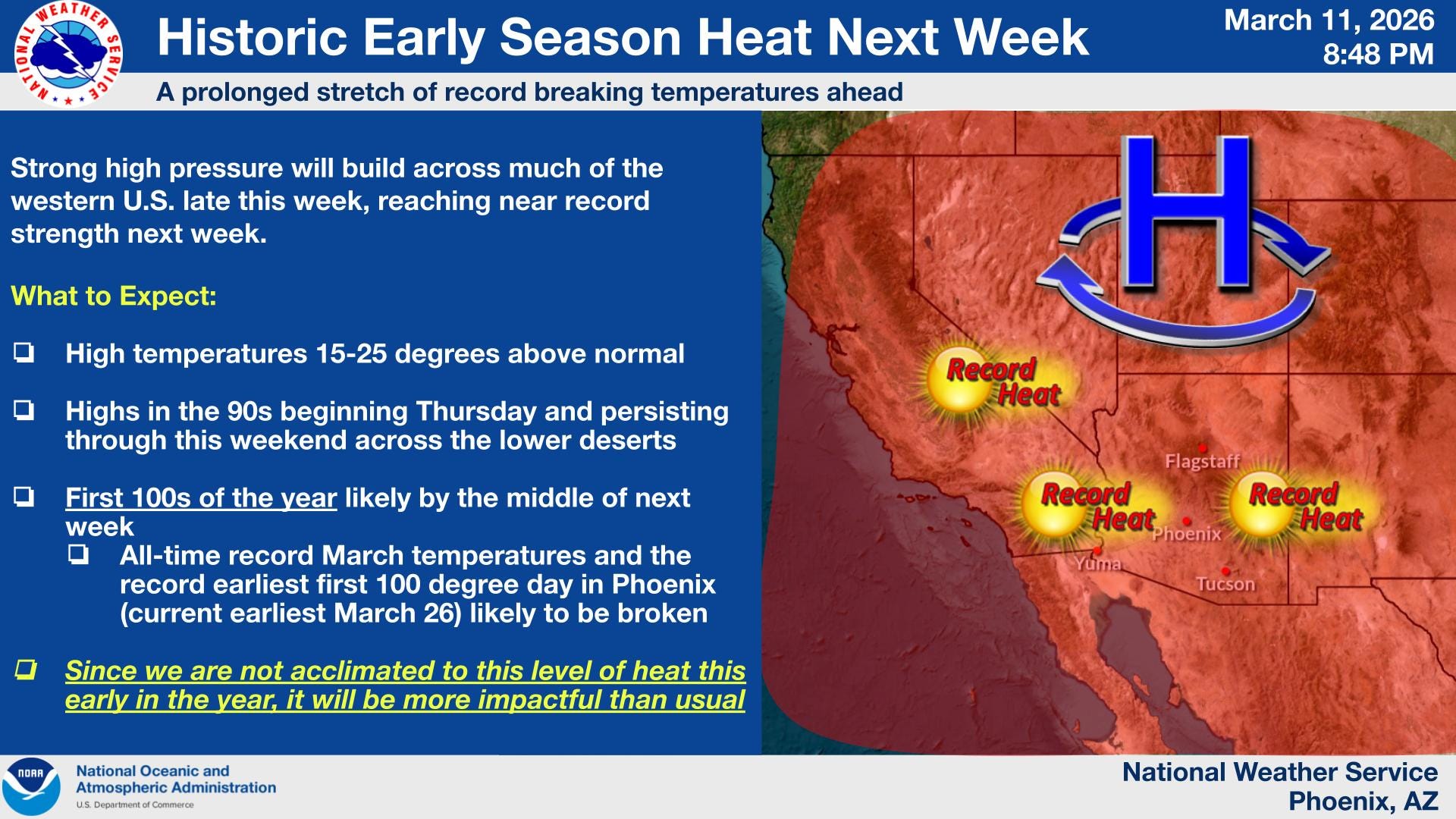
And…the heat is on in the Southwest. Temperatures will soar above 100 in the desert areas of southern Arizona and southeast California.
Meteorologists will have a lot to talk about over the next few days.
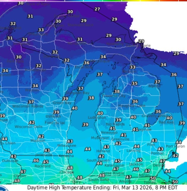
Here’s high temperatures for tomorrow (Fri.). Temperatures will reach the low 40s around Grand Rapids, upper 40s south of I-94 and only in the low 30s in the U.P.
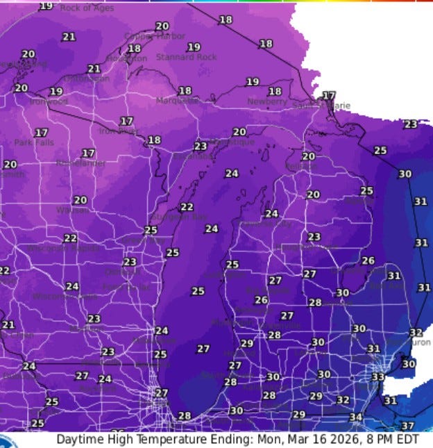
Here’s high temperatures for Monday. It’ll be a cold and windy day with snow. Temperatures during the day will be in the mid-upper 20s, a good 15 degrees colder than average. Only a few degrees warmer on St. Patrick’s Day.
Uncle!!!!
Wow thank you for your detailed post. Topsy-turvy intense MI weather onece again.