
Gulf Coast Snowstorm - Incredible
Record cold and Record Snowfall from SE Texas to NW Florida

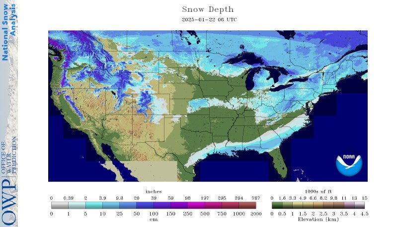
This map shows where there was snow on the ground Thursday. You can see the snow on the ground from southern Texas to eastern North Carolina. A significant strip of +4” is visible from Louisiana to Georgia. There was more snow on the ground in Florida than there was in Iowa or southern Wisconsin.
You can also see the snow left from the storm last week that moved east from Kansas to New England. We have snow on the ground in West Michigan, but none across the lake in eastern Wisconsin. Muskegon had 10” of snow on Thursday, bringing their season total to 54.4”. On the other side of Lake Michigan, Milwaukee WI has had just 11.8” of snow this season. You can see that most of our snowfall has been lake-effect.
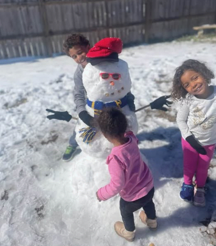
This picture is from Laura in Panama City, Florida. Her kids made a happy, Florida snowman. It’s been fun reading about the children (and the dogs) that had never seen snow before.
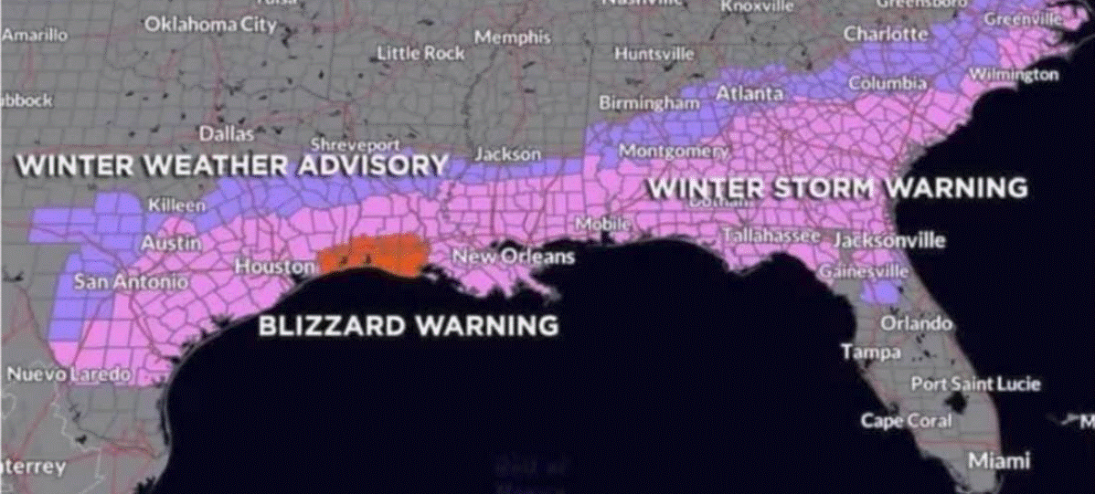
Winter Storm Warnings stretched from the Rio Grande River to the Outer Banks of North Carolina. We had the first ever Blizzard Warning for far SE Texas and southwest Louisiana. A blizzard actually verified for the lakefront airport in New Orleans, where they had 3 hours of heavy snow and winds gusting to over 35 mph. They actually were getting lake-enhanced snow with a wind off Lake Ponchartrain.
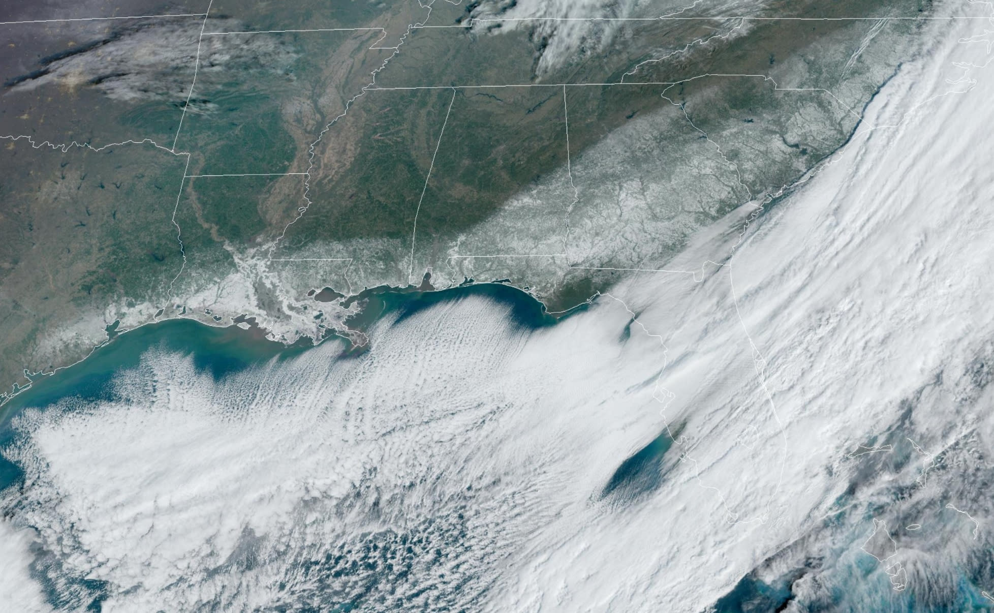
Here’s a satellite picture taken Thursday Jan. 22. You can see lots of clouds over the Gulf of Mexico. Some of this cloudiness is ocean-effect clouds - same thing as lake-effect clouds in Lower Michigan. They are caused by very cold air coming over the warmer water.
Note the strip of snow on the ground from SE Texas east to northwest Florida and then northeast up to north Carolina. New Orleans received 10” of snow. Despite full sunshine, they still had 6” of snow on the ground early Friday morning. The high temperature on Thursday was 33 and that was 30 degrees cooler than average.
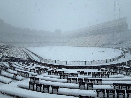
This is what the LSU football stadium looked like during the snowstorm. Lafayette LA had a low temperature Thursday morning of 4 above zero! That was 40 degrees colder than average! Mobile AL had 7.5” of snow. They still had 3” of snow on the ground early Friday morning and they had a low temperature of 6 above zero early Thursday.
...Selected preliminary Storm Total Snowfall in inches from 700 AM
EST Tue Jan 21 through 900 AM EST Tue Jan 21...

...ALABAMA...
BABBIE                               11.0
SPANISH FORT                          9.5
TURKEY BRANCH                         9.5
BECK                                  9.3
ORANGE BEACH                          8.8
SILVERHILL                            8.5
CLAY CITY 1 S                         8.0
MOBILE REGIONAL ARPT                  7.5

...FLORIDA...
MILTON                                9.8
MOLINO 1 NE                           9.5
PACE                                  9.0
BELLVIEW 1 W                          8.0
ORIOLE BEACH 2 ENE                    8.0
PENSACOLA BEACH                       7.5
CRESTVIEW                             5.5
DOWNTOWN PENSACOLA                    5.0

...GEORGIA...
PALMYRA                               7.8
ATTAPULGUS                            7.0
DONALSONVILLE                         7.0
SAVANNAH                              3.0
AVONDALE 1 NE                         2.5
BARNESVILLE                           1.5
COVINGTON 2 SE                        1.3
HARLEM                                1.3
FAYETTEVILLE 1 E                      1.0
...LOUISIANA...
CHALMETTE 1 SE 11.5
LAFAYETTE 1 S 10.5
RAYNE 10.5
DES ALLEMANDS 2 W 10.0
METAIRIE 2 E 10.0
NEW ORLEANS 2 SSE 10.0
LAFAYETTE 9.5
MAURICE 4 N 9.3
LONG BEACH 1 SE 9.0
OAK HILLS PLACE 9.0
EUNICE 8.3
BATON ROUGE 3 SSW 8.0
CROWLEY 8.0
GRAND LAKE 8.0
LAKE CHARLES 6.0
KENNER 4.0
...MISSISSIPPI...
LEAKESVILLE 4.0
LUMBERTON 4.0
WIGGINS 3.5
SANDY HOOK 3.0
...NORTH CAROLINA...
WRIGHT BROTHERS NATIONAL 9.0
HATTERAS ISLAND 8.0
GRANDY 7.5
INDIAN BEACH 6.0
MOREHEAD CITY 5.0
ODGEN 4.5
RALEIGH 4 SSW 1.1
RALEIGH-DURHAM INTL ARPT 1 NNW 1.0
CENTER CITY CHARLOTTE 4 SW 0.4
...SOUTH CAROLINA...
FORESTBROOK 4.5
HANAHAN 4.0
SUMMERVILLE 3.5
GLOVERVILLE 1 E 1.4
JOHNSTON 2 N 1.1
...TEXAS...
LA PORTE 2 SE 6.0
PINE FOREST 6.0
MAURICEVILLE 5.5
NEDERLAND 4 W 5.5
BEAUMONT 5.2
BAYTOWN 2 WSW 5.0
SE HOUSTON 4.0
NATIONAL WEATHER SERVICE NEW ORLEANS LA
709 PM CST WED JAN 22 2025
NATIONAL WEATHER SERVICE LAKE CHARLES LA
1007 AM CST WED JAN 22 2025
..SNOWFALL REPORTS
LOCATION AMOUNT TIME/DATE PROVIDER
GRAND COTEAU 2.3 SSE 13.4 IN 0700 AM 01/22 COCORAHS
RAYNE 1.0 W 11.4 IN 0700 AM 01/22 COCORAHS
CHURCH POINT 5.2 SSE 11.0 IN 0700 AM 01/22 COCORAHS
1 S LAFAYETTE 10.5 IN 0100 PM 01/21 PUBLIC
3 S BRANCH 10.5 IN 1051 AM 01/21 AMATEUR RADIO
BREAUX BRIDGE 0.7 NNW 10.0 IN 0700 AM 01/22 COCORAHS
1 SSW SCOTT 10.0 IN 0340 PM 01/21
LAFAYETTE 9.5 IN 0128 PM 01/21 BROADCAST MEDIA
4 N MAURICE 9.3 IN 0509 PM 01/21 PUBLIC
1 WSW LAFAYETTE 9.2 IN 0600 AM 01/22 COCORAHS
2 WNW CARENCRO 9.0 IN 0200 PM 01/21 PUBLIC
3 NE MILTON 9.0 IN 0215 PM 01/21
EVANGELINE 9.0 IN 1210 PM 01/21 EMERGENCY MNGR
BRANCH 0.4 SSW 9.0 IN 0800 AM 01/22 COCORAHS
1 E DUSON 8.5 IN 0433 PM 01/21 PUBLIC
EUNICE 8.3 IN 1118 AM 01/21 LAW ENFORCEMENT
ST. MARTINVILLE 0.2 S 8.1 IN 0700 AM 01/22 COCORAHS
1.7 S JENNINGS 8.1 IN 0600 AM 01/22 COOP
YOUNGSVILLE 8.0 IN 1035 AM 01/21 AMATEUR RADIO
3 NW LYDIA 8.0 IN 0510 PM 01/21 PUBLIC
GRAND LAKE 8.0 IN 1238 PM 01/21 EMERGENCY MNGR
1 E CROWLEY 8.0 IN 1155 AM 01/21 PUBLIC
MORSE 8.0 IN 0626 PM 01/21 PUBLIC
..JANUARY 22ND 2025 LOW TEMPERATURE REPORTS
LOCATION TEMP TIME/DATE PROVIDER
NEW ROADS 4 F 0735 AM 01/22 AWOS
ST. FRANCISVILLE 1 NE 5 F 0730 AM 01/22 COOP
PASCAGOULA TRENT LOTT INTL 7 F 1153 AM 01/22 ASOS
GULFPORT-BILOXI INTL AIRPORT 7 F 1153 AM 01/22 ASOS
BATON ROUGE AIRPORT 7 F 1153 AM 01/22 ASOS
MC COMB-JOHN E. LEWIS AIRPOR 8 F 1153 AM 01/22 ASOS
SLIDELL AIRPORT 8 F 0658 AM 01/22 ASOS
GONZALES 8 F 0715 AM 01/22 AWOS
HAMMOND 10 F 0735 AM 01/22 AWOS
THIBODAUX 4 SE 10 F 0800 AM 01/22 COOP
SLIDELL 1 SE 11 F 0800 AM 01/22 COOP
3 SSE PICAYUNE 12 F 0735 AM 01/22 AWOS
BOGALUSA CARR F 12 F 0715 AM 01/22 AWOS
RESERVE 13 F 0715 AM 01/22 AWOS
BELLE CHASSE 13 F 1155 AM 01/22 AWOS
BILOXI KEESLER 17 F 0655 AM 01/22 AWOS
GALLIANO 19 F 0155 AM 01/22 AWOS
NNEW ORLEANS INTL-LOUIS ARMST 23 F 1153 AM 01/22 ASOS 
New Iberia LA reported a low temperature Thu. AM of +2 - that was 41 degrees colder than average for the date AND it broke the old record low temperature for the date by 20 degrees! Infra-red satellite pics. indicated that there was a small area in LA where the temperature was briefly below zero!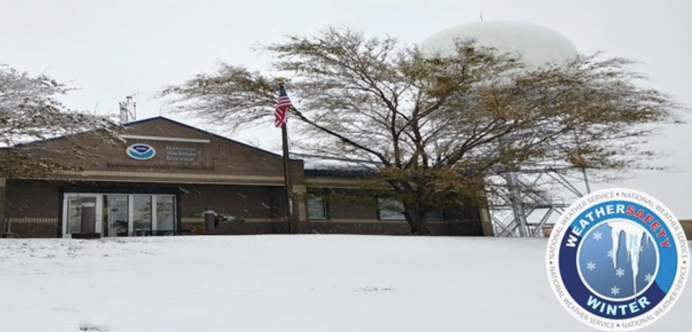
  Here's the Lake Charles Louisiana National Weather Service Office - about 4" on the ground here.

Here's a Florida snowplow...a frozen alligator under the ice...video of the blizzard on the south shore of Lake Ponchartrain Wed. PM 1 21 25 from Zach Fradella. Drone shot of the snow at Pensacola Beach. I've vacationed here several times.  The last time, we hit a day in the mid-upper 70s in December and I went swimming in the Gulf of Mexico.