
Great Lakes Storm Update
Snow, cold, some drifting snow and slick spots on area roads

We have a Winter Weather Advisory for the Lakeshore Counties and the next set of counties inland (including Grand Rapids and Kalamazoo. Look for 2-5” of new snow, along with fairly strong winds, some drifting snow and slick spots on the roads. Here’s the links to the National Weather Service forecast discussions for West Michigan, East Michigan, Northern Lower Michigan, Northern Indiana and Upper Michigan.
The Winter Weather Advisory runs 11 am Tuesday. We also have a Wind Advisory in effect until 11 pm tonight for gusts up to 40-50 mph.
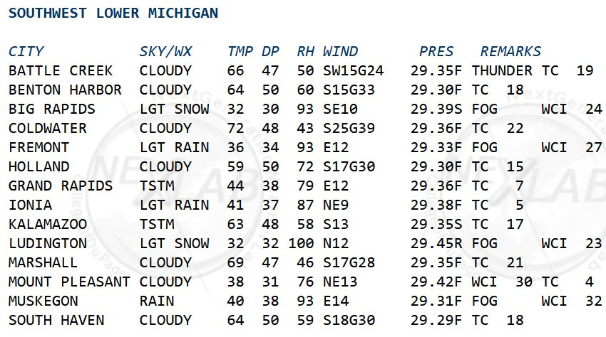
These are weather observations from 6 pm Sunday. Coldwater was 72, while Big Rapids was 32 - a 40 degree difference! Coldwater had a strong south wind at 25 mph with gusts to 39 mph, while Ionia’s wind was northeast at 9 mph. That’s some heavy duty surface air convergence. Warm, moist air lifted and we got numerous showers and a few thunderstorms (nothing severe in MI.). Looking at the operations, it was 59 in Holland and 40 in Muskegon…easy to tell where the front was located.
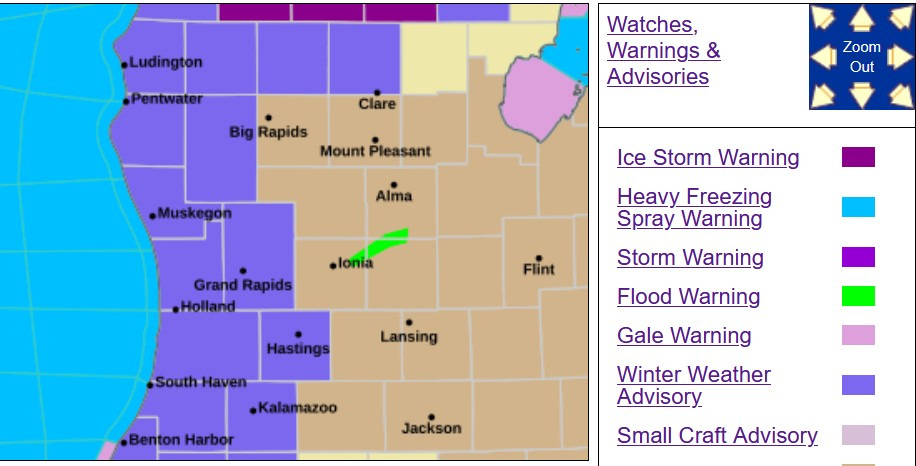
Here’s the Advisory Graphic for West Michigan as of early Sunday. The counties in purple have a Winter Weather Advisory until 2 pm for 1-3” of snow and the possibility of up to 1/10th inch of freezing rain. The counties in tan have a Wind Advisory from 11 am this Sunday to midnight for gusts to 40-50 mph.
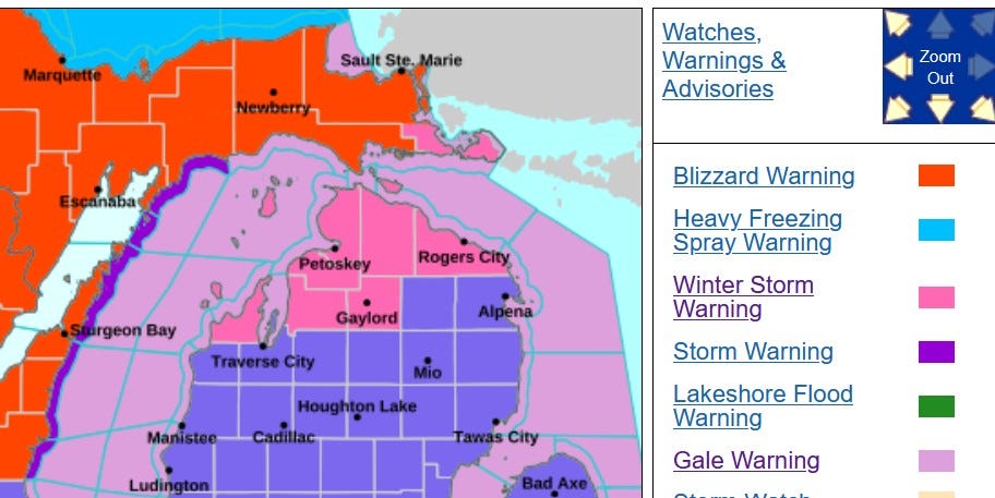
Here’s the Advisory Map for N. Lower and E. Upper Michigan. There is a separate threat on the U.P. Blizzard (1-3 FEET of snow expected in the U.P.
There is a Winter Storm Warning for Leelanau, Antrim, Emmet, Charlevoix, Otsego, Charlevoix and Presque Isle Counties until 8 am Monday for 6-14” of snow, up to 1/2” of freezing rain and treacherous driving conditions. Wind gusts to 45 mph are possible.
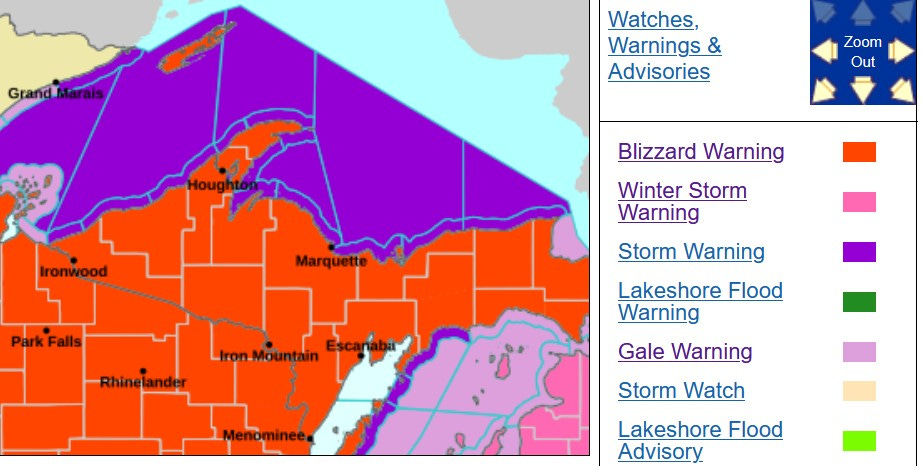
All counties in Upper Michigan have been under Blizzard Warnings through today. The Marquette NWS says: “Heavy snow expected. Blizzard conditions possible. Total snow accumulations between 1 and 3 feet possible. Whiteout conditions are expected and will make travel treacherous and potentially life-threatening.” Sunday night, I saw Spaulding had already recorded 26” of new snow and Newberry had 23”.
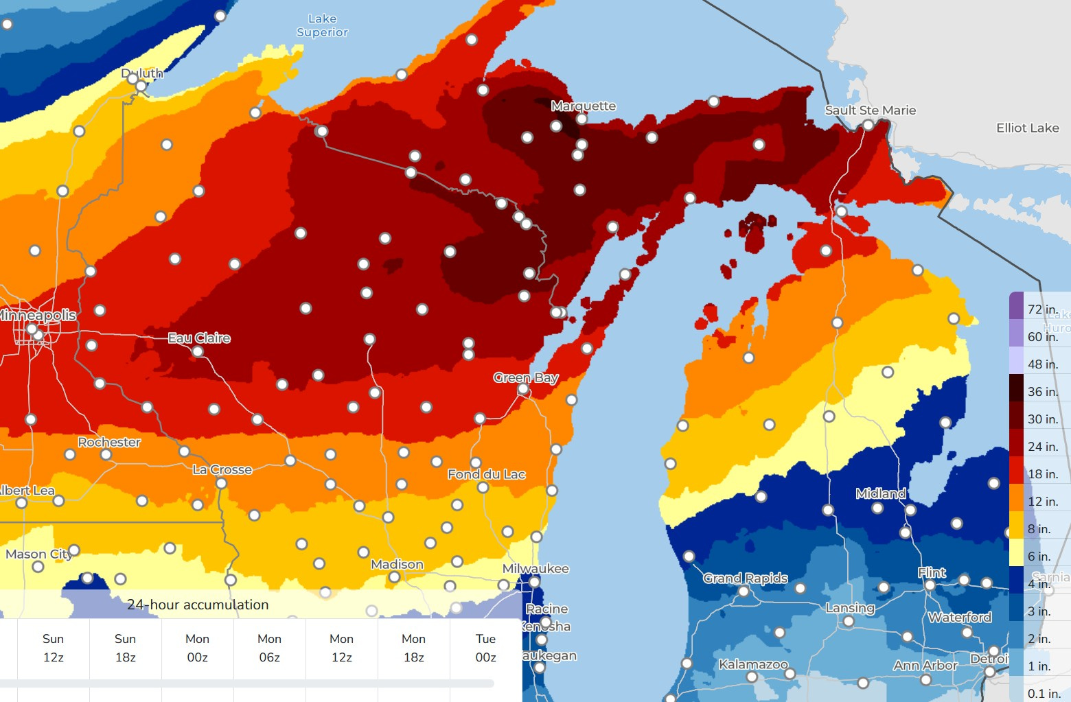
Here’s forecast snowfall. Note the legend on the far right. The darkest red is +30” of snow in 2 1/2 days…and Marquette just HAD +11” snow! Much less snow south of Grand Rapids and than may not come until we get the cold air during Monday/Tuesday.
This PM/tonight, we’ll have to watch out for severe weather. It will already be windy on Sunday and it may not take much for any storms to bring strong wind gusts to ground level.
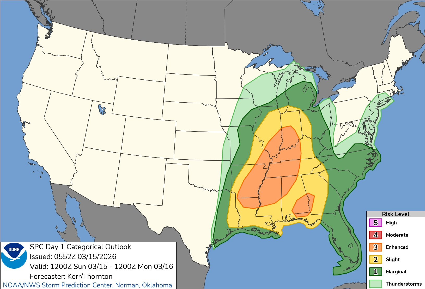
This is the updated (at 2 am) Severe Weather Outlook Map for this PM/night. There is a relatively large Enhanced Outlook Area (in orange on the map above) from Louisiana to Indiana. That’s surrounded by a Slight Risk Area (in yellow on the map, level 2) from far SW Michigan to the Gulf of Mexico/America. The Marginal Risk (level 1) in dark green on the map extends north to Ludington and Houghton Lake.
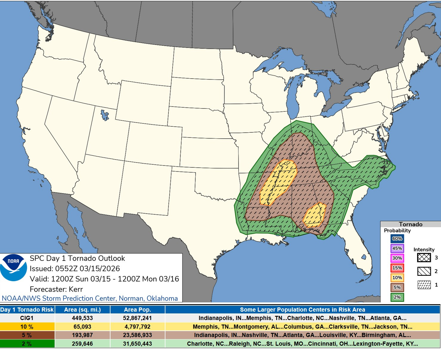
Here’s the Tornado Outlook Map from SPC for Sunday PM/night. The greatest threat is from Indianapolis to northern Louisiana. (Remember I’ve written about La Nina patterns favoring storminess in the Ohio and mid-Mississippi River Valleys). Michigan has been taken out of the tornado outlook (good news).
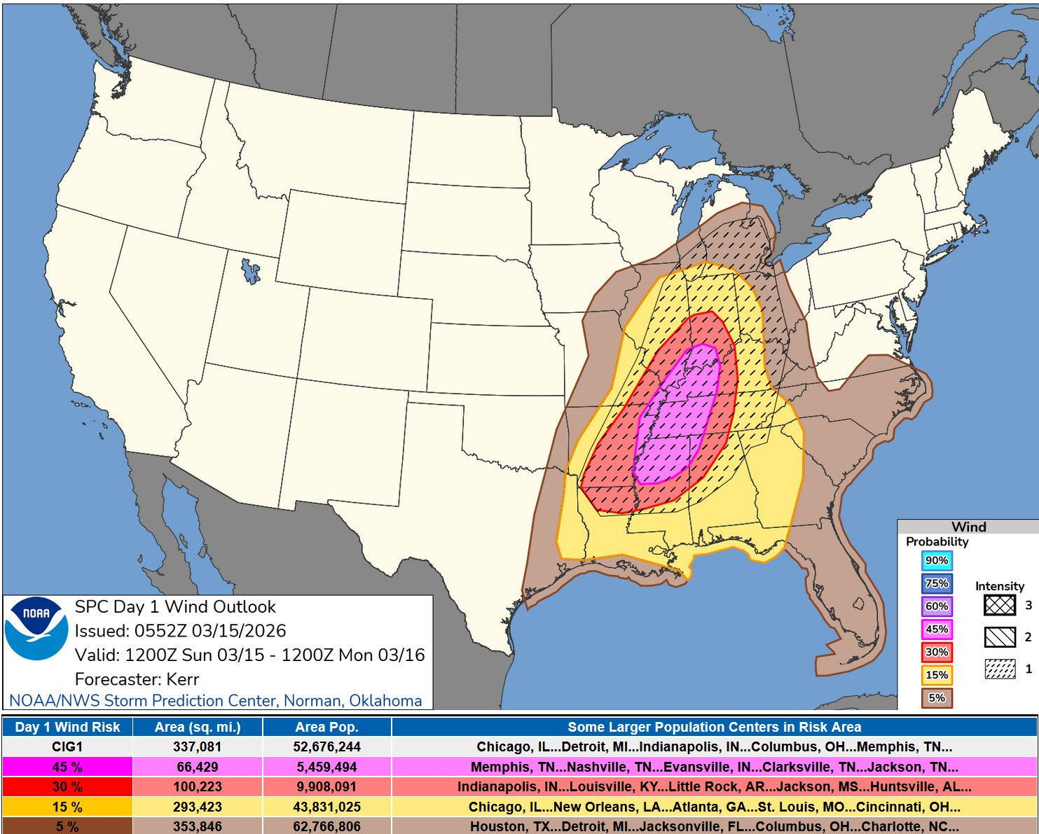
Here’s the Sunday PM/night Severe Wind Map. This will be the main threat with a 15% chance of a severe report within 25 miles of a given point in southwest Michigan. The Grand Rapids NWS writes: “A VERY STRONG LOW-LEVEL WIND FIELD AND PRE-MIXED NEAR-SURFACE LAYER MEANS IT WON’T TAKE MUCH TO BRING DOWN SEVERE WIND GUSTS OVER 58 MPH.”
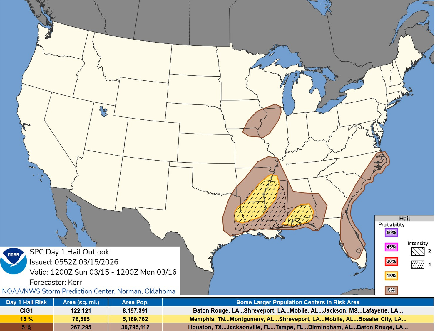
This is the Severe Hail Outlook from SPC for Sunday PM/night. The good news is that it’s unlikely that we’ll have any significant hail in West Michigan, like we had last Tue. evening.
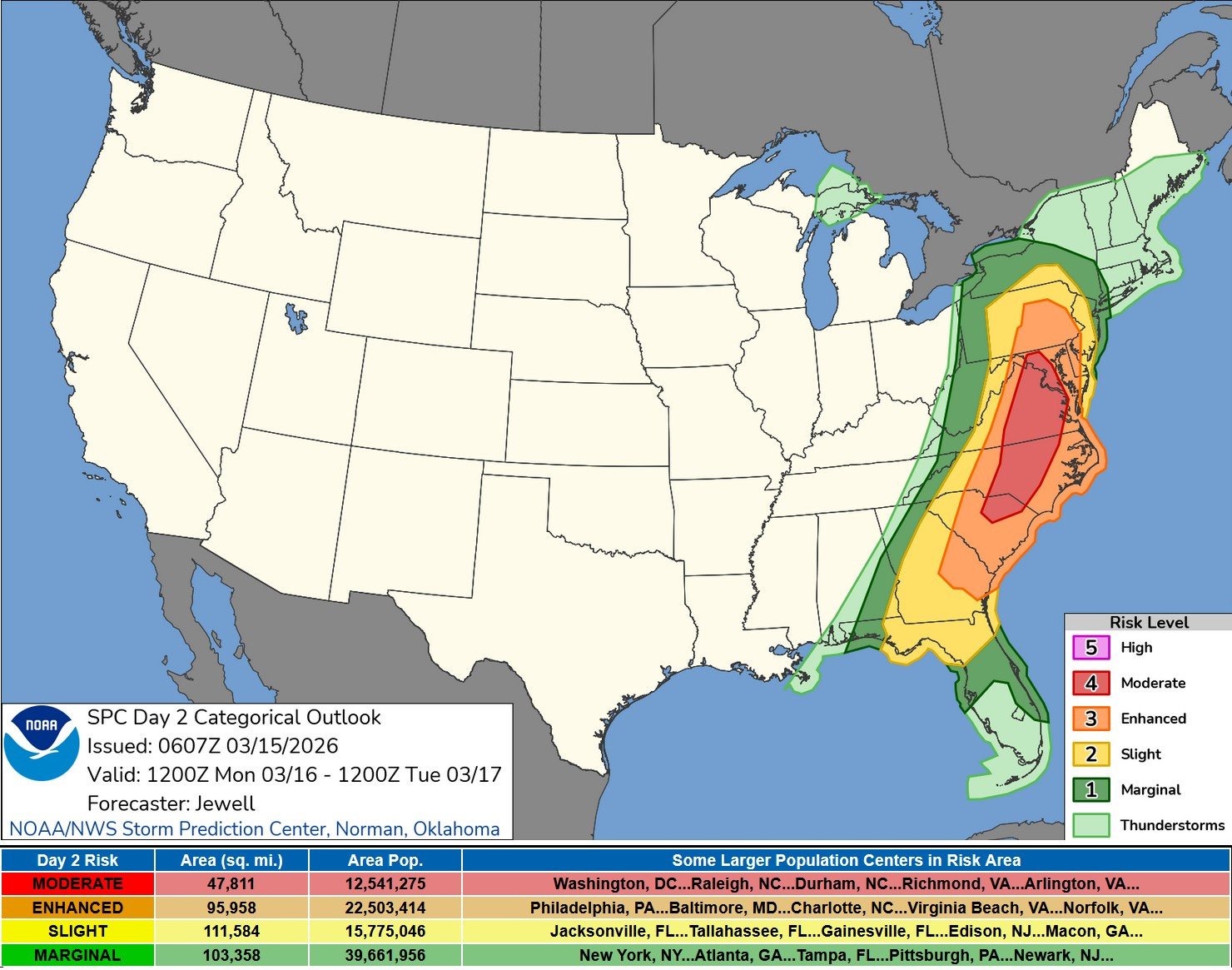
This is the Severe Weather Outlook Map for Monday. There’s a Level 4, Moderate Outlook - in red on the map - from South Carolina to Maryland. There’s the possibility of tornadoes and significant wind damage. Anyone in that area Monday should pay close attention to the latest forecast.
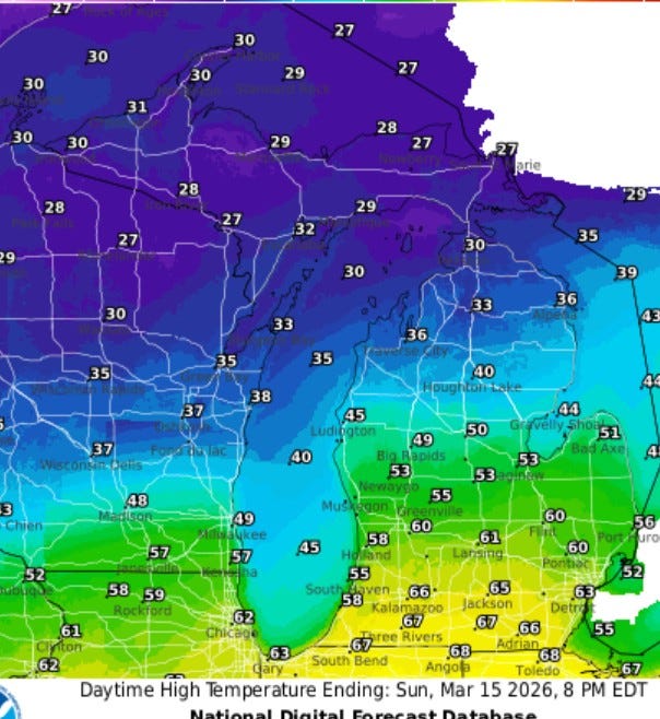
Today we’ll have a large temperature difference from south to north across Lower Michigan. It could come close to 70 at the Indiana border, maybe low 60s for highs along I-96. It may not get out of the 40s at Big Rapids and Ludington with low-mid 30s in far northern Michigan where the snowflakes will be flyin’. It will also be quite windy again Sunday PM and Monday.
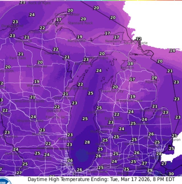
These are the forecast high temperatures for St. Patrick’s Day (Tue.). Does green beer freeze? We may have to have Cedar Springs make green flannel instead of red flannel. Just mid 20’s in the afternoon Tuesday. They will still be digging out in the U.P. and N. Lower Michigan on Tuesday.
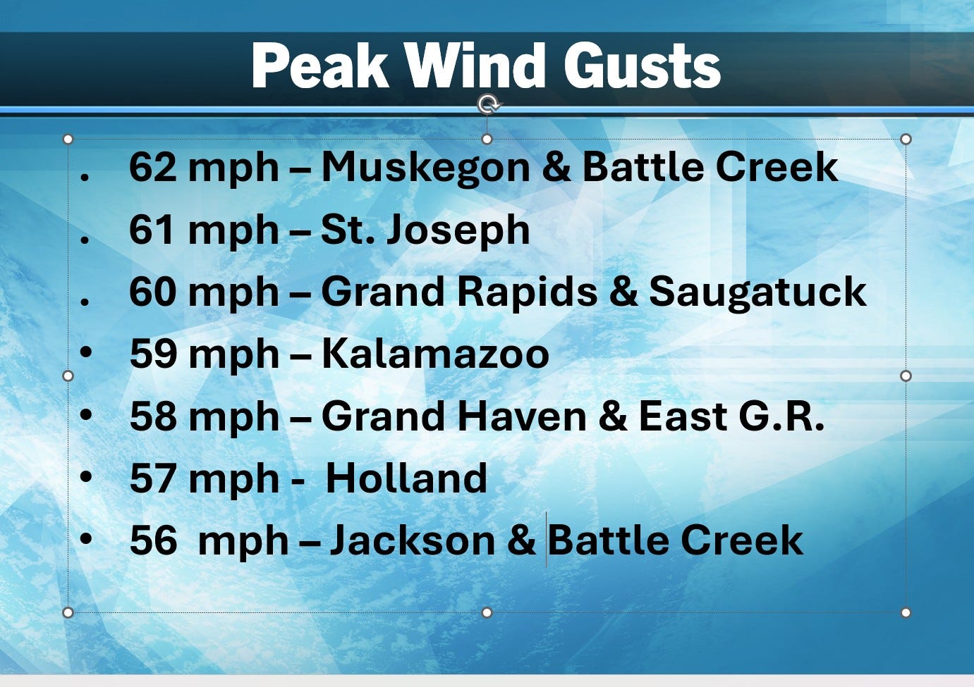
Here’s peak wind gusts in West Michigan on Friday. Nearly 60,000 Consumers Energy customers were without power. Remember that power companies can’t get up in the buckets to fix wires until the winds die down.
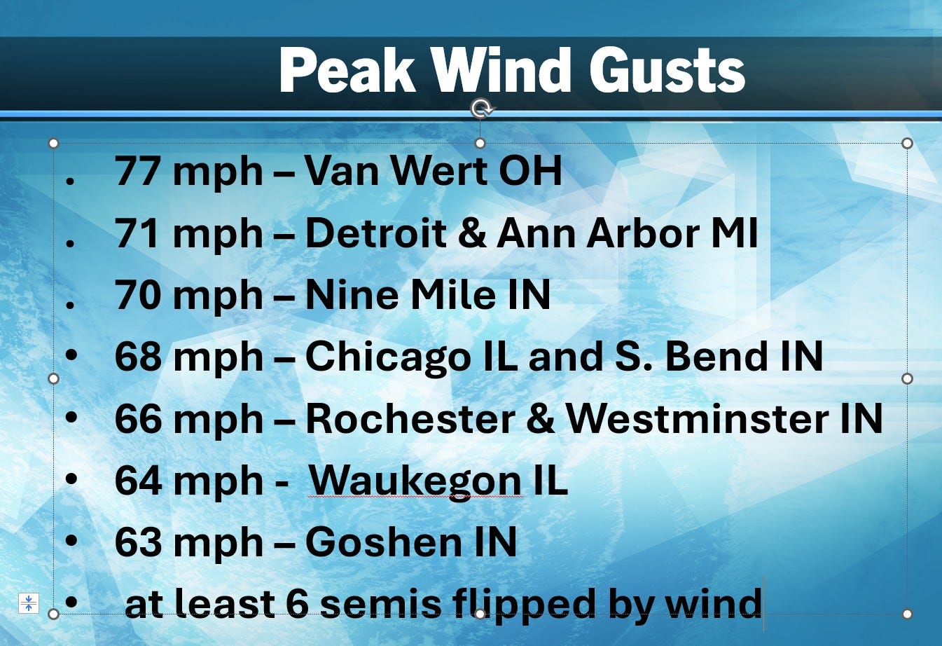
Look at these wind gusts Friday! 58 mph is a severe storm.
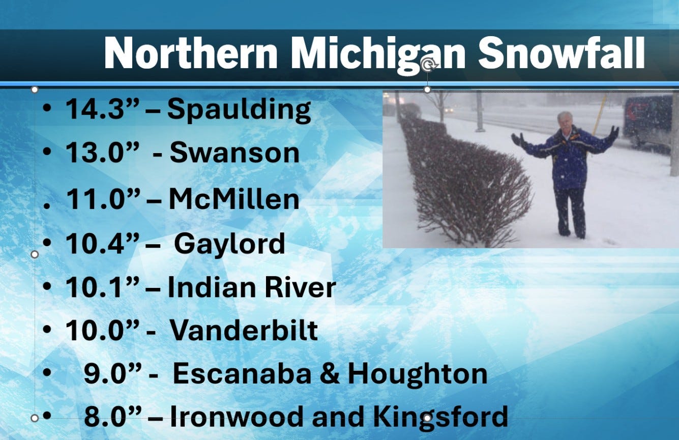
This is snowfall from Thurs. night and Friday…these people hardly have time to shovel and plow out before this even BIGGER storm arrives this weekend.
I’ll update this thread and the Blizzard Thread later this Sunday.
Thank you
Thanks Bill! Unique scary weather we've been having. Stay safe everyone. 🙏