
Hard Freeze Early Monday
We've had a hard freeze Monday morning.

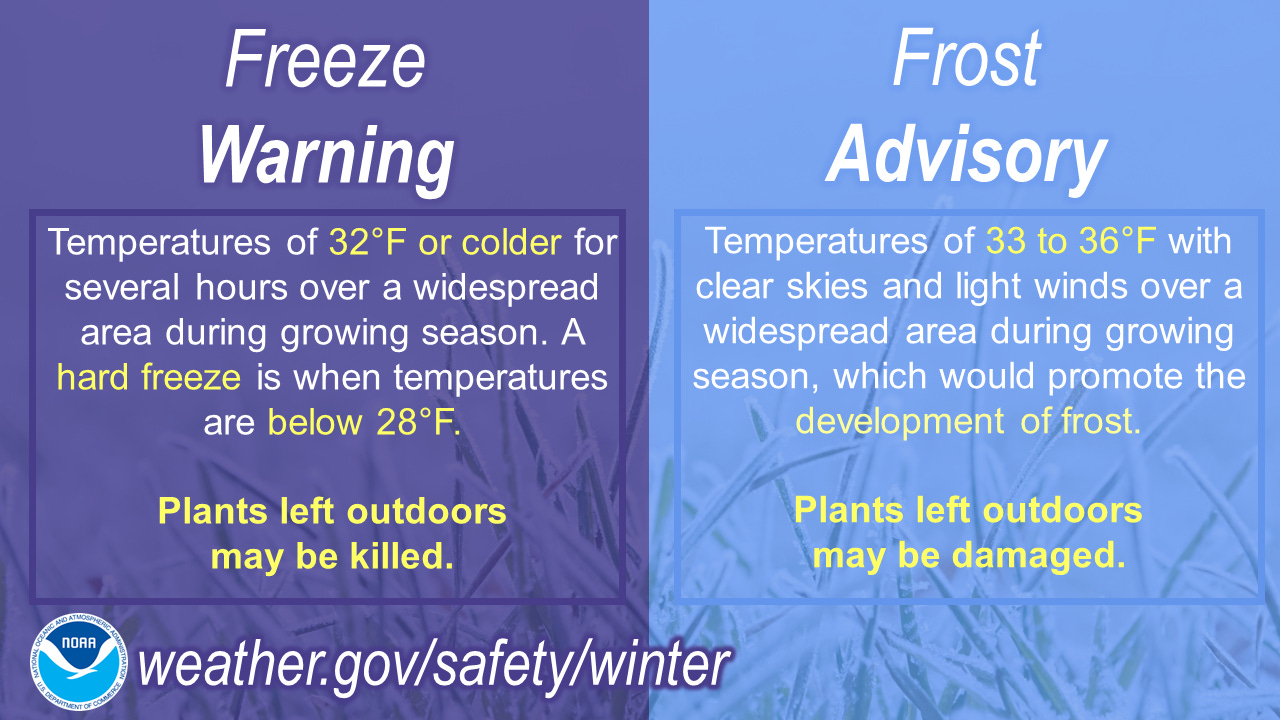
A Freeze Warning has been in effect this Monday morning. Most low temperatures are bottoming out in the mid-upper 20s. With mostly clear skies and calm or nearly calm winds, lakeshore areas could be just as cold as inland areas this Monday AM.
Tuesday morning there could be some scattered, mainly light frost, but after that I don’t see any more frost the rest of this week into early next week.
The past couple nights we’ve been enjoying a waxing (more of the moon is visible each successive night) crescent moon. The bright star to the west in the evening is the planet Venus. To the left in the southwestern sky is the planet Jupiter.
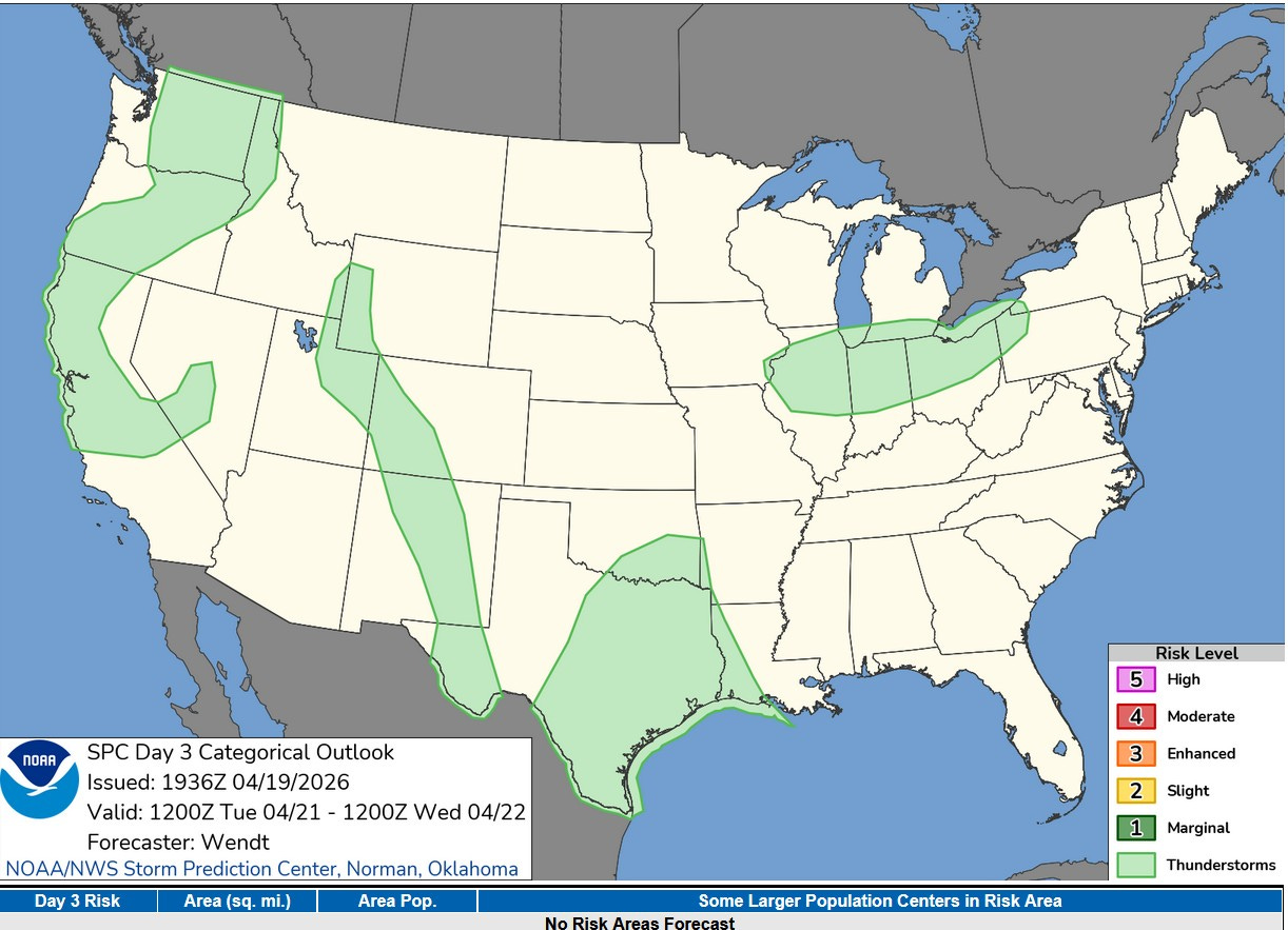
This is the Severe Weather Outlook Map for Tuesday/Tuesday night No areas outlined for severe weather, but they have outlined an area with a chance of a non-severe thunderstorm from Illinois to NW Pennsylvania…in Michigan that’s along and south of I-94.
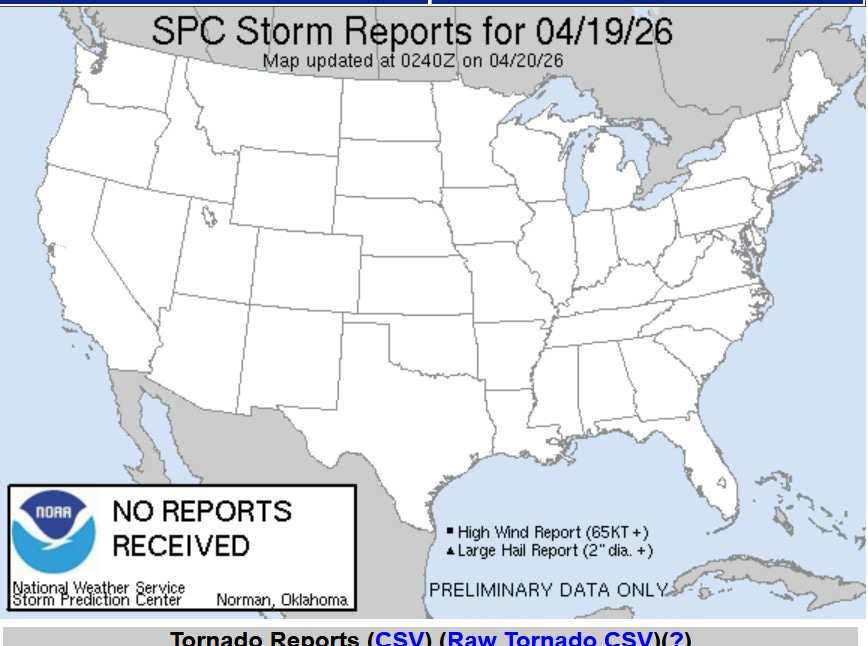
Here’s some good news…there were no reports of severe weather anywhere in the U.S. on Sunday…none…zip…nada!
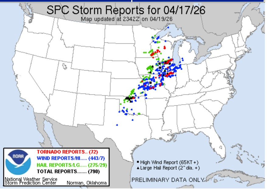
Contrast Sunday to last Friday. We’re up to 790 severe report from Friday PM/night, including 72 tornadoes. It’s amazing how the weather pattern can change in just a few days. The 790 severe reports looks like the most severe reports in a single day since 5/26/2024, or nearly two years ago.
We had 3 wind damage reports in SW Michigan…near Watervliet, Plainwell and a 3 mile long damage path near Moline.
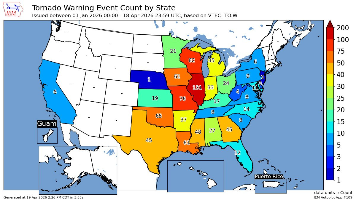
Here’s tornado warnings by state so far this year. Illinois has the most, Wisconsin is in 2nd place. Michigan has issued nearly twice as many tornado warnings as Kansas. California has issued 6 tornado warnings compared to just 1 in Nebraska. Pretty weird.
Wisconsin had 23 tornadoes last week. They average 23 during an entire year. Three of those 23 tornadoes last week were EF3. Up until last week, Wisconsin had just 4 EF tornadoes in the last 15 years combined!
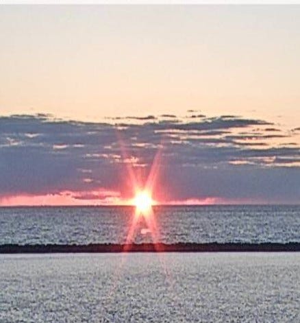
Here’s a look at sunset at Muskegon Sunday evening (4/19). The water temperature at the Holland Channel was up to 56 on Sunday. At the Port Sheldon buoy, the water tremperature is 54 and at the Muskegon buoy it’s 53. The Reeds Lake water temperature is 52.
Sunrise is at 6:52 AM and sunset at 8:30 pm. Daylight continues to increase at the rate of around 2 1/2 miles per day. The average high temperature in Grand Rapids reaches 60 degrees today, the average low temperature is now 39.
Sunday’s high temperatures ranged from 51 at Battle Creek and Kalamazoo to a chilly 29 at Sault Ste. Marie. Grand Rapids peaked at 47. It was cooler at the lake with highs of 42 at the Holland Beach and Holland Beach and 41 at the Muskegon Beach.
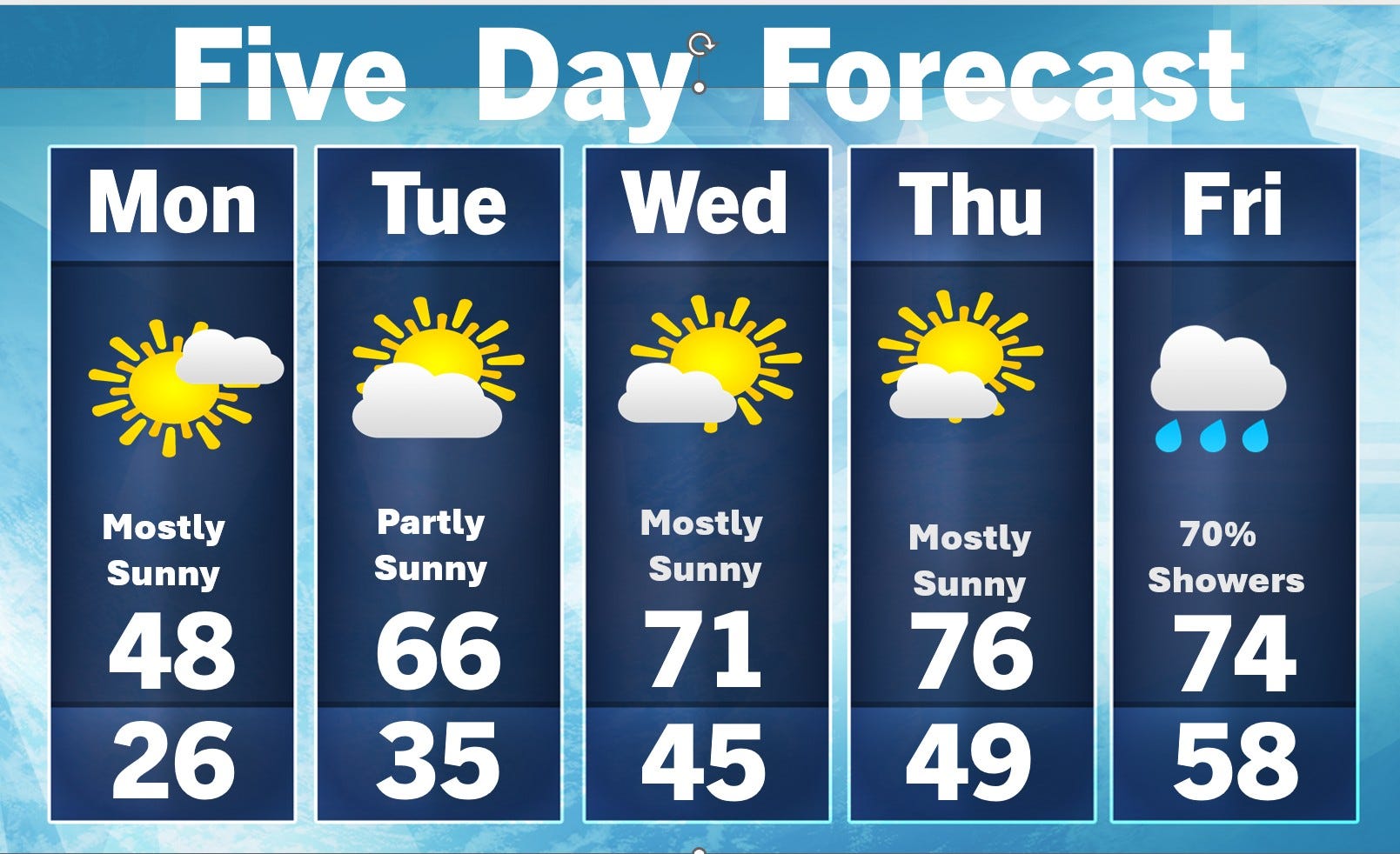
Here’s the 5-day forecast. It’ll be dry Monday - Thursday, with showers and maybe thundershower late Thursday night and Friday. There’s maybe a 20% chance of a shower or thundershower Tuesday PM along and south of I-94. It’ll be cool today, but with sunshine and relatively light winds (W-SW 5-10 mph) it’ll be a nice day. Then we warm up above average again Tuesday afternoon.
Friday/Friday night there were 150 tornado warnings issued in the contiguous U.S. and 311 severe thunderstorm warnings.
After a cool start to Tuesday, temperatures are headed above average again Tuesday afternoon and beyond. We should see a dry 5 days giving river levels a chance to go downward. Grand Rapids has had 2 1/2 times average rainfall (252%) since March 1.
There is still snow on the ground in the Keweenaw Peninsula and from their east to near Sault Ste. Marie. Marquette (airport) still had 9” of snow on the ground Saturday AM. They have had 274.7” of snow this season and that’s 83.8” above average. Sault Ste. Marie has had 188.6” of snow this past winter and that’s 70.6” above average.
Also: Physics is phun. Floodwaters in downtown Grand Rapids. Winter is certainly not over in Canada.
How far up is Lake Michigan since March 1?
Thanks Bill as always for keeping us informed