
El Nino Developing

The (weak) La Nina pattern we’ve had for much of the last couple years is forecast to flip to an El Nino Pattern this late spring and summer.
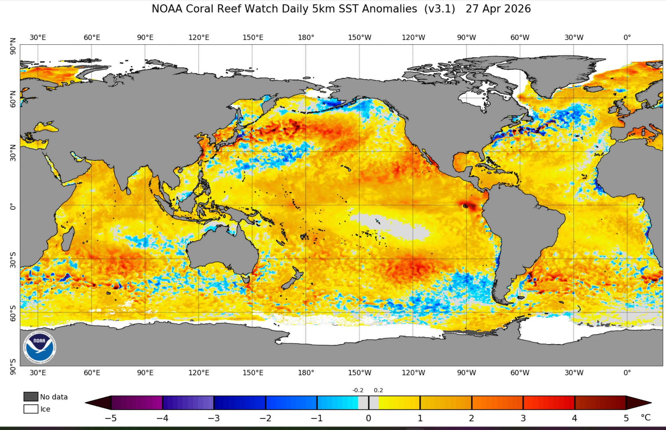
The map above shows current global sea-surface temperature anomalies, which is the difference in sea surface temperature from average.
Look along the Equator west of South America. Here we find water temperatures are a little bit warmer than average. You can also see a deep red blog of quite warm water around 90W longitude.
The Climate Prediction Center says: “ENSO-neutral conditions are present and are favored to continue through April-June 2026 (80% chance). In May-July 2026, El Niño is likely to emerge (61% chance) and persist through at least the end of 2026. ENSO stands for El Nino Southern Oscillation.
So, what does that mean for our weather. First, this is just one piece of the long-range forecast (jigsaw) puzzle. It’s not the only piece. Head to this link and this link to see a record of El Ninos and La Ninas.
When we have a very strong El Nino (1982-83 for instance), we are likely to have a warm winter with less snow. On Christmas Day in 1982, Grand Rapids had a high temperature of 65° and we had only 36” of snow that winter.
However, we’ve had some really cold and snowy winters with a weak El Nino. Look at the winters of 1976-77 (tied for coldest of the century in West Michigan) and 1977-78 (anyone remember the blizzard of Jan. 26, 1978?).
The winter of 1951-52 was a moderate El Nino and that was the snowiest winter Grand Rapids has ever had with 132.2” at the airport and 144” downtown. We had 6 consecutive days in November 1951 with record low temperatures, including lows of 6° above on Nov. 5th and 9° on Nov. 6th.
The position of the warmest water along the Equator makes a difference. Is it near the South American Coast? or out toward the middle of the Pacific?
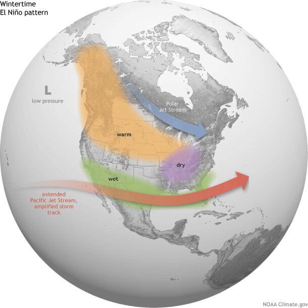
Here’s a map showing the general pattern in a year with a fairly strong El Nino. It’s generally wetter than average across the Southern U.S., even though the number of hurricanes in the western Atlantic is usually a bit below average.
There is generally dry weather across the Ohio Valley (the opposite of a strong La Nina). It’s warmer than average from eastern Alaska down to the northern Rockies, across the Midwest and Great Lakes. The warm air means less (sometimes much less) lake-effect snow. So the difference in snowfall between the Lake Michigan shore and inland areas would be less.
April is ending around 5° warmer than average and wet. May will start out cooler and a big drier than average. We’ve had 75.4” of snow in Grand Rapids this past winter. Muskegon has had 108.5”. If I were a betting man (and I’m not), I’d bet those totals will be lower next winter…but keep in mind that the average high/low temperature in Grand Rapids is 31°/19°. If we’re 5° warmer than that, then it’s 36°/24°. It’s still winter and with an average low of 24°, ski resorts will still be able to make snow at night at least some nights.
I’ll continue to track the developing El Nino. Remember, if it’s a strong El Nino - good chance of a relatively warm winter with less snow…weak El Nino and it could go either way.
saved this article! Thank you for talking about this. climate storytelling really is the need of the hour to make people aware
On my climate blog, I just wrote an article about what India, is going through officially being the hottest country on earth right now and it’s important for every country to realize why this is happening. would love your thoughts on it! https://substack.com/@susitout/note/p-199003713?r=3pcwen&utm_medium=ios&utm_source=notes-share-action
Thanks Bill!