
EIGHT Tornadoes Confirmed in Michigan
Five were rated EF1 and three were rated EF0.

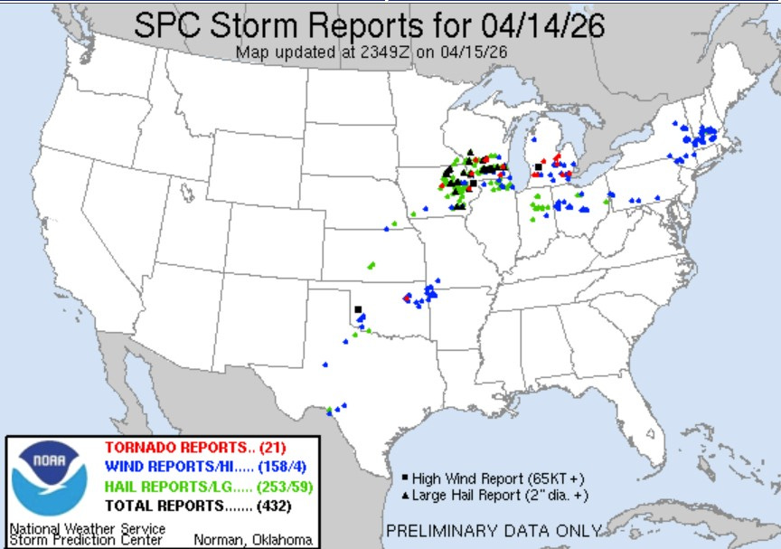
This map shows the plotted location of tornadoes, large hail and wind damage in the contiguous U.S. from 7 am on Tue. to 7 am Wed. (4/14-15/2026). There were 21 reported tornadoes in four states, including eight confirmed tornadoes in southern Lower Michigan. National Weather Service storm survey teams found 5 locations in Michigan that were hit with EF1 tornadoes (winds of 86-110 mph winds) and 3 locations where EF0 tornadoes occurred (winds of 65-85 mph winds).
There were also confirmed areas that were hit by hail and thunderstorm winds of up to 81 mph. It looks like every acre of southern Lower Michigan experienced thunderstorms, with some of the storms containing frequent lightning, continuous thunder and heavy rain that caused local flooding.
Three tornadoes were confirmed by survey team(s) that went out from the National Weather Service in Grand Rapids and five twisters were confirmed by survey team(s) from the National Weather Service in White Lake (Detroit).
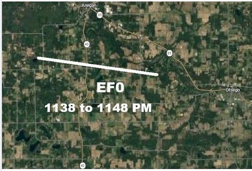
Here’s a map of the first tornado, which started four miles south west of Allegan. It moved a little south of due east, crossing M40 and lifted 4 1/4 miles west northwest of Otsego, coming close to the Bittersweet Ski Area. Peak winds with this storm were estimated to be 80 mph. The tornado downed dozens of large trees and power lines on it’s 6.5 mile path. It was approx. 100 yards wide, or as wide as a football field is long.
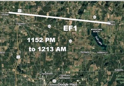
The second tornado started shortly after the first tornado lifted. This twister was an EF1 with 100 mph winds. It was on the ground for 16 miles, starting just north-northeast of Otsego and continuing all the way to Hickory Corners. The tornado crossed US 131 and put debris from a nearby building across the highway, resulting in a traffic jam both ways. It was 175 yards wide. Dozens of buildings were damaged along the tornado’s path. The tornado was moving at approximately 45 mph.
An interesting note, south of the tornado, there was some significant thunderstorm wind damage town through Otsego and Plainwell. This may have been a case of rear flank downdraft. It would be interesting to have a temperature and pressure trace from near Otsego and also to know if it was raining and how hard it may have been raining during the strong wind in Otsego.
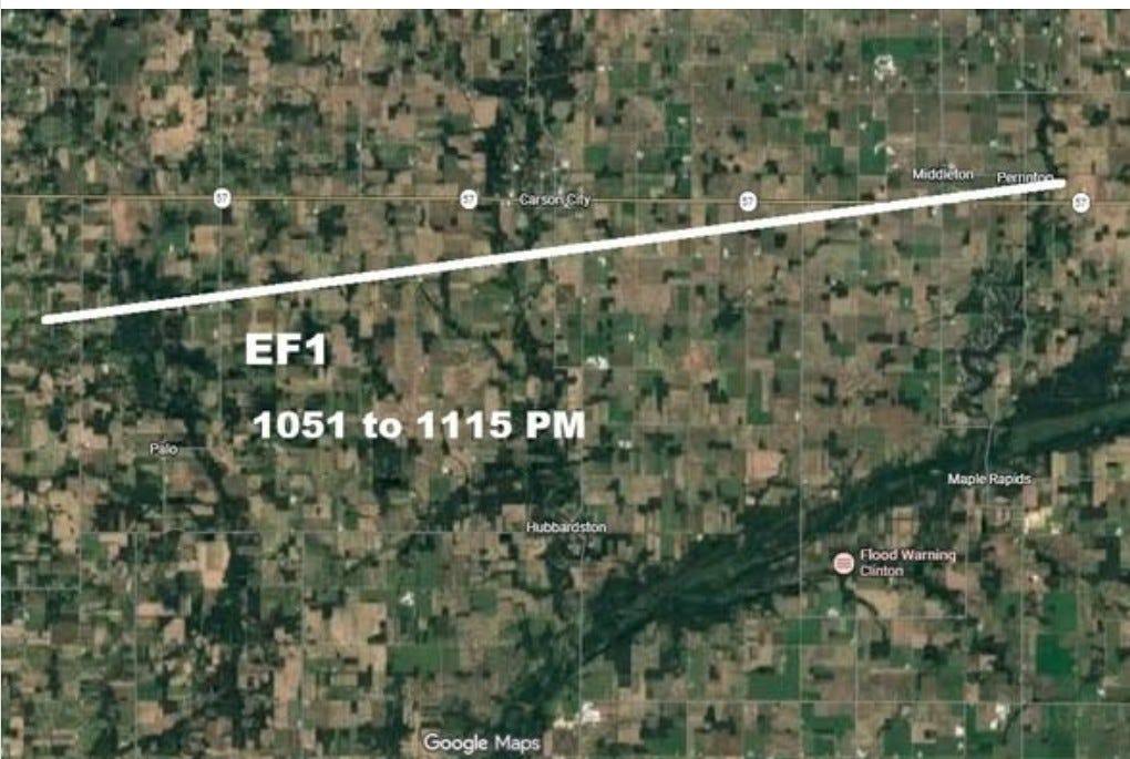
The third tornado was a strong EF1 with winds of 110 mph. Now 111 mph is EF2, so this was a significant tornado. It was on the ground for 24 minutes and covered 18.75 miles, starting near the town of Fenwick and ending a little past Perrinton shortly after it crossed M-57. This twister also traveled at about 45 mph. Over a dozen barns and outbuildings were damaged or destroyed and about 10 homes had roof damage.
We also had an 80 mph wind gust recorded at the Ford Airport in Grand Rapids (official NWS observation) and an 81 mph gust at the ASOS weather station at the airport. The 80 mph reading if verified, might tie the all-time record highest gust ever in Grand Rapids which was set during the Armistice Day Storm of 11/11/1940. That was not a thunderstorm, but just the circulation around a very deep low pressure center. Also, Tuesday night we recorded a gust to 61 mph in Comstock Park and a 60 mph gust in East Grand Rapids.
The tornadoes in the eastern half of the Lower Peninsula occurred near Ann Arbor (EF1), Lincoln Park (EF1), Albee (EF1), Durand (EF0) and Bridgeport (EF0).
As far as I know, there were no serious injuries from the 8 tornadoes Tues. night. I think this brings Michigan up to around 13 tornadoes for 2026. It’s certainly been an active spring.
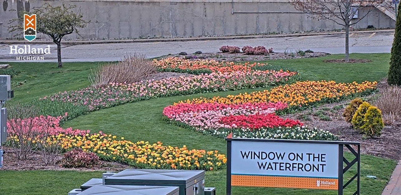
Beautiful tulips in bloom in Holland MI - blossoms coming out on the ornamental pear trees downtown. It’s a little early, but there are are both early and late blooming varieties of tulips that will show off their brilliant colors over the next month. Holland is a great place to visit during late April and early May.
Quick forecast: Still a chance of a shower or thunderstorm today - best chance south of a line from Holland to Saginaw - dry and relatively warm on Friday, low-mid 70s - a good chance of showers/storms Friday night into Saturday - windy and significantly colder on Sunday - an overall dry pattern early next week.