
Dry and Warm Today, Rain on Friday
We may not be done with frost yet.

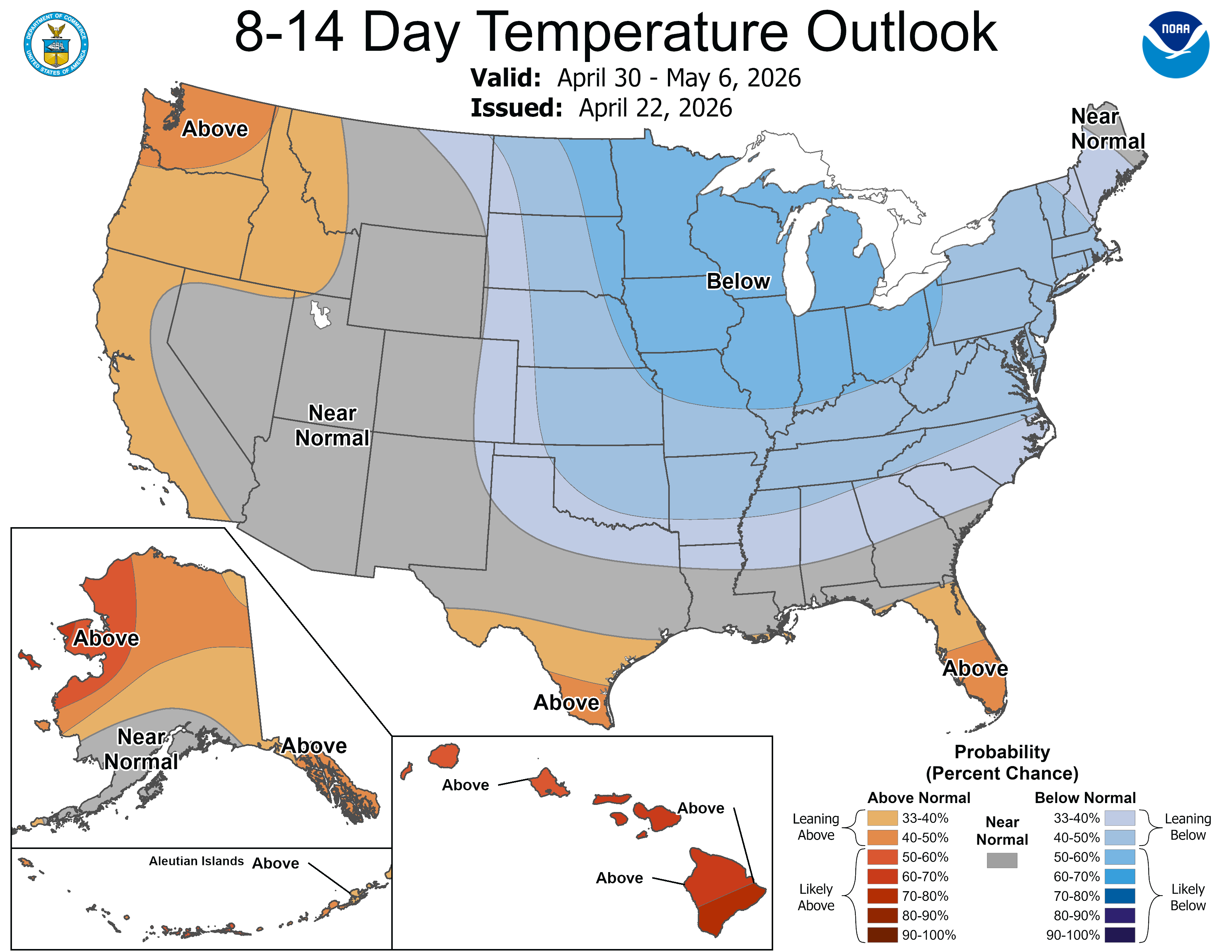
This is the 8-14 day temperature outlook from the Climate Prediction Center for April 30-May 6. Cooler than average temperatures are likely in the Great Lakes. It’s forecast to be warmer than average in the Florida Peninsula, South Texas and along the West Coast. With this pattern, we may not be done with frost in Lower Michigan. For much of West Michigan, the average last frost is in the first week of May.
So, for many of you, it’s probably best off to hold up on planting frost sensitive flowers and vegetables. Anything that can take a little frost can go in now. I planted some pansies Wed. afternoon.
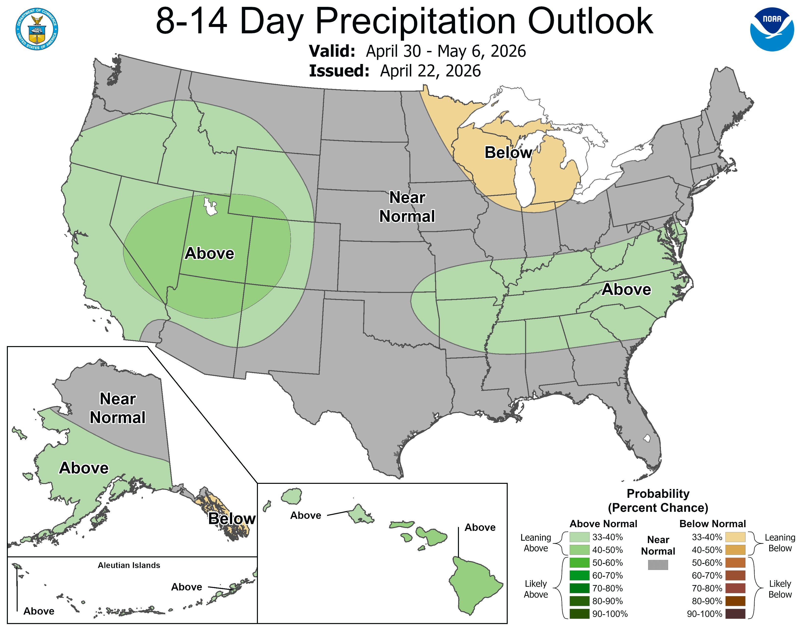
Some good news here for most of us. Rainfall is expected to be below average. This means mostly good weather for Tulip Time in Holland MI and rivers levels should fall back down to average levels.
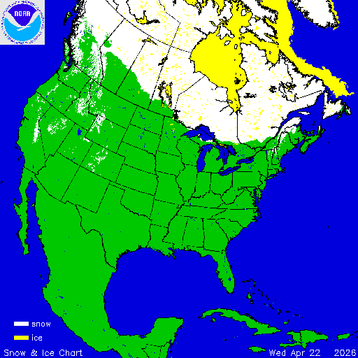
In May, cool air often comes down into Michigan from the north. In late fall and winter, cold air can come in from the west. There is snow on the ground now from the Lake Superior area north to the North Pole. Air that comes down from Canada in early May is usually cool air that has been over the snow pack and that has little time to warm up before it gets here.
The map above is North American snow and ice cover. Most of the big lakes in Canada are still frozen over. The polar vortex has been hanging around Hudson Bay for much of the late winter/early spring and the ice there is thick. Here’s the Polar Bear Tracker. The bears are still out on the ice and may be yet for another 6-8 weeks.
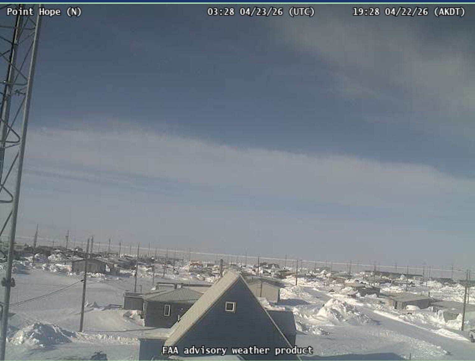
This is a screen grab from the webcam at Point Hope, Alaska. The sun is shining. Here, the days are getting longer at a fairly rapid clip. Today they get 8 1/2 minutes more daylight than yesterday. Today the sun rises at 6:35 am and doesn’t set until 11:37 pm. They are north of the Arctic Circle, so they get 24-hours of daylight during mid-summer. The sun will rise on May 24 at Point Hope and won’t set again until July 19th. You can see the winter snow has barely started to melt.
Yesterday, Deadhorse, Alaska had a high temperature of -8F and a low temperature of -20F. Bettles AK had a low temperature of -17F. They still have 23” of snow on the ground at Bettles. The Barrow Airport had a high temperature of -2F. Windy Point AK reported a snow cover of 150” on Wednesday. That’s 12 1/2 feet!
On the other side of the coin, Ketchikan AK, one of the wettest places in North America, has been dry for 3 of the last 4 days. Their April rainfall has only been 55% of average. They have now gone 16 days without a wind gust over 27 mph. Temperatures there have been pretty consistent. The warmest high temperature this month at Ketchikan has been 56° and the lowest high temperature has been 42°.
Ketchikan had 9.49” of rain in March. That’s actually below the average rainfall for March, which is 10.98”. This March, Ketchikan had measurable rain (and snow) on 28 of 31 days and a trace of rain on the other 3 days.
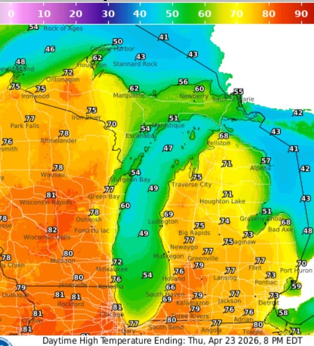
Here’s high temperatures today in Michigan. After a little scattered early morning fog, the sun will be out for much of the day. Inland areas should make a run at 80°. It will be cooler right at Lake Michigan in the PM. This will likely be the warmest day we’ll have the rest of this month and maybe the warmest day we’ll see until the 2nd week of May.
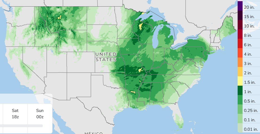
Here’s forecast rainfall for the next 3 days. For West Michigan, our rain will come in the form of showers and non-severe thundershowers Friday into Friday night. The weekend looks dry and pleasant.
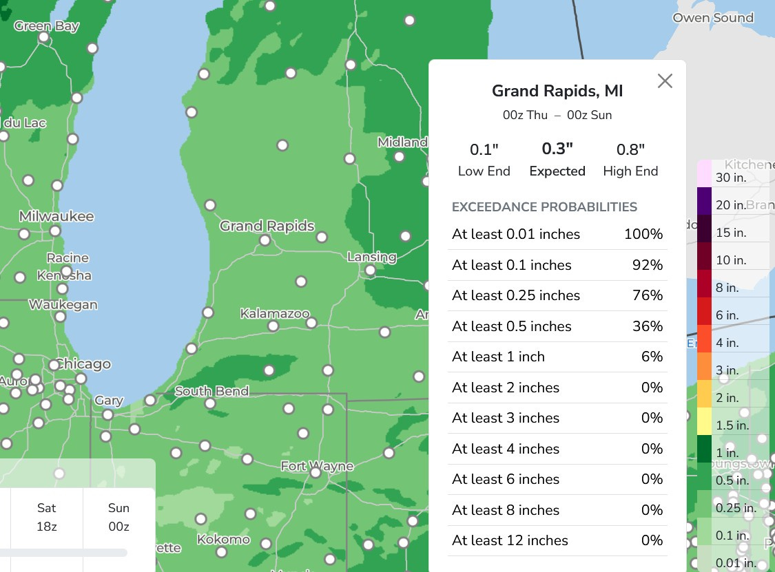
Here’s forecast rainfall for Grand Rapids Friday/Friday night. Expected is about 1/3rd inch…with a low end 0.1” (so the chance of rain would be high - 80-90%). We have a high end of around 3/4 inch. The rain looks pretty uniform…about the same amount across the whole area. This isn’t enough rain to cause a 2nd crest on mid-size and larger rivers.
Happy Thursday - thanks for reading my blog.
Thanks Bill for all the information