
Coldest St. Patrick's Day Since 1941
Also, it's the coldest day since Feb. and will be the coldest day of March


This was the coldest (daytime) St. Patrick’s Day since 1941 (85 years). It was the coldest afternoon in Grand Rapids since Feb. 8 and it will turn out to be the coldest day of the month.
The high temperature Tue. in Grand Rapids was 22 and that was 23 colder than average for March 17. The warmest St.Patrick’s Day was in 1978, when we hit a high temp. of 78. The coldest March 17 was a -4 reading in 1949.
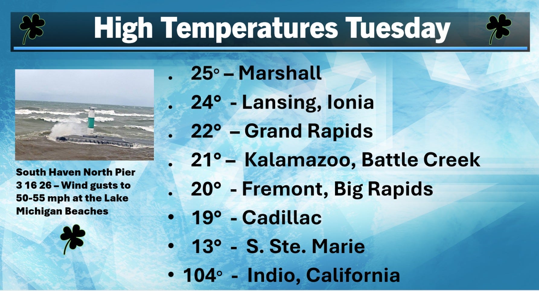
While it’s unseasonably cold here in the Great Lakes, it’s mid-summer hot in the desert Southwest. Indio CA was the hottest spot in the U.S. on Tuesday with a high of 104°
The pic. above is the north pier at South Haven. There were some big-time waves on Monday with winds gusting as high as 50-55 mph at the shore.
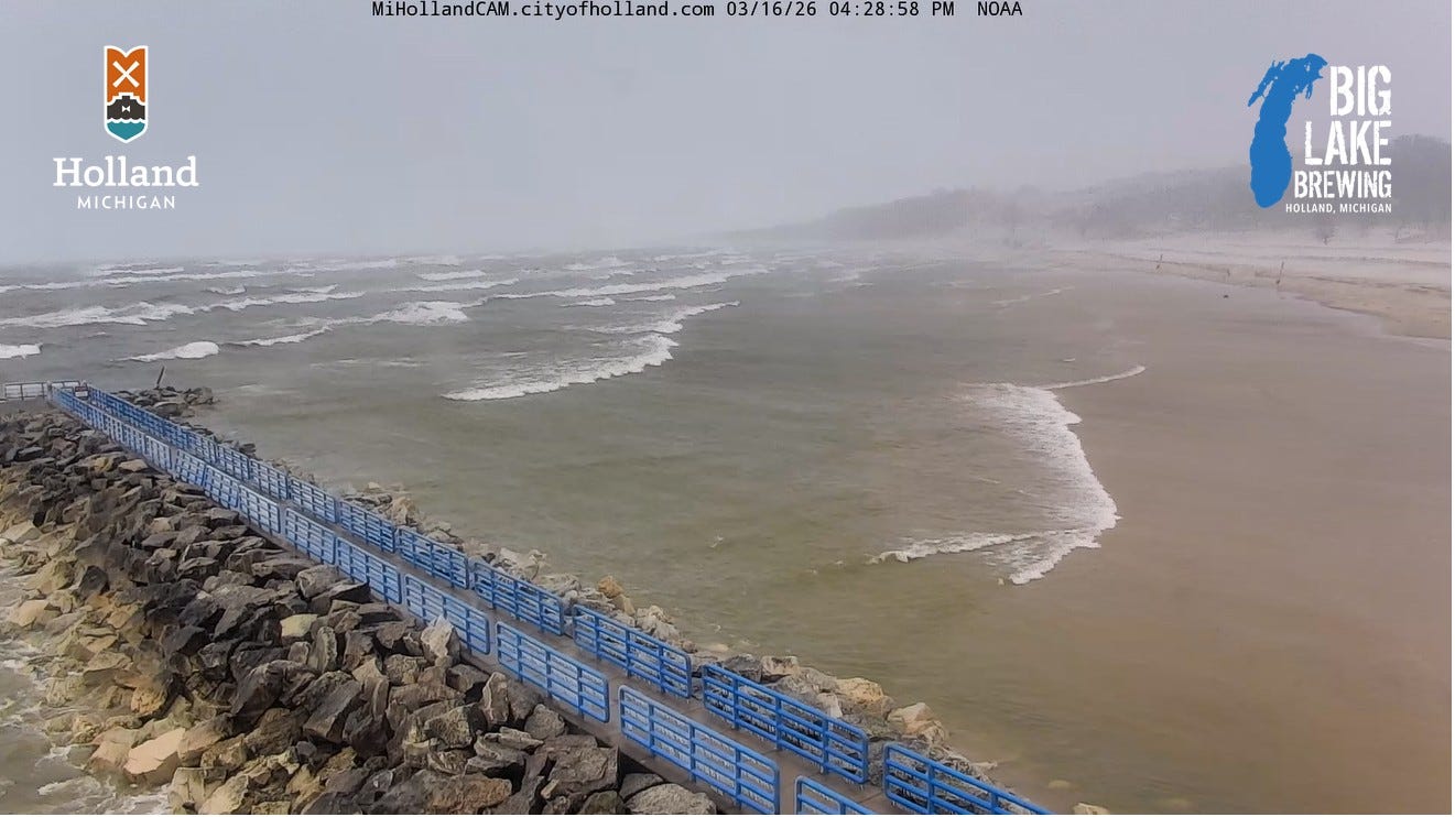
The strong winds produced what we call a “standing seiche” on Lake Michigan. The strong west wind pushes the water toward the Michigan shore, where the water levels rise. You can see the waves coming far up on shore. At the Wisconsin shore, the water level fell as water was pushed away from shore. The pic. (from the city of Holland) is from Monday afternoon.
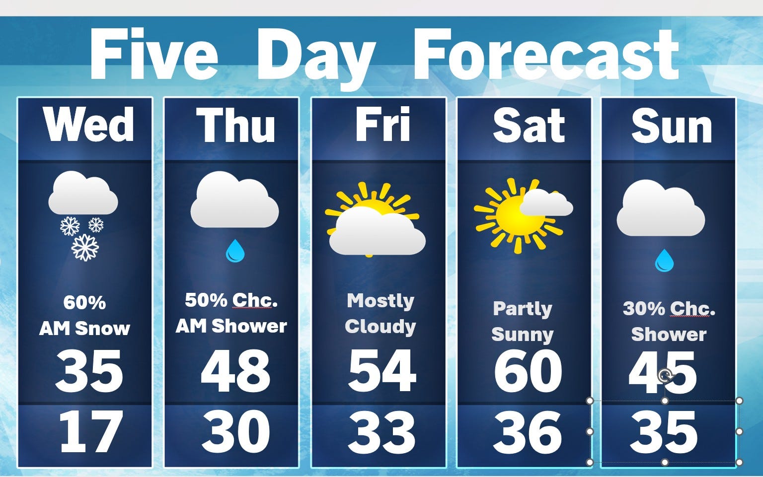
Here’s the 5-day forecast…today will be a good 10-15 degrees warmer than yesterday and tomorrow will be 10-15 degrees warmer than today. By Saturday, we could reach 60 degrees away from the lake. No big storms…a dusting this (Wed.) morning - an inch or two north of Muskegon. Then a chance of a light shower or sprinkle on Thursday. Sunday we could see an isolated light shower, but emphasize “light”.
A number of rivers are at bankfull. The Grand River in Comstock Park is a couple inches above flood stage. That may rise another inch or two before starting to go down slowly Thursday night.
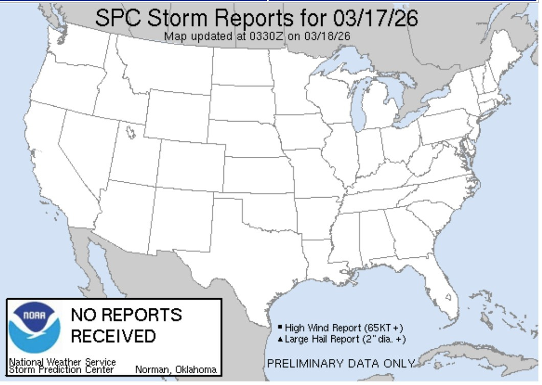
As of midnight EDT - there were no severe weather reports on Tuesday…not one. That’s quite a contrast from Sunday and Monday. Here’s Sunday’s severe reports:
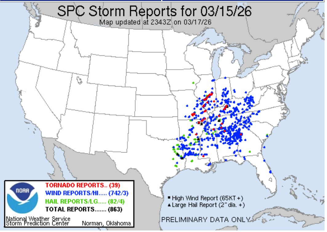
Wow! Thirty-nine reported tornadoes and 742 reports of wind damage. Here’s Monday:
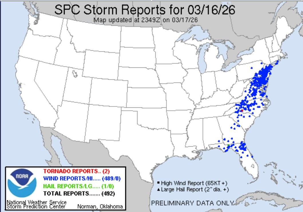
The severe weather shifted to the east on Monday. Combined Sunday and Monday there were 1,231 reports of wind damage (or gusts at or over 58 mph).
No severe weather today (Wed.) or tomorrow (Thu.). We may not see any thunderstorms at all in the U.S. today and we may not see a significant severe weather threat in the U.S. until next week.
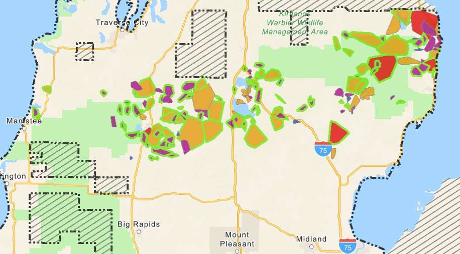
Here’s the Consumers Energy Outage Map from early Wednesday (3/18). There are still 56,734 customers without power. Freezing rain fell this weekend in a 40-mile wide area across Lower Michigan. The wind was too strong for crews to get up in the “cherry pickers” to fix the wires. There were a lot of wires downed by as combination of ice and strong wind.
This Wed. AM, Alpena Co. still had 88% of the county without power, along with 86% of Alcona County, 65% of Missaukee County and 63% of Roscommon County. With lighter wind Consumers should make good progress with getting people’s electricity back on today.
Marquette added 1.3” of new snow on Tuesday. They are up to 264” of snow for the winter and they have 51” of snow on the ground. That’s 97.2” above average-to-date.
Grand Rapids has had 75.2” of snow this winter and Muskegon has had 107.1” as of early Wed. AM.
"That’s 97.2” above average-to-date."
That's 8 feet! Oh, my!
No wonder I can't imagine myself living up there!
Thanks for including snow totals. I’m hoping after today that will be the last of it!