
Chance of Severe Weather
There is a chance (not a sure thing) of a thunderstorm tonight. Any storms that do form may contain gusty winds.

12{15 am pm Tuesday update: So far, 105 reports of severe weather from Texas northeast to Upper Michigan.
So far, a dozen reports of severe criteria with hail up to 3” in diameter at Mangum OK and winds to 74 mph at Estherville IA. Two tornadoes so far, at Kenyon MN and Falls Creek WI. Twenty reports of wind damage and 83 reports of severe criteria hail.
This (above) is the Severe Weather Outlook Map for this Monday night. The Storm Prediction Center has a Moderate Risk (level 4 out of 5 - in red on the map above) for N Iowa, SE Minnesota and W Wisconsin. The Moderate Risk Area is surrounded by an Enhanced Outlook Area (level 3 - in orange on the map above) that comes east to Lake Michigan. The Slight Risk area (level 2 - in yellow on the map above) includes the part of West Michigan that is west of a line from Grand Haven to Big Rapids to the Mackinac Bridge. Then there is a narrow Marginal Risk Area (level 1 - in dark green on the map above) that covers South Bend IN, Kalamazoo MI and Grand Rapids MI.
Activity should weaken as it tries to come east into Lower Michigan

Before I get to the chance of a storm tonight, there is an elevated wildfire risk in West Michigan this PM. The Grand Rapids NWS says: “highs in the mid-upper 70s, low relative humidity values and wind gusts upwards of 25 mph will bring an elevated fire danger to Lower Michigan today.”
There is a chance of a shower or thunderstorm tonight. It’s just a chance, not a sure thing. The Grand Rapids NWS says: “latest cams (convective-allowing models) continue to downplay the convection tonight into tomorrow. The best CAPE (Convective Available Potential Energy) will be north and south of southern Lower Michigan, bifurcating the region.”
If we get a storm tonight, there is a chance of some gusty winds and the most likely area to see that would be north of Muskegon along the lakeshore. The daytime this Monday should be dry and we should be able to get in the golf/softball leagues this evening. If we get a storm, it won’t likely be until or after sunset.
Also, Gale Warnings will be in effect for Lake Michigan north of Pentwater for gusts to 45 mph and waves up to 6-12 feet. The Gale Warnings start at 4 pm this Monday PM and run until 10 am tomorrow (Tue.).
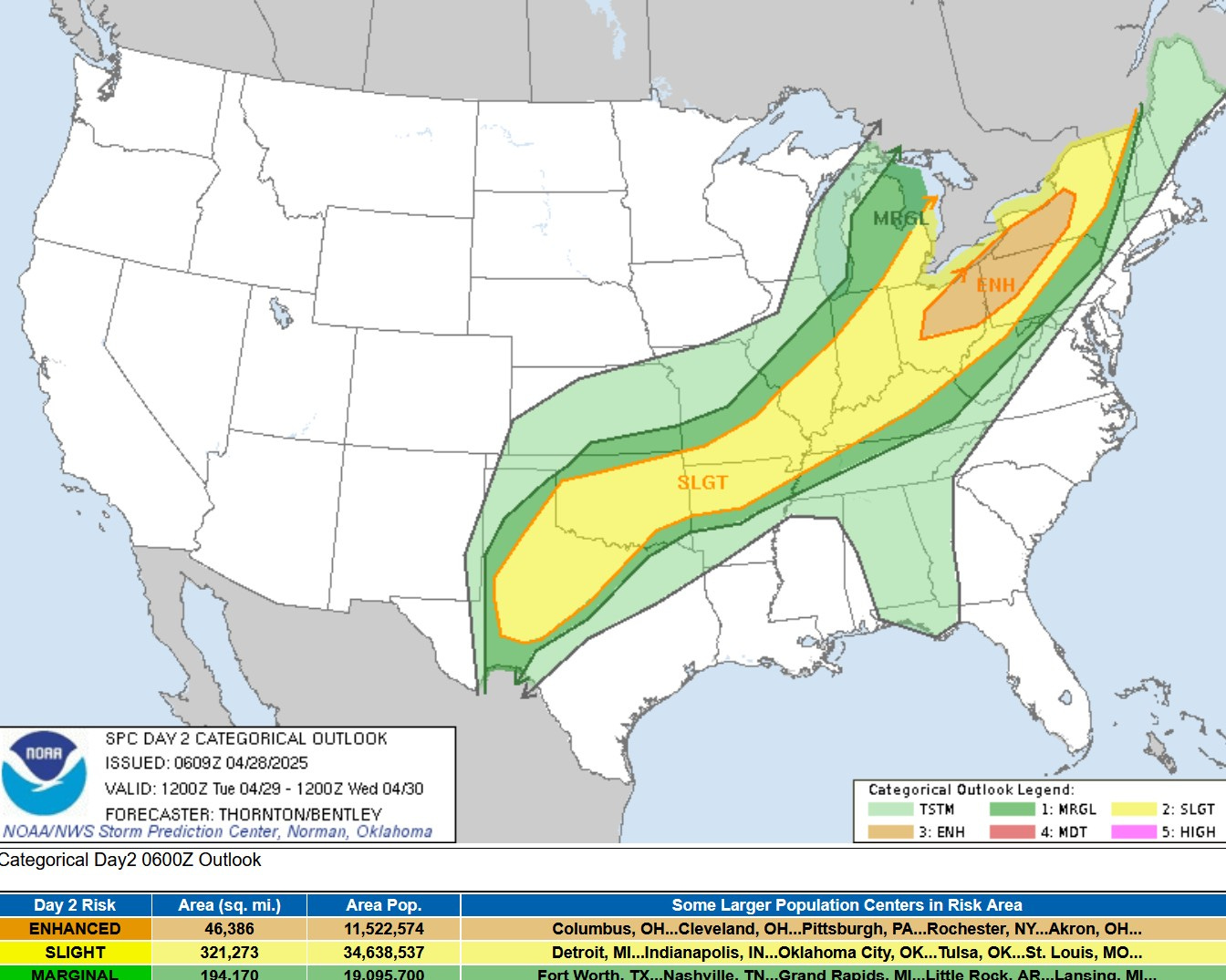
This is the Severe Weather Outlook Map for Tuesday/Tuesday night. The greatest risk will be in the orange area from Ohio into Pennsylvania and New York. The back edge of the Slight Risk (level 2) does include southeast Michigan (Detroit, Ann Arbor, Port Huron) and the Marginal Risk Area (level 1) includes much of the rest of Lower Michigan.
Storms will likely form along a cool front that will be stretched from Canada to Texas. While storms could form in Lower Michigan, the best chance of severe weather Tuesday afternoon should be south and east of Grand Rapids.
The Grand Rapids NWS says: “As the front moves east, have kept the higher probabilities of precipitation near Jackson to account for afternoon convection if the front lingers.”
Again, it looks like Tue. evening sports leagues and the Whitecaps game have a good chance of going on as scheduled.
There will be a chance of showers and storms later this week - Thursday into Friday with mainly dry and pleasant weather for next weekend (May 3-4).
**********************************************************************************************************
In other weather news - it remains quite cold in northern Alaska. Utqiagvik had a high temperature of just 12 on Sunday and Deadhorse climbed to just 13.
It’s also been cool and windy in the Southwest. The Hoover Dam had a gust to 64 mph on Saturday and Joshua Tree CA had a 65 mph gust. Las Vegas had a high temperature of 68 on Sunday (same as Grand Rapids) and that was 13 degrees below the average high of 81. Prescott AZ had a high of 59 (average high 71) and San Diego set a record low temperature of 47.
***********************************************************************************************************
So far, the month of April is running 0.1 degree warmer than average (or almost exactly average). Rainfall has totaled 2.77” and that’s 0.80” below average. We’ve had just a trace of snow. Our season snowfall total for Grand Rapids remains at 63.8”.
Last week was a much calmer week. For the six days from April 22-27, the average wind speed in Grand Rapids was 6.6 mph. The previous nine days from April 13-21 had an average wind speed of 13.5 mph.
Thank you