
Thunderstorms Stayed to Our South
Hundreds of severe weather reports in the South.


KFFC Radar (Atlanta) as the storms were moving through Georgia.
Severe storms stayed southeast of West Michigan on Wednesday.

Above is Storm Reports for Wednesday, March 5. There was one tornado in North Carolina that was rated EF1. Thre were 118 reports of wind damage with the highest wind recorded was a gust to 94 mph at Avon Pier, North Carolina. There was one report of a power pole down by strong wind at Grafton in Monroe Co. (far southeast Michigan).
Thunderstorms formed in Texas and Oklahoma and moved east across the South. So far, 7 tornadoes occurred on Tuesday with 3 already rated EF1 and over 175 reports of wind damage - isolated reports of wind gusts over 75 mph. There was an overturned semi at New Hope TX, major structural damage at Carrollton TX. A roof was taken off a downtown building at Lake Charles, Louisiana. There was a 70 mph gust at Fort Polk LA. and a 72 mph gust at Trenton, Texas. KHDC
Local radar Super Resolution Base Reflectivity
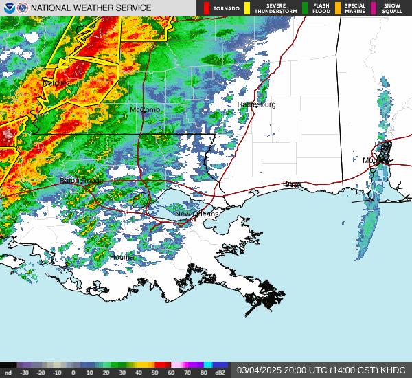
LIX - New Orleans/Baton Rouge, LA as the storms were moving through Louisiana Tuesday evening.
Strong-severe storms moved through the New Orleans area during Mardi Gras evening..
There was an Enhanced Risk (level 3) of a severe storm from northeast Texas and southern Oklahoma east to southwest Alabama and the western Florida Panhandle. The Slight Risk (in the yellow color on the map above) ran from Texas and Oklahoma up into east central Kansas and east to the Georgia/Alabama border. A Slight Risk is Level 2 out of the five risk levels.
Surrounding the Slight Risk is a Marginal Risk Area (in dark green on the map) from Texas up into southern Illinois and far southwest Indiana. The larger light green area is where there is a General Thunderstorm Risk - not severe. For this Tuesday PM, that comes north to southwest Michigan.
The Storm Prediction Center said: “ Severe thunderstorms with a threat for tornadoes, damaging winds, and isolated hail are possible today from eastern portions of the southern Plains into the lower Mississippi Valley and Southeast. A couple strong tornadoes will be possible. “


The map above shows severe storm reports from Tuesday/Tuesday night. There were 17 reported tornadoes, including 5 each in Oklahoma and Louisiana, 4 in Oklahoma, 2 in Mississippi and one in northwest Florida. Four people were injured in Whistler LA and there were 3 injuries in Winnsburo TX. Hail 3” in diameter hit Palestine TX and winds hit 79 mph at Hilshire TX.
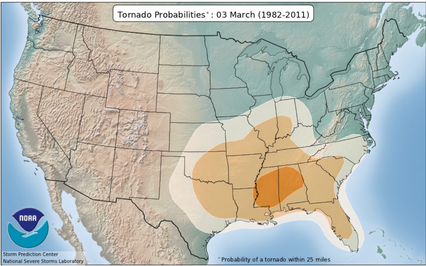
This map shows the probability of a tornado within 25 miles of a given point on March 3 in the U.S., based on 40 years of data. Th highest probability is from the Mississppi River east-northeast to the Alabama/Georgia border. Note that there is a higher probability of a tornado in Sturgis MI on March 3 than in Amarillo, Texas, Dodge City, Kansas or Omaha, Nebraska.
Here’s current lightning data…today’s storm reports…current severe thunderstorm and tornado watches…current radar…a current Michigan weather map (the temperature is the number in red in the upper left of each station plot).
This map from the Storm Prediction Center shows where severe weather has occurred in the U.S. so far in 2025. A red dot represents a tornado report, a blue dot is wind damage and a green dot is a severe hail report (1” or greater in diameter). Activity is centered over the Southeast U.S., though you can see a cluster of wind damage reports around Los Angeles. We have had any severe weather in Michigan. The warmer, more humid air hasn’t made it up into Michigan so far this year.

Through March 1, the U.S. has had 61 reports of tornadoes. That’s well below the Jan. 1 - Mar. 1 average of 105. That’s because it’s been colder than average. The tornado reports for this year so far are plotted in red on the map above. The black line is the mean number of tornadoes through the course of the year.
Since 2010, the year with the greatest number of tornadoes (2,240) is 2011 and the lowest annual total was 943 in 2013. That was the year of the big flood on the Grand Rapids in April.

As always, thanks for reading my blog.