
Strong Winds and Falling Temperatures
Squalls and thunderstorms brought 40-55 mph wind gusts to West Michigan


Here’s a list of some of the peak wind gusts Wednesday afternoon and evening. We had reports of trees down in Paw Paw and Watervliet.
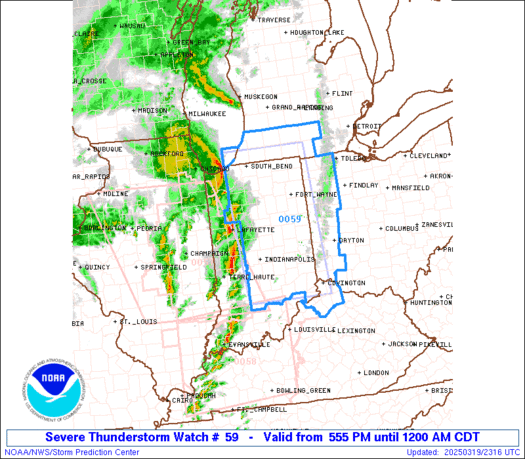
The Storm Prediction Center issued a Severe Thunderstorm Watch for areas south of a line from South Haven to Jackson (outlined in blue on the map above).


The above map was the Severe Weather Outlook Map from the Storm Prediction Center. The Storm Prediction Center had an Enhanced, or level 3 chance of a severe thunderstorm within 25 miles of a given point for a large part of central and northern Illinois and a small part of West Central Indiana. The Enhanced area is in orange on the map above. The Enhanced Area was surrounded by a Slight Risk (level 2) that now comes up into West Michigan, south of a line from Coldwater to South Haven with the Marginal (level 1) risk area extended north to US 10.
SPC said: “A strong mid-level low will move from northeast Kansas Wed. morning to Lower Michigan…The wind profile across central and northern Illinois will support supercells..Several tornadoes, large hail, and damaging wind gusts will be possible.”

Compare the two maps above…the area forecast to get the severe weather and where the severe weather occurred. You can see that once again, the Storm Prediction Center did a very good job forecasting the event.
As of 12:30 am, there were 9 reports of tornadoes, all in Illinois, 23 reports of wind damage (gust to 73 mph at Sullivan IL, 64 mph at Terre Haute IN)…semi’s flipped on I-55 and I-39 in Illinois.
We had a pretty strong front over West Michigan. At 7 pm Wed. it was 63 degrees in Big Rapids with a south wind and 41 in Ludingon with a northeast wind.
Our rain showers will turn to snow showers and flurries this Thursday AM with the possibility of a dusting to an inch on the grassy areas (especially north of Muskegon).

Here’s a look at some season snowfall totals as of early Thursday. They started keeping snowfall totals at Western Michigan University in Kalamazoo and reached 41.2” by February 13th, but they have not updated that total since then.
On the other side of Lake Michigan, Milwaukee has had 30.1” of snow this winter and Green Bay is up to 34.2”. So, you can see the difference Lake Michigan makes.
Nationally, Mt. Baker in Washington State has picked up 493” of snow this winter. They will soon surpass their season total of 508” for last winter. They hold the world’s record for most snow in a winter and that was 1,122” in the winter of 1998-99.

Speaking of snow. This is a webcam pic. from Mt. Rainier National Park in Washington State. The snow here is so deep that just the tops of the trees are poking through the snow cover.
Nearby Mt. Baker has had 493” of snow so far this winter. They will soon surpass the 508” that they had all last winter. Mt. Baker holds the record for the most snow ever in a winter season. That wa 1,122” in the winter of 1998-99
Thanks for reading my blog. Subscribe to my YouTube Channl at billsteffen616. It’s free.
Thanks for the snowfall updates. Pretty close to average it appears
thanks for including a write up also. I prefer reading the forecst and details.
Al